/https://tf-cmsv2-smithsonianmag-media.s3.amazonaws.com/filer_public/72/3c/723cefee-601b-46bb-bc96-99905cf05faf/gettyimages-1544052029.jpg)
New Satellite Tracking Air Pollution Releases Its First Images
The instrument, called TEMPO, will make hourly measurements of pollutants over North America that could help reduce exposure to unhealthy air
/https://tf-cmsv2-smithsonianmag-media.s3.amazonaws.com/accounts/headshot/Will-Sullivan-photo.png)
:focal(2192x1440:2193x1441)/https://tf-cmsv2-smithsonianmag-media.s3.amazonaws.com/filer_public/72/3c/723cefee-601b-46bb-bc96-99905cf05faf/gettyimages-1544052029.jpg)
A new, satellite-based instrument measuring air pollution in North America has sent its first images back to Earth, NASA announced in August.
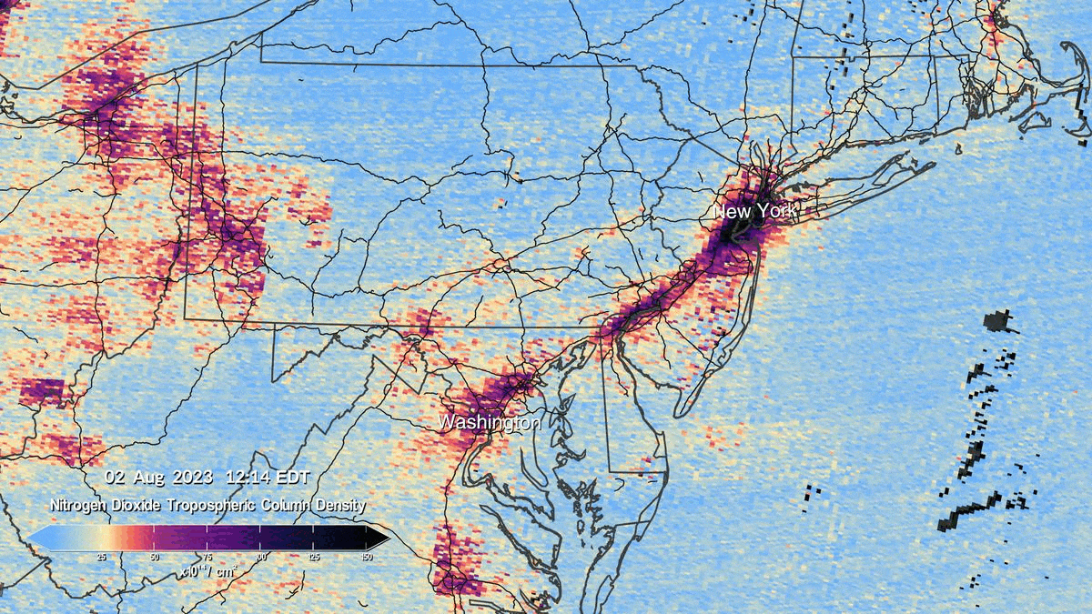
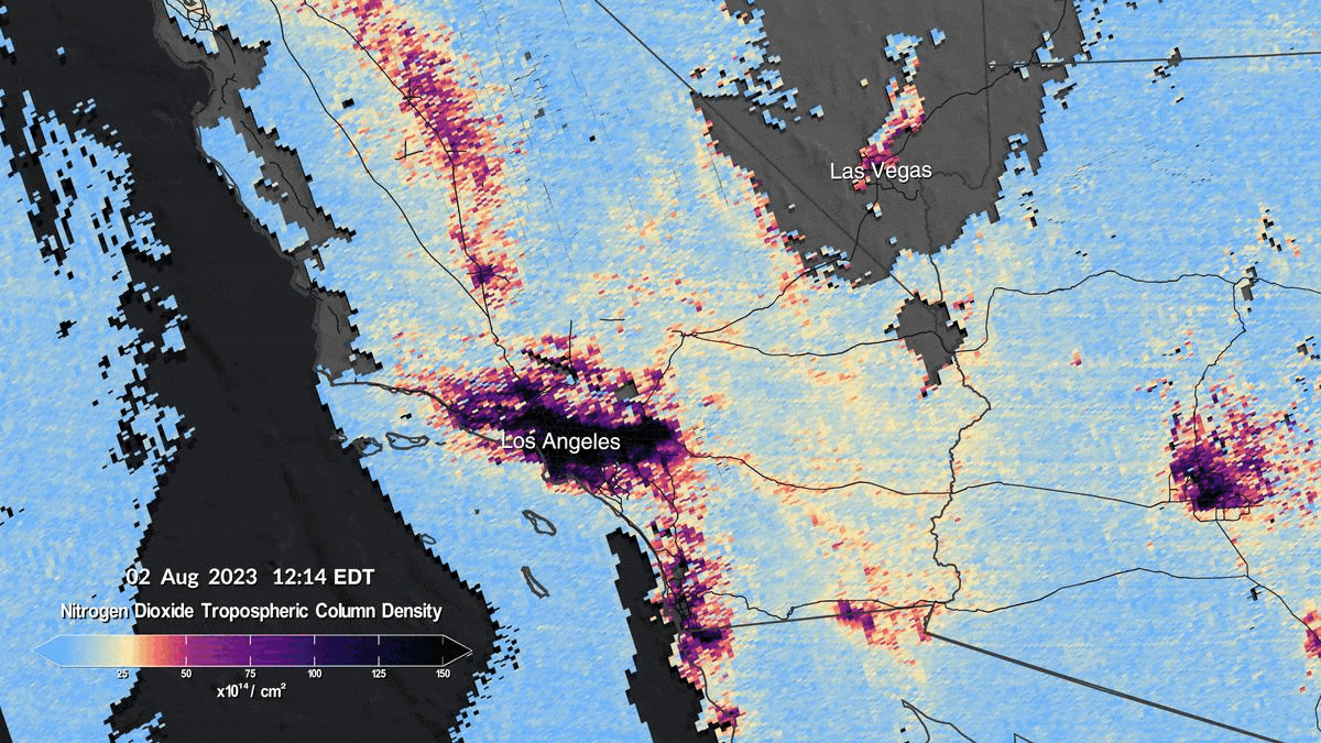
The early maps show levels of the pollutant nitrogen dioxide throughout the day on August 2, 2023. The instrument, called TEMPO (Tropospheric Emissions: Monitoring of Pollution), will observe the continent with a resolution as small as four square miles—about the size of the National Mall in Washington, D.C.—and it will snap images hourly during the daytime. Most other satellites looking at Earth only image a particular region once per day, so TEMPO will allow researchers to gather more detailed data than before, according to a statement from the Harvard-Smithsonian Center for Astrophysics (CfA), a collaborator on the project.
“Down here where we live, in the air that we breathe, there’s a lot of different things to be concerned about,” Kevin Daugherty, a project manager at NASA’s Langley Research Center, told Smithsonian magazine’s Brian Handwerk earlier this year. “Getting this high resolution … all the way across the country, I think, is going to be a really big step forward in being able to piece together where our major sources of pollution are and how that pollution moves.”
TEMPO launched from Cape Canaveral, Florida, on April 7 and entered an orbit about 22,000 miles above the equator. It’s attached to a geostationary telecommunications satellite—one that maintains the same position in the sky relative to Earth—allowing it to image the same sites in the United States, Mexico and Canada multiple times each day.
The instrument tracks visible and ultraviolet light reflected and scattered by Earth’s surface, atmosphere and clouds. Different gases absorb light of unique wavelengths, so TEMPO can identify which air pollutants are present based on the wavelenths of reflected light, writes Space.com’s Tereza Pultarova.
After undergoing testing, TEMPO took its first measurements between July 31 and August 2. The recently released images show nitrogen dioxide concentrations over North America at six different times on August 2 between 11:12 a.m. and 5:37 p.m. Eastern time.
“We are excited to see the initial data from the TEMPO instrument and that the performance is as good as we could have imagined now that it is operating in space,” Daugherty says in the NASA statement.
The close-up scans focus on the I-95 corridor in the northeastern U.S., the region between central Texas and New Orleans and the area surrounding Los Angeles and Las Vegas. Pockets of nitrogen dioxide pollution are visible over cities and transit routes.
Nitrogen dioxide is released into the atmosphere when cars, trucks, buses, power plants and off-road equipment burn fuel. Exposure in the short term can exacerbate respiratory diseases such as asthma and lead to hospital visits with respiratory symptoms. Long-term exposure can contribute to the development of asthma, per the Environmental Protection Agency (EPA).
TEMPO will also monitor levels of other pollutants, including aerosols, sulfur dioxide, ozone and formaldehyde emitted by automobiles, wildfires, oil refineries and other sources, per the CfA. More than a third of people in the U.S. live in places with unhealthy levels of air pollution, according to the American Lung Association. Air pollution is linked to between 100,000 and 200,000 deaths in the U.S. each year.
The instrument won’t start full operations until early October. Marshall Burke, an environmental policy researcher at Stanford University who is not involved in the TEMPO mission, tells the New York Times’ Delger Erdenesanaa that he is looking forward to the instrument’s hourly data. “As you have more and more images, it’s much easier to fill in the map of where things came from,” he tells the publication.
The data will help scientists better understand the impacts of air pollution at the community level. While the satellite’s observations won’t be publicly available until spring 2024, hundreds of government agencies and researchers have already signed up to get an early look at the data. Researchers at Mount Sinai Health System, for example, will use TEMPO’s information to study the link between air pollution and children’s asthma, per the Times.
NASA will also share observations with agencies that provide weather forecasts in hopes of reducing exposure to pollutants such as ozone.
“TEMPO has the potential to revolutionize forecasts of air quality in North America,” Caroline Nowlan, a physicist at the CfA, says in the CfA’s statement. “It will also serve as the North American component of an international constellation of satellites for air-quality monitoring.”
/https://tf-cmsv2-smithsonianmag-media.s3.amazonaws.com/accounts/headshot/Will-Sullivan-photo.png)