How Archaeologists Crammed 1500 Years of Roman History Into One Map
The Atlas of Ancient Rome looks at the city over the course of its evolution in remarkable detail
/https://tf-cmsv2-smithsonianmag-media.s3.amazonaws.com/accounts/headshot/lorraine.png)
/https://tf-cmsv2-smithsonianmag-media.s3.amazonaws.com/filer/f1/3a/f13a1e63-7f45-4937-97d8-94b96c1ca009/1024px-italy_by_frank_fox_10.jpeg)
Rome wasn’t built in a day, so it stands to reason that a modern map of the ancient city might take a considerable amount of time as well—almost a decade, to be precise. The task was a Sisyphean one (though that was a myth from Ancient Greece.) How do you represent 1,500 of the city’s 3,000 years’ worth of history in print format, showing how Rome evolved in each era, what was destroyed, what remained, how its citizens lived and died, and which streets they walked on?
Italian archaeologists Andrea Carandini and Paolo Carafa assembled a team to do just that. The result is The Atlas of Ancient Rome, a two-volume, 1000-page book that follows the development of Rome from the 10th century B.C. to the 6th century A.D. Compiling the book also required constructing and patenting a geographic information system into which they organized all their information.
“It’s a huge effort. You have to be a little bit of a fool [to attempt it],” Carafa admits. You also have to be deeply knowledgeable about the city’s archaeology—both Carafa and Carandini have been doing digs around the Palatine, the center of Ancient Rome, for 30 years—and be creative with new technology.
“We wanted to take into proper account not just the archaeological records or artifacts, but any information relevant for understanding,” Carafa says. That included everything from the various objects in architecture (ceilings, floors, wall paintings, columns, bases) to literary sources like inscriptions engraved in the stones and histories by the city’s former occupants. The database they created includes all of this and more: sculptures, bas-reliefs, coins, Renaissance paintings, 19th-century photography, videos of modern digs.
The end result is a geographic information system (GIS) that can produce maps of the city for different regions and time periods, distinguishing between the structures that are known with certainty in the material record and which structures require more interpretation based on written sources.
“Rome is like a human brain, a collective brain,” Carandini says. “It’s already been living for 3,000 years. That’s astonishing. We live at maximum around 100 years, so we control a tenth of a millennium. But Rome is still living on.”
Part of the inspiration for the Atlas comes from a much earlier attempt to do the same thing. Rodolfo Lanciani, a 19th-century archaeologist, used his own money to create Forma Urbis, a series of 46 detailed maps of the ancient city. The work had never been surpassed—until now. And the Roman version of the atlas is only the start. Next, Carafa and Carandini hope to look at Latium, the region immediately around the city of Rome, which conquering Romans used as a template for their military expansion across the region.
The Atlas of Ancient Rome: Biography and Portraits of the City
This compendium provides a comprehensive archaeological survey of the city of Rome from prehistory to the early medieval period.
“Rome is unique not just in terms of the quantity of information, but in terms of the complexity of the information. It was a stress test [for the modeling system],” Carafa says. “If it works in Rome, it will work everywhere.” That includes any other city or town around the world.
For now, the archaeologists are setting their sights closer to home. A number of Rome’s monuments and historical buildings have yet to be thoroughly studied, they say. Even the Palatine, where they spent 30 years digging, could use more research; less than 1 percent of it is thoroughly known in full archaeological terms, with material documented down to the virgin soil, Carafa says.
“Archaeology in Rome is very important, but [tourists] go to the Forum, the Colosseum, and they understand very little, because very little is explained,” Carandini says. He describes the surface-level tourism as “bite and escape,”—visitors take a nibble of a historical sandwich and leave without getting the rest. Carandini hopes that their project will inspire all people, be they scholars or curious tourists, to look deeper. “I think the possibility of the Atlas cannot be known in one year, but it will have an important influence.”
Introducing the Palatine (616-509 B.C.)
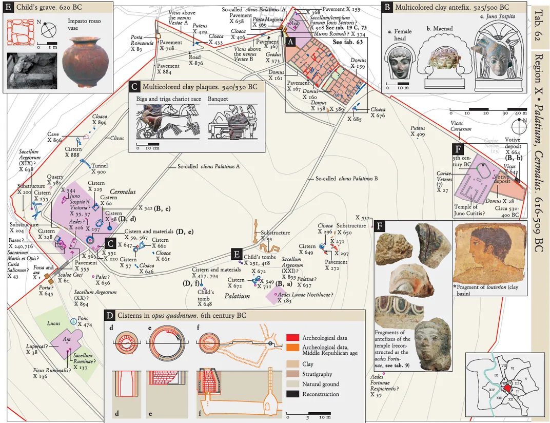
The Palatine is one of the seven hills of Rome, and its history goes back to the legendary history of the city. Palatine is the area where, according to Roman mythology, Romulus and Remus—the two brothers found and raised by a wolf—grew up. Palatine was also the site of the festival of Lupercalia, a mysterious rite where young men ran naked around the hill.
At this point in time, the city was in the late Roman Kingdom. (Rome went through three periods, beginning with the kingdom ruled by a monarch, then on to a republic, and finally ending with an empire ruled by autocrats.) According to Paolo Carafa, the sanctuaries still survive from earlier periods (scarlet areas at corners of the hill), but a new residential area filled with large houses has recently been built (letter A in Table 62 (above)). During this period the triumphal procession (used to celebrate military victories) was inaugurated by Tarquinius Priscus, the fifth king of Rome.
Imperial Rome (36 B.C.-64 A.D.)
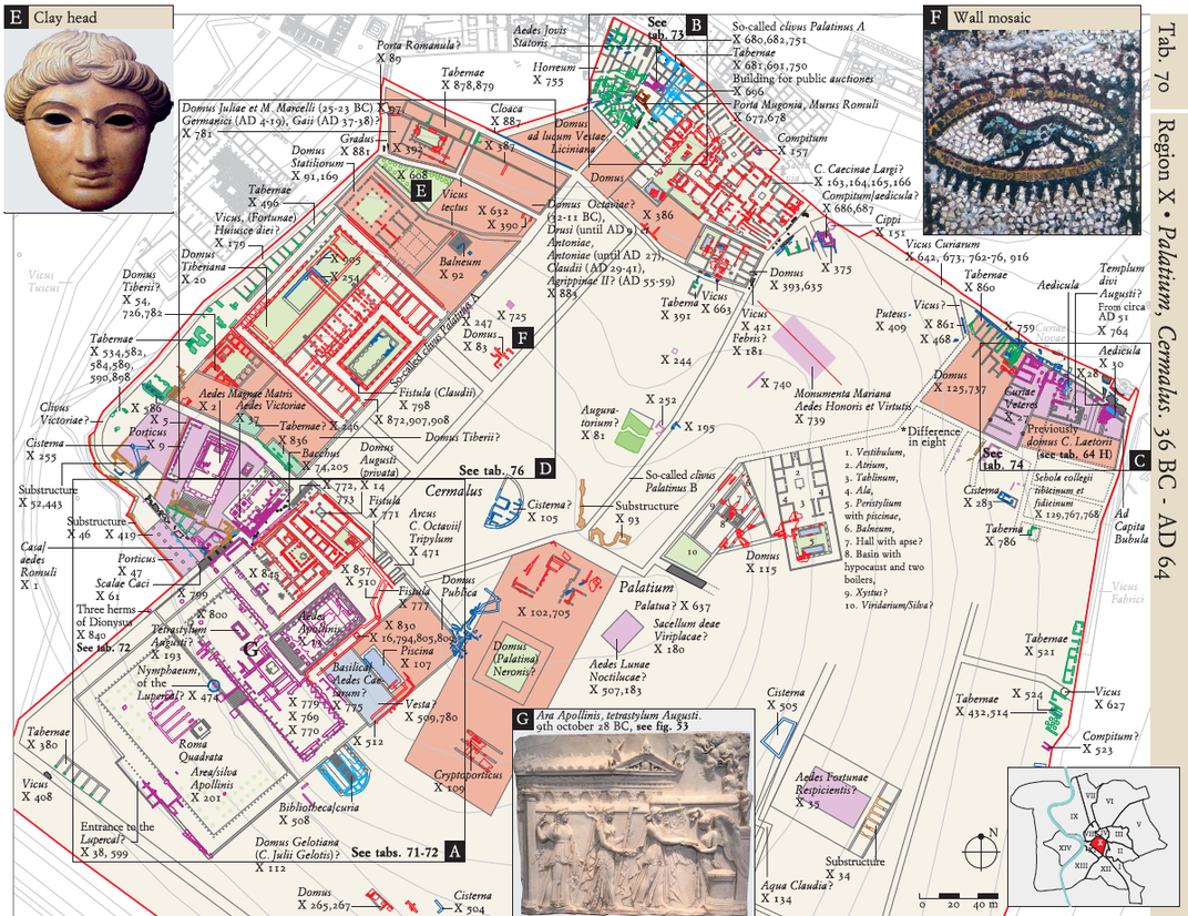
This era of the Palatine belongs to the Augustan age, when Caesar’s heir Octavian assumed the throne as the sole leader of the Roman Empire. Augustus destroyed his earlier house to build the first imperial residence on the hill (square A on Table 70, above).
At the center of the Temple of Magna Mater (X-13), reconstructed by Augustus, was the Temple of Apollo. The temple was dedicated in October of 28 B.C. and included statues of Apollo, Diana and Latona—the gods of music, the hunt, and the mother of Apollo, respectively—as well as vaulted rooms with gold tripods and collections of gems.
An Opulent Palace (81-90 A.D.)
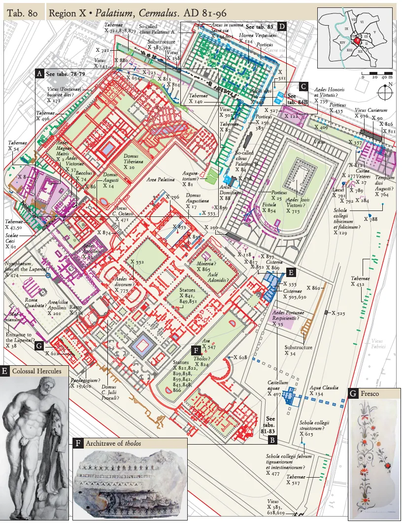
Here is Palatine Hill (from Table 80) during the reign of Emperor Domitianus, when it was turned into one enormous palace. Domitian’s structure was so enormous, it was described as a heavenly palace “so tall that the pyramids of Egypt seemed ridiculous in comparison,” according to his court poets. The palace was in fact 49,000 sq. meters (527,000 sq. ft.)—almost five times the size of the largest residence in the United States.
To show off his wealth, Domitian gave banquets to which he invited as many as 1,000 people. The guests were divided into groups based on their familiarity with the imperial family and their social rank, and then divided into different rooms that Domitian would pass through to greet them. The estate went on to be used by subsequent emperors, and its ruins are still visible in Rome today.
/https://tf-cmsv2-smithsonianmag-media.s3.amazonaws.com/accounts/headshot/lorraine.png)