Despite Road-Closing Landslides, You Can Still Take a Big Sur Road Trip This Year — Here’s How
This gorgeous stretch of coastline is harder to get to these days, but it’s not impossible
/https://tf-cmsv2-smithsonianmag-media.s3.amazonaws.com/filer/87/44/87447702-3b8d-460a-82fa-12989fbedf42/lone-cypress-pebble-beach-california-bigsurrt0518.jpg)
Stretching 90 miles along the jagged western edge of the continental United States, Big Sur has long exercised a magnetic pull on people drawn to its dazzling landscape.
Here, earth and ocean meet, not with gently sloping sands but with muscular mountains bristling with redwoods, and rugged cliffs that drop into the turquoise surf below. Just 150 miles south of San Francisco and 300 miles north of Los Angeles, this oblong slice of California is endearingly, enduringly wild.
When construction on a highway tracing the coastline was completed after 18 years in 1937, Big Sur officially opened to the public. Today, roughly 3 million people pass through it each year, slaloming down Highway 1 on one of the county’s most iconic lengths of road.
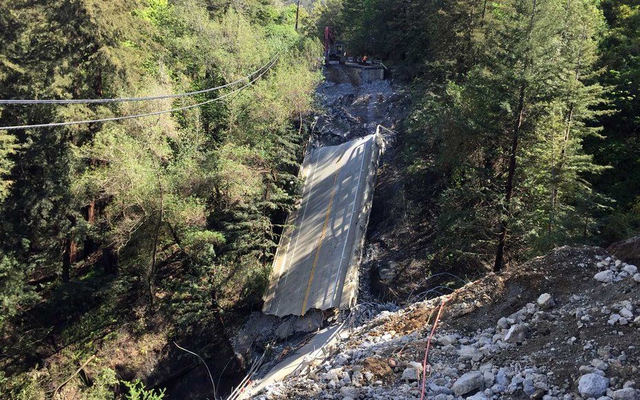
However, that road is currently closed in four places, cut off by a crumbling bridge and a handful of landslides that have blanketed the asphalt in dirt and rock.
“There are a lot of people with a vested interest in seeing the road open up again,” said Rob O’Keefe, chief marketing officer for the Monterey County Convention and Visitor’s Bureau. “This is literally the quintessential California road trip experience that’s broken.”
The closures are expected to cost the area $500 million in lost revenue, but even if you can’t cruise Highway 1 from Carmel to San Simeon this summer, much of Big Sur is still open for business. If reaching sections of this mythic coastline require more of an adventure than usual, that’s just part of the appeal.
What happened?
Last summer, the Soberanes Fire tore through 130,000 acres of Big Sur, burning for almost three months before finally being brought under control. That brutal season was followed by an incredibly wet winter, with ongoing rains saturating ground already susceptible to slides.
In February, a slip at Pfeiffer Canyon Bridge caused irreparable damage to the supports and span, closing the bridge and highway and effectively cutting off Big Sur village to the north from the businesses to the south. A handful of other slides have been active since January with periodic closures, and in May the region was rocked again: At Mud Creek, an entire hillside collapsed, burying a quarter mile of roadway under millions of tons of rock and dirt. The region’s worst landslide in 30 years, Mud Creek has actually changed the topography of the coastline, creating a new 16-acre crescent of earth that juts into the Pacific.
Meanwhile, 15 miles north of Mud Creek, Paul’s Slide also fell, isolating the stretch of highway between it and the bridge that’s home to Post Ranch Inn, Ventana Inn and Nepenthe Restaurant, among other businesses. Finally, Cabrillo Highway is also closed to the south at Ragged Point, where another slide has interrupted traffic at Ragged Point.
Can I still get there?
Yes, but you may have to work a bit more for it.
North of Pfeiffer Canyon, Big Sur is open as usual. The bridge itself has been fully demolished, and a replacement won’t be installed until September, however, starting July 1 you can get around the closure on foot. A trail for locals bypassing the gap has been carved into the hillside and will open to the public next month with shuttles operating on either side.
“It’s not an easy walk,” cautions O’Keefe, who’s done the 40-minute hike himself. But it is a unique entry to Big Sur.
On the opposite end of the sweat equity spectrum, elegant clifftop resort Post Ranch Inn reopened in April with a novel approach to its transportation woes: helicopter shuttles from Monterey. “The goal for this spectacular helicopter experience is to encourage the comeback of Big Sur and welcome guests in true Post Ranch-style, while showcasing the world-famous Pacific coast views from above,” said Inn spokesperson Kelsey Gummow. It’s an experience with an expiration date: Helicopter transfers aren’t usually available, and once the bridge reopens, flights will end.
Finally, there’s Nacimiento-Fergusson Road, a remote, twisting mountain pass that originates inland near the 101, then winds over the Santa Lucia Range to the coast. “It’s a focused drive,” said Megan Handy, front desk manager of Treebones, whose family owns the famed glamping resort. “It should be driven with care during daylight hours.”
The narrow road has no gas stations, no cell phone reception and no services of any kind, but it does offer access to the 14-mile slice of Big Sur between Paul’s Slide to the north and Mud Creek to the South that’s home to Limekiln State Park, Kirk Creek and Plaskett Creek campgrounds, and, of course, Treebones.
“We only had to close for three weeks back in February,” Handy said. “All of our guests have been coming in and out of Nacimiento-Fergusson Road. The majority of people are still making the trip."
Where can I have the Big Sur experience?
In the north
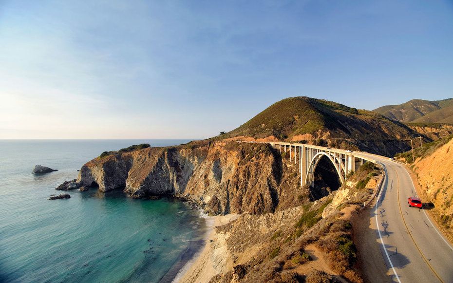
From redwood forests to rugged coastline, Big Sur’s grandeur is easily accessible north of Pfeiffer Canyon, where you’ll find the most dense concentration of businesses as well as iconic vistas like Bixby Bridge’s graceful arches. Garrapata State Park is open west of Highway 1 with two miles of beachfront where sea lions, otters and gray whales make appearances, and a handful of trails are open to walkers inside Pfeiffer Big Sur State Park. The park’s Main Camp sites are operating on a first-come, first-serve basis, and the lodge is also welcoming guests.
Spend the night at Glen Oaks Big Sur, where a variety of accommodations nestled among the redwoods pair rustic designs with modern amenities, or bunk stop at the Big Sur River Inn, a historic motel known for its apple pie and the Adirondack chairs that visitors pull into the river to relax with a beer.
Beyond the bridge
If you’re up for the trek, this is the time to experience Big Sur in relative solitude. South of the bridge is “really beautiful right now because it’s only locals there,” said Big Sur Chamber of Commerce Executive Director Stan Russell. “You can stand in the middle of Highway 1 and watch birds.”
Starting July 1, leave your car at Andrew Molera State Park and hop the shuttle to Point Sur Station, where you’ll pick up the bypass trail. Once you’re beyond Pfeiffer Canyon it’s a quick stroll to the Big Sur Deli and Taphouse for cold pints and hefty sandwiches or a short shuttle ride to the landmark Nepenthe restaurant, with its expansive patio overlooking a classic Big Sur view. Both have stayed open despite the road closures, serving as rallying points for locals isolated on “Big Sur Island.” Esalen Institute, the counter culture spiritual retreat known for its nude cliffside hot springs, is scheduled to reopen July 28 after five months of closure.
If money’s no object, consider Post Ranch Inn’s Escape Through the Skies package, which will whisk you comfortably over the road closures and straight to the resort, where elegant clifftop bungalows mirror the local hills with curving designs and amenities include wood-burning stoves, private hot tubs and decks that feel like they’re floating over the ocean or mountain ravines. Yoga classes and guided nature walks are included in your stay, and should you want to explore beyond the hotel, hop a chauffeured Lexus Hybrid or borrow an electric bike, and take on Big Sur’s famous curves while the road is essentially traffic-free.
In the middle
While Treebones’ yurts, campsites and human nest are usually booked solid this time of year, right now there are openings on the calendar. Seize the opportunity and brave Nacimiento-Fergusson Road to reach this 14-mile swath of Highway 1, which includes Limekiln State Park’s magical landscape of redwoods and waterfalls, prime coastline at Sand Dollar Beach and three campgrounds. If you can’t snag a spot at Treebones, consider Kirk Creek Campground, set on a bluff just 100 feet above the mighty Pacific.
In the south
From San Simeon, the southernmost section of Big Sur is accessible until Ragged Point. That means road trip-worthy highway, breathtaking coastal panoramas and destinations like Piedras Blanca Light Station (with free hike-in tours June 28, July 26 and August 30) and Hearst Castle, the opulent estate built by W.R. Hearst. Formerly known as Enchanted Hill, guided tours cover sections of this 165-room American palace that stands in stark contrast to its setting: fog-wrapped, ocean-battered Big Sur, where nature exerts its power again and again.
Other articles from Travel + Leisure:
- Can Three-Day Weekends Can Help Save the Planet?
- If You’re Having Trouble Sleeping, a Weekend of Camping Could Be the Cure
- The Best Fourth of July Celebrations Across the U.S.
Planning Your Next Trip?
Explore great travel deals
A Note to our Readers Smithsonian magazine participates in affiliate link advertising programs. If you purchase an item through these links, we receive a commission.