Stunning View of Arctic Could Be Last of its Kind
/https://tf-cmsv2-smithsonianmag-media.s3.amazonaws.com/filer/2012061905393506_19_2012_White-Marble.jpg)
Scientists working with data collected by NASA’s new Suomi NPP satellite put together this absolutely gorgeous view of the Earth’s icy north. The image, which shows the Arctic polar ice cap, a green Europe poking out of the clouds on the left, and northern Africa, the middle east, and Asia, was made by stitching together data collected by 15 separate orbits of the polar region. The original version is computer-freezingly massive at its highest resolutions, up to 11,000 pixels across.
NASA Goddard Space Flight Center scientist Norman Kuring put together a series of similar images back in February that focused on central America, Africa, and Australia. There is even a great behind-the-scenes look at how such stunning composite pictures are made.
The most intriguing aspect of the new Arctic image, though, is that this could be one of the last times we’ll be able to get a picture like this.
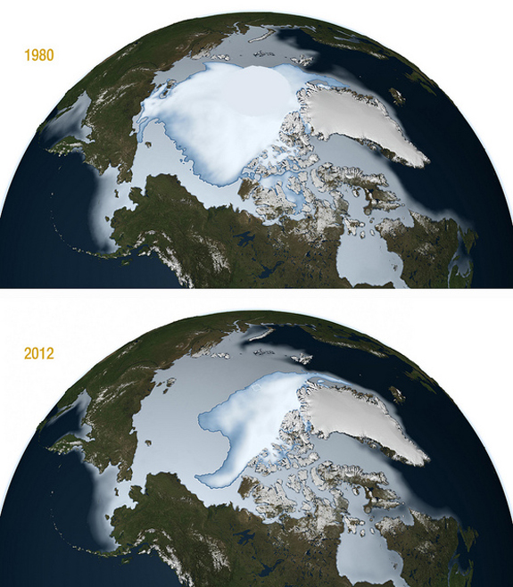
Sea ice in the Arctic is disappearing blazingly fast, and by June the summer melt season is usually well underway.
“The trend for summer sea-ice extent since 1970 has been downwards, with the past five years (2007–2011) being the lowest of the bunch.
… he last round of models from the Intergovernmental Panel on Climate Change predicted that the Arctic Ocean would be free of floating summer ice by 2070–2100, but in reality it looks likely to happen between 2030 and 2050. “2030 may be more realistic,” says Walter Meier of the National Snow and Ice Data Center (NSIDC) in Boulder, Colorado.” reads Nicola Jones’s Towards an Ice Free Arctic.
So, were this picture made a few decades from now we’d probably be referring to it as just another “Blue Marble” rather than a “White Marble.”
/https://tf-cmsv2-smithsonianmag-media.s3.amazonaws.com/accounts/headshot/smartnews-colin-schultz-240.jpg)

/https://tf-cmsv2-smithsonianmag-media.s3.amazonaws.com/accounts/headshot/smartnews-colin-schultz-240.jpg)