Scientists Map Buried Flood Channels on Mars in 3D
Deep channels, buried under lava but now mapped with satellite data, give hints to the planet’s violent, wet and recent past
![]()

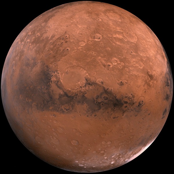
Mars, photo via Pixabay
Roughly 3.5 billion years ago, Mars began to shift from a wetter, warmer climate to the dry and cold planet we see today. This period of geologic change, known as the Hesperian age, was a turbulent time. The red planet saw widespread volcanic eruptions and catastrophic flooding as melted ice rushed into wide craters, forming lakes. These natural disasters carved a network of basins into its surface called outflow channels, eroding the terrain and reshaping the landscape of the planet. The exact end of this geologic period in Mars’ history is unknown, but scientists give a rough estimate of 3 billion years ago.
Later, many of these outflow channels became covered with lava, burying evidence of Mars’ geologic history. But now, a new map of the planet’s subsurface shows for the first time what one of these buried channels looks like in three dimensions. The findings, published today in the journal Science, reconstruct the Marte Vallis, the largest of the youngest channels on Mars. Marte Vallis is located in the Elysium Planitia region, an expanse of plains along the equator and the youngest volcanic region on the planet.
To create the 3D map, the researchers used data from Shallow Radar, a device that probes for liquid or frozen water underneath Mars’ crust. Known as SHARAD, the technology is on board NASA’s Mars Reconnaissance Orbiter spacecraft, which is currently circling the planet to study its climate. SHARAD’s orbital sounding radar works in much the same way as medical imaging scans. It sends signals to the surface, some of which automatically bounce back to the spacecraft. The signals that don’t readily bounce back can penetrate Mars’ crust and register buried structures before returning to the device. The data appears in two-dimensional cross sections, which are then pieced together to build the 3D representation. In this manner, a deeply grooved set of channels was revealed.

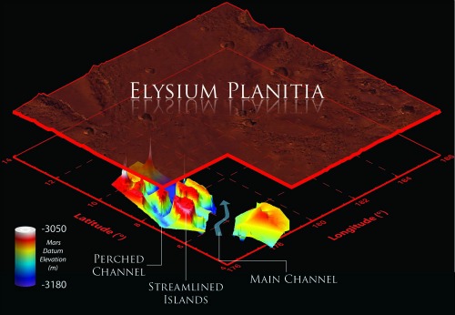
3D visualization of the buried Marte Vallis channels underneath the surface of Mars. Image via Smithsonian Institution/NASA/JPL-Caltech/Sapienza University of Rome/MOLA Team/USGS
The system of channels, which is somewhere between 10 million to half a billion years old, spans 60 miles in width and stretches for more than 600 miles in length. From what can be seen of Marte Vallis from the surface, the channels are similar in structure to more ancient channel systems traced to the Hesperian, but the lava that had obscured many of their features made it difficult for researchers to make accurate estimates about its depth.
The new data reveals that the scale of erosion for Marte Vallis had indeed been underestimated: the 25-mile-wide main channel is at least twice as deep than earlier approximations indicated. The map shows multiple perched channels which feed into the deeper and wider main channel. These channels once lay along a series of four islands, which floods eroded into teardrop-shaped hills.
The researchers found that the geometry of the features are similar to those of the planet’s oldest channels, which are less obscured by lava, making them easier to study. This also suggests that the Marte Vallis could have been carved entirely by water, says lead study author Gareth Morgan, a geologist at the National Air and Space Museum’s Center for Earth and Planetary Studies. In fact, most Mars scientists accept that outflow channels on Mars were carved by water. Lava also carves out tunnels through thermal erosion heating up the terrain, but Morgan says that this process is implausible for the scale of erosion at the Marte Valle channels. The speed of rushing water is also more efficient at erosion that the flow of lava, which can get stuck on rock, Morgan says. In addition, lava creates tunnels that aren’t as wide—typically only several miles across—so collapsed tunnels couldn’t account for the broad size of the channels.
Using the map, researchers were also able to pinpoint the source of the floodwater: a now buried portion of the Cerberus Fossae fracture, a series of fissures in the planet’s surface. The researchers posit that water from a reservoir deep below Mars’ surface was released by nearby tectonic or volcanic activity, and it worked quickly to form the channels. These channels would have been a short-lived affair,” Morgan says. “The fracture would have connected this groundwater to the surface. After a short duration of weeks or months, the source would have been exhausted.”
But why was water in that reservoir during a time when the rest of Mars is believed to have been dry? Water, the authors believe, could have collected in aquifers below the surface during the Hesperian. This water hypothetically could have remained stable in liquid form long after the Hesperian ended. Morgan feels that the 3D map could provide more evidence to support this hypothesis, showing that Mars was wet place in the more recent—as opposed to far ancient—past.
More than 20 similar outflow channels are spread out on the surface of the planet, extending hundreds of miles in length. The most prominent are located in the Chryse Planitia, a circular volcanic plain in the northern hemisphere of Mars. The largest, the Kasei Valles, runs for 1,500 miles along the plain.
Cataclysmic floods like the ones that shaped Mars’ channels aren’t unique to the red planet. Approximately 14,000 years ago, the largest known flood on Earth sprang from Lake Missoula, a prehistoric body of water that existed at the end of the last Ice Age in present-day Montana. The waters eroded part of the landscape of Washington state, forming the Channeled Scablands, a terrain that resembles Martian outflow channels. Marte Vallis’ main channel is estimated to be between 226 and 371 feet deep, a depth that’s comparable to the Channeled Scablands.
So if Mars’ expansive outflow channels were formed by gushing water, the question remains: Where did it all ago?
Some of it vaporized, drifted to the planet’s poles, and precipitated as ice on polar caps, Morgan says. Similar to the ones we have on Earth, the polar ends on the Red Planet are covered in miles-thick layers of ice. The water also could have pooled into shallow areas below the surface, where it also froze—in 2008, NASA’s Phoenix mission confirmed that ice exists in the porous soil that makes up much of the planet’s surface.
Another possibility, Morgan says, is that the ancient water again escaped deep underground, forming a large reservoir that awaits its chance to flood again.
/https://tf-cmsv2-smithsonianmag-media.s3.amazonaws.com/accounts/headshot/marina-koren-240.jpg)
/https://tf-cmsv2-smithsonianmag-media.s3.amazonaws.com/accounts/headshot/marina-koren-240.jpg)