A View From Above of Memphis Flooding
/https://tf-cmsv2-smithsonianmag-media.s3.amazonaws.com/accounts/headshot/Sarah-Zielinski-240.jpg)
/https://tf-cmsv2-smithsonianmag-media.s3.amazonaws.com/filer/20110520102452544160main2_memphis_tm5_2011130.jpg)
The Mississippi River doesn't like to stay where it is, but then most rivers prefer to meander, expanding beyond their banks on occasion, at other times forging new paths across the landscape. This isn't a problem unless you've built cities and towns and farms up and down its banks, as we've done. And so flooding happens, despite our best efforts to control the waters and keep our rivers safe and predictable.
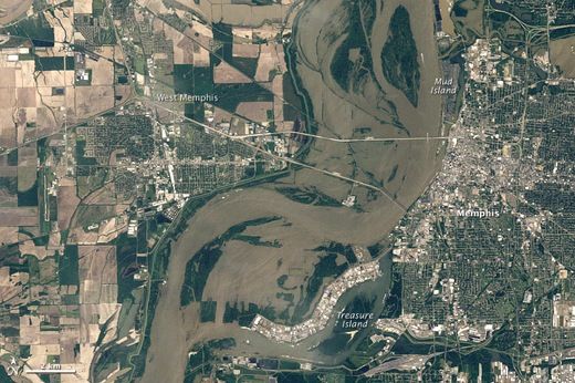
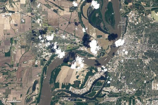
The current Mississippi River floods are slowly working their way south (that's Memphis in the Landsat photos, on May 10 (top) and April 21; waters reached nearly 48 feet), and already more than 3 million acres of land have been put underwater and thousands of people have been driven from home. Those waters are expected to crest in the coming days in Louisiana where the state has a rather nasty choice to make---open up the Morganza Spillway north of Baton Rouge, thereby flooding farms for 200 miles, or try to sandbag a similar distance in levees and hope that they're not overtopped. If the levees don't hold, New Orleans will be drowned in more water than the city saw during Hurricane Katrina.
If the water were diverted, it would go down a Mississippi River distributary, the Atchafalaya River, which is the shorter route to the ocean and the route that the river may prefer now. The Mississippi has not always drained into the Gulf of Mexico at its current location; that point has been as far west as Texas and as far east as the Florida panhandle in the geologic past. Scientists in the 1950s predicted that the river would soon divert its course and flow out to the Gulf through the Atchafalaya, which would render the New Orleans port unusable and set Morgan City to the west under water. In the 1960s, the Army Corps of Engineers set up the system of flood controls that exists today, splitting up the Mississippi's water so that only 30 percent flows down the Atchafalaya and preserving the status quo. But it's unclear if that system will survive this latest round of flooding (Salon has a nice write-up on this subject).
Which brings me to something I've been musing all day: If the Mississippi drains through the Atchafalaya, would our most-famous river take on that name? Or would the Atchafalaya cease to exist? I know, it's a small matter, but I'd rather think on that than on death and destruction.
Check out the entire collection of Surprising Science’s Pictures of the Week on our Facebook page.
/https://tf-cmsv2-smithsonianmag-media.s3.amazonaws.com/accounts/headshot/Sarah-Zielinski-240.jpg)