/https://tf-cmsv2-smithsonianmag-media.s3.amazonaws.com/filer/14/4a/144abaf6-3bf8-4c28-a33e-6213e8e20299/pier_26-mobile.jpg)
/https://tf-cmsv2-smithsonianmag-media.s3.amazonaws.com/filer/34/d8/34d815e1-ae03-4016-8ccb-884a55a56dd2/pier_26-header.jpg)
How New York City Is Reclaiming Its Piers
A renaissance in pier developments is reconnecting people to the city’s waterfront
/https://tf-cmsv2-smithsonianmag-media.s3.amazonaws.com/accounts/headshot/Elissaveta_M._Brandon.jpeg)
/https://tf-cmsv2-smithsonianmag-media.s3.amazonaws.com/filer/d1/3d/d13d8d06-251f-4e68-93ba-b4a5955bbde5/pier_26-social.jpg)
As I bike the 4.5-mile-long Hudson River Park hugging the western edge of Manhattan, it’s easy to forget that its piers once welcomed passenger ships and cargo-bearing vessels in one of the busiest ports in the world. Of the 100 or so piers in the park, some are reduced to a constellation of stumpy pilings, others have been transformed into bustling plazas jutting out over the water—and only two, Pier 79 and Pier 83, honor their marine legacy, with ferry terminals.
But what’s even easier to forget, is the time before that. Before industrial development, before urbanization, and before English explorer Henry Hudson and his crew aboard the Half Moon sailed up an unknown river in search of the Northwest Passage.
The Mohicans called it Muhheakantuck, or “The River That Flows Two Ways.” The Dutch called it Noortriver, or “The North River.” Today, the Hudson River’s history still runs through its waters. Near the southern tip of Manhattan, where the Lenape Indians set and pulled fishing nets until the late 17th and early 18th centuries, a revamped pier pays homage to the pre-settlement era.
Pier 26 in Tribeca is the first revitalized pier to open to the public in the Hudson River Park in ten years. Designed by landscape architecture studio Olin for the Hudson River Park Trust, it was conceived to mimic the coastal shorelines of the river before Hudson's exploration led to the Dutch colonization of the area in the 17th century. Today, it is a living laboratory that sets the bar for ecological waterfront parks—and signals a bigger trend of New York City rekindling its relationship to water.
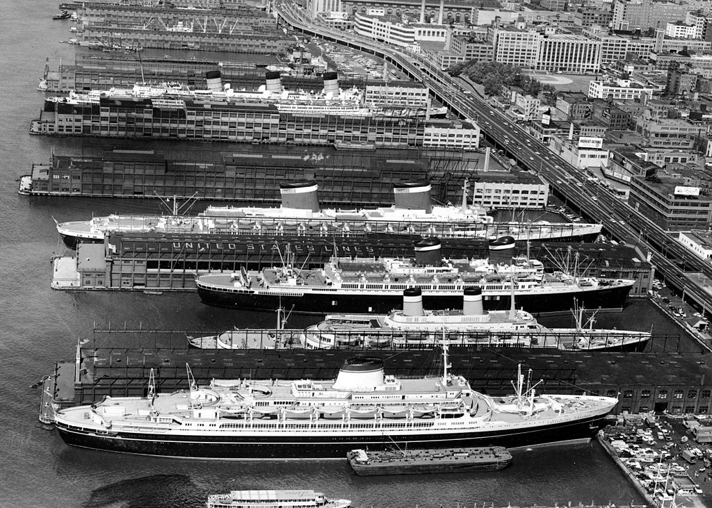
Old aerial maps and historical photographs show New York City’s waterfront tightly wrapped in piers stretching out over the water. By about 1840, more passengers and cargo were coming through the port of New York than all other major harbors in the country combined. And by the 1890s, New York Harbor was one the busiest port in the world.
About a century later, the city’s industrial backbone had shifted away from the rivers, the Hudson and East river warehouses were abandoned and many of the city’s piers became obsolete. Hudson River Park was built in 1998 on the remnants of New York’s post-industrial riverfront, where once-thriving piers were abandoned and New Yorkers were cut off from the water. “Unless you were coming off a ship or taking cargo off a ship, nobody went to the waterfront,” says Madelyn Wils, president and CEO of the Hudson River Park Trust, which runs the park.
Baltimore was the first city on the east coast to reinvent its waterfront. In 1964, the city put forward a vision to reconnect with its waterfront by wrapping the old harbor with a ring of vibrant public spaces connected together by a waterfront promenade. Fifteen years later, the revived Inner Harbor had become a front yard and a main street for the entire city. “Why couldn't New York do that?” says Wils.
/https://tf-cmsv2-smithsonianmag-media.s3.amazonaws.com/filer/da/4f/da4fd803-2c24-46ce-910e-aef4c8a05b98/3l1a9241.jpg)
/https://tf-cmsv2-smithsonianmag-media.s3.amazonaws.com/filer/70/4e/704ebd4e-a906-4716-a335-1b18c9a4afdd/3l1a9052.jpg)
/https://tf-cmsv2-smithsonianmag-media.s3.amazonaws.com/filer/e6/41/e641aaca-b139-410f-8781-af755bd30849/3l1a8770.jpg)
/https://tf-cmsv2-smithsonianmag-media.s3.amazonaws.com/filer/32/39/32399704-ff82-4e69-914b-2b109c0d734a/3l1a9274.jpg)
/https://tf-cmsv2-smithsonianmag-media.s3.amazonaws.com/filer/01/03/01031962-ed1c-4a55-9ea7-027f09c8d6c8/3l1a9359.jpg)
/https://tf-cmsv2-smithsonianmag-media.s3.amazonaws.com/filer/36/41/3641ec1e-10f6-4d60-af93-7dd6e377fe9d/3l1a9456.jpg)
/https://tf-cmsv2-smithsonianmag-media.s3.amazonaws.com/filer/e2/af/e2af1b33-3e54-4609-81c2-db063ab7c00b/3l1a9709.jpg)
Extending 800 feet into the water, Pier 26’s landscaped deck takes you on a short walk through the five different native ecological zones—a woodland forest, coastal grassland, maritime scrub, rocky tidal zone and the Hudson River—that predated the construction of all piers. Moving through the woodlands, planted with ferns, bluestem grass and beach plum, you break through a canopy of trees and into the coastal grassland, which mimics what the shoreline once looked like. As you get closer to the water, the landscape slowly shifts to the prickly pear cacti, pines and grasses that make up the first line of defense against rising tides and coastal flooding. Crossing through the so-called maritime scrub, punctuated by a sports court and a pair of outdoor swings facing the river, the journey culminates into a human-engineered rocky tidal marsh dubbed the Tide Deck.
“We were looking not just at the fauna but also the flora that palette could attract,” says Lucinda Sanders, CEO and partner at landscape architecture firm Olin, who worked with ecological consultants Biohabitats to build a diverse and accurate representation of the pre-settlement era.
Here, at the end of the pier, the walkway splits across two levels. The first is a public walkway that juts out from the pier’s original edge, rises above the water and boomerangs back around, leaving a triangular void in the middle. The second deck descends into that very void and hovers over a manmade salt marsh—with native shrubs, wetland grasses and 1,300 granite boulders—designed to flood at high tide.
To build the rocky tidal marsh, the architects brought the boulders from upstate New York, worked with marine and structural engineers to slot them into the water one by one, and carved them to simulate tidal pools for marine creatures. The rocky edge helps break the waves and ferries’ wakes, but it also simulates the kind of edge we might have seen in its natural state, just a little further into the river than usual. “It's not intuitive to build something like this 800 feet out onto the river,” says Sanders. “You would find a condition like that at a river's edge, not into the river.”
While the upper part of the deck is open to the public, the lower part is reserved for educational purposes and ecological programming. But the visual cues afforded by the cantilevering walkway offer learning opportunities for everybody who fancies a walk to the end of the pier. Come at midday and you will see the rocky marsh exposed, sparrows flocking in the tidal pools. Come back at sunset, and only the tallest boulder will peek out from the water, seagull perched on top.
“People don't recognize the Hudson is tidal, that's our connection to the ocean,” says Margie Turrin, an education coordinator at Columbia University's Lamont-Doherty Earth Observatory. “Being able to see the flooding and ebbing will be critical.”
Recreating something that nature would have spent years sculpting isn't quite the same, but “by allowing nature to finish what humans started, they've left an opportunity for research,” says Turrin. Two weeks after the opening of the park, the marsh's nooks and crannies were already populated by algae, barnacles and anemones, and they will continue to evolve. “We're going to see mussels, oysters,” adds Turin, “more of an interplay between birds and fish.”

The 315-mile-long Hudson River, extending from the Adirondacks to the tip of Manhattan, boasts distinct habitats that, starting from the north, progress from fresh, to brackish, to salty. Nearly half of the river is considered a tidal estuary—where salt water from the ocean mixes with freshwater from the river’s northern tributaries. Pier 26, in fact, sits in a 400-acre, nationally designated estuarine sanctuary with a management plan that focuses on providing education, research and habitat enhancement. “It's the only estuarine sanctuary in New York State and one of the few urban ones in the world,” says Carrie Roble, vice president of the River Project, the Hudson River Park Trust’s educational and scientific department.
For nearly two decades, the pier's ever-crumbling foundations functioned as a marine field station for the River Project, until the original pier was demolished in 2008, and the River Project moved up to Pier 40. “[The Tide Deck] provides new opportunity for research and monitoring that we will thoughtfully include community and students in,” says Roble, as we descend towards the rocks and pause on the lower walkway, halfway between land and water. This intertidal zone, where many animals thrive away from predators, is what inspired Roble to become an aquatic ecologist. “It's the forgotten zone of the coastal system, but it's so rich with not only animals, but also opportunity for research and monitoring,” she says.
Turrin, who develops and runs science education projects for K-12 and undergraduate students, is excited for her students to sample directly from the water. “You can’t really understand something you can't access,” she says. “And if you can put people in it, even better.”
In addition to educating people about the many and varied ways the ecosystem benefits humans, Pier 26 is also a study tool for climate change and resilience. “Having something that is actually connected and intended to flood on a regular basis, rather than a barrier, which has been traditionally our relationship with water, gives us a chance to think about climate change and how we're going to be responding to climate change,” Turrin says.
/https://tf-cmsv2-smithsonianmag-media.s3.amazonaws.com/filer/3a/ab/3aaba46d-c915-42d2-ac5a-174ae5460515/vh000-pier_57_ny-_camera01-_exterior_dusk-06.jpg)
/https://tf-cmsv2-smithsonianmag-media.s3.amazonaws.com/filer/bb/d9/bbd93e2f-94b2-4df5-bce2-c18962136fa4/ne_aerial.jpg)
/https://tf-cmsv2-smithsonianmag-media.s3.amazonaws.com/filer/4e/8a/4e8ae858-1258-470b-8274-59284f46ccf2/mg-004.jpg)
Like any city on the water, New York City is no stranger to sea levels rising and the importance of building a resilient waterfront. And while the city's pier renaissance, propelled by the birth of Hudson River Park in the early 2000s, is more rooted in economics than sustainability, it is indicative of the city's desire to reclaim its relationship to water.
The first stretch of Hudson River Park opened alongside Greenwich Village in 2003. Pier 45, or Christopher Street Pier, was given a new lease of life together with Pier 46 and Pier 51. A second wave of major redevelopments came in 2010, when the park expanded north, with the opening of Pier 64 and three adjacent piers. Around the same time, the famous Pier 25 opened its doors. “Our most active pier,” as Wils calls it, it features a miniature golf course, sand volleyball courts, a children’s playground, a boating hub and sweeping views of the Statue of Liberty and Ellis Island.
Some piers, like 79 and 81 have preserved their relationship to the transport industry—one is a bustling ferry terminal, the other has offered luxury yacht rentals for 35 years—but for the most part, recreation and entertainment remain at the core of the piers’ programming. “This is New York City, one has to insert program into a park that is not just about the ecology,” says Sanders, referring to Olin's varied design for Pier 26, which features a sports field, seating aplenty and the City Vineyard restaurant and wine bar.
Designers of resurrected piers, however, are paying more and more respect to ecology, while still recognizing the economic advantages the sites offer. On the East River, which had over 40 piers in operation by the late 1950s, Brooklyn Bridge Park was born in 2010. At the southern edge of the Park’s Pier 1, a salt marsh is planted with native plant life and nestled within a salvaged granite seating area. On pier 4, completed in 2014, an urban beach incorporates innovative structures designed by ECOncrete to mimic natural tidal pools.
Back on the Manhattan side, the East River Waterfront Esplanade opened in April 2019, with an eco-park at Pier 35. Designed by SHoP Architects, with landscape architecture design from Ken Smith Workshop, the pier is home to Mussel Beach, which was inspired by the pre-industrial East River shoreline and provides habitat for mussel growth akin to the work being done by the Billion Oyster Project.
The East River has its fair share of privately-owned ventures like the 2018 glass shopping pavilion on Pier 17. On the Hudson River, the Chelsea Piers Sports & Entertainment Complex has been operating since 1995, transforming three long-neglected piers (once home to the famed White Star and Cunard lines) into a premier center for recreation and waterfront access. And then there's Pier 57, just west of the Meatpacking District. The revenue-generating destination will soon serve as offices for Google, the anchor tenant, as well as a public marketplace, a classroom for the River Project, and a landscaped rooftop park accessible to the public. "Even though it's a commercial pier that pays rent, we made sure there's over three acres of public space on top of the pier,” says Wils.
Opening late 2021, Pier 57 isn't the last pier development in sight in Hudson River Park. Two blocks south, Little Island is well underway at Pier 55. Designed by Heatherwick Studio, the architects behind the Vessel in Hudson Yards, Little Island is the very pricy, very ostentatious product of an architecture competition held by Hudson River Park Trust and entertainment mogul Barry Diller. Raised atop 300 concrete columns shaped like champagne glasses, the $250-million pier will feature a maritime botanic garden and an outdoor amphitheater.
Yet another block south of that, is Gansevoort Peninsula. Built on solid ground as opposed to a pier, Gansevoort will be developed into a large green oasis, complete with a resilient beach and another salt marsh.
As for Pier 26, the upland area immediately east of it will eventually include a science-themed playground designed by Olin. A planned estuarium—a research and education center to be designed by Rafael Viñoly Architects—is in its fundraising stage.
“We've been working on waterfronts for 40 years in our practice,” says Sanders from Olin. “A lot of it is economic, but also people have been drawn to the water. Whether it's spiritual or physical, those connections are super important.” Sanders talks of a desire to “humanize the edge” by designing softer thresholds between land and water—something that Pier 26 is doing by providing a rocky wetland that embraces the tide and offers itself up for wildlife research.
In the end, it’s about going back to our roots.
“We're reconnecting with the truth that we're islanders,” says Roble. “The water defines the city and it actually defines our daily lives, but many are just not aware of it.”
/https://tf-cmsv2-smithsonianmag-media.s3.amazonaws.com/accounts/headshot/Elissaveta_M._Brandon.jpeg)