Maps of the Future
A 1989 prediction about portable GPS devices was right on the money
/https://tf-cmsv2-smithsonianmag-media.s3.amazonaws.com/accounts/headshot/matt-novak-240.jpg)
/https://tf-cmsv2-smithsonianmag-media.s3.amazonaws.com/filer/map-470x251.jpeg)
Remember paper maps? They used to be the only game in town. But the 2000s (the aughts? have we named that decade yet?) saw a radical shift in the way that befuddled drivers could figure out how to get from point A to point B. Suddenly, global positioning systems (GPS) became affordable enough that the average consumer could buy stand-alone units for their cars and GPS technology began showing up in smartphones (though often early smartphones were simply using cell tower triangulation). It wasn’t very long ago that consumer GPS devices were super-futuristic technology.
The 1989 book Future Stuff by Malcolm Abrams and Harriet Bernstein looked at the various technologies that people might see in the 1990s and beyond. The book assigned an estimated year, an estimated price and gave the odds as to whether we’d see this technology at all. One of the technologies was “car video” navigation, as well as satellite navigation. The “video navigation system” relied on a rather primitive design—a “casette-tape data source” that allowed you to input an “electronic road map” on a video monitor mounted on your dashboard. The satellite navigation described in the book is much closer to what we actually see today:
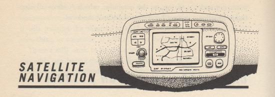
The video navigation system, which we’ll see introduced early in the decade, should be passe by the end of the decade. It will be replaced by satellite navigation, an amazing system that will be able to pinpoint your car’s location anyplace in the world, alert you to an upcoming traffic jam and show you all alternate routes, warn you of approaching bad weather, and so on. Your car will be bouncing signals off satellites in space just like the most advanced communications systems.
Japan’s Nissan Motor Company is spearheading the technology with its Satellite Drive Information device. Your location will be shown on your car’s computer display screen, using Nissan’s Global Positioning System. Forget video road maps and memory banks. The picture on your screen will be the real thing transmitted via satellite. The display screen will even tell you where to make turns and also measure distances (to the next intersection or to your final destination).
Satellite navigation is going to make it difficult for someone even with the worst sense of direction to get lost.
So when did they think this technology would finally arrive? The authors predicted that it had a 70% chance of becoming a reality by 1998 and early models would cost $2,500 (about $4,340 adjusted for inflation). That prediction turned out to be fairly accurate. In 2000, a simple portable GPS device—which could indicate your current location—sold for $699. But the top-of-the-line portable GPS devices, which could provide driving directions, cost $2,799.
/https://tf-cmsv2-smithsonianmag-media.s3.amazonaws.com/accounts/headshot/matt-novak-240.jpg)