This Magnetic Map Shows Earth as You’ve Never Seen It Before
Behold a new, super high-res view of Earth’s magnetic field
/https://tf-cmsv2-smithsonianmag-media.s3.amazonaws.com/accounts/headshot/erin.png)
For decades, satellites have enabled people to peer back at their planet, giving a once unthinkable perspective to what’s going on below. These days, however, these views have become so common most aren't surprised at new satellite maps—unless, that is, it shows Earth’s magnetic field.
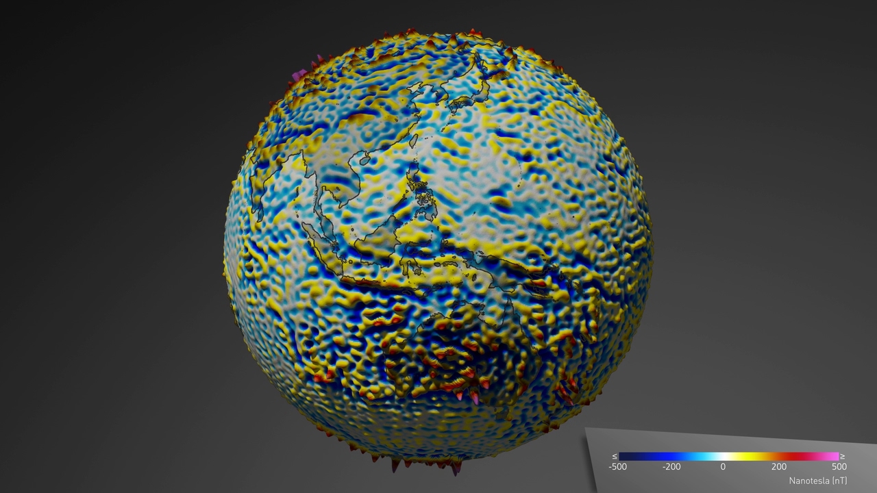
As the BBC’s Jonathan Amos reports, a new map does just that. It was generated using data from the European Space Agency's Swarm mission, which is dedicated to studying Earth’s magnetic field from space. Using a trio of identical satellites, Swarm measures magnetism in Earth’s core, mantle, crust, oceans, ionosphere and magnetosphere. It’s hoped that the mission will yield new information about Earth’s magnetic field and why it’s weakening.
Few are aware of Earth’s magnetic field on a daily basis—it’s impossible to see or feel without the right tools. But it’s there every day, and scientists think it’s changing all the time. Geomagnetic reversal (a process during which Earths’ magnetic poles flip position) has happened multiple times during the planet’s long history. Scientists suspect that it’s in progress now, and Swarm is part of their attempt to figure out what’s happening with the field.
As Amos explains, this latest satellite is more sophisticated than past iterations and can view Earth’s magnetic field in higher resolution than ever before. Using legacy information from past satellite missions, scientists hope to use it to map the planet’s magnetism in the greatest detail yet.
So what does the new map, which uses data from Swarm and its predecessor, Champ, reveal? A lot—in a release, ESA calls it “the highest resolution map of this field from space to date.”
The map shows magnetic stripes—places that show an alternating pattern of normal and reversed polarities—along the ocean crust. These stripes are thought to been generated as rock cooled at different points in Earth’s magnetic history and are considered a kind of recording of Earth’s many polar reversals. As new crust is produced in Earth’s mid-oceanic ridges and the seafloor spreads, they move in recognizable, stripe-like patterns.
You can also spot magnetic anomalies—places with unusually high amounts of magnetism—on the map. One such anomaly is in the Central African Republic. If you use a magnetic compass while standing over the Bangui Magnetic Anomaly, it will wig out due to the huge magnetic field. It’s still not known just why Bangui is home to such an extreme magnetic anomaly, but it’s possible it happened when an iron-rich asteroid bashed into the area millions of years ago.
In the future, Amos reports, scientists will use the information to update the World Digital Magnetic Anomaly Map, the current gold standard in magnetic maps. ESA scientists say it’s a chance to one day understand what’s up inside Earth’s crust—a place scientists can’t study easily due to logistics, including the fact that so much of it is located underwater.
Sometimes it helps to have a different perspective, and the new magnetic map promises to give scientists just that. For the rest of us, it’s a chance to see Earth in a new light—a reminder that though we can’t see or even feel Earth’s magnetic field, it’s with us every day.
/https://tf-cmsv2-smithsonianmag-media.s3.amazonaws.com/accounts/headshot/erin.png)