The DC Derecho of 2012
A devastating storm swept through Washington Friday night. By Saturday morning we were all left wondering, “what in the world had happened?”
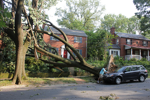
One of the hundreds of trees lost to Friday night’s derecho (courtesy of flickr user woodleywonderworks).
The Washington, DC area has seen its fair share of destructive storms–we get hurricanes, tornadoes and even the rare snowpocalypse. But on Friday night we got hit with another type of storm–one that I’d never heard of–called a derecho (pronounced ”deh-REY-cho”).
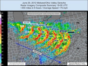
The storm swept through the area late Friday evening, bringing an incredible amount of thunder and lightning, winds up to 80 mph and sheets of rain. By morning, hundreds of trees had been blown down, millions were left without power and several people were dead. Netflix, Pinterest and Instagram had all been taken down by Amazon server outages caused by the storm. The Smithsonian Folklife Festival had to shut down for a day to clean up the mess. We were all left wondering, “what in the world had happened?”

Friday’s derecho originated near Chicago and raced southeast towards Washington, DC (courtesy of NOAA)
The stifling heat wave that we’d been suffering through, which had stretched from the Midwest through the mid-Atlantic to the Southeastern United States and brought temperatures in excess of 100 degrees Fahrenheit, was to blame for the fast-moving band of thunderstorms. The Capitol Weather Gang explains:
As this stifling air bubbled northward, clashing with the weather front draped from near Chicago to just north of D.C., thunderstorms erupted. They grew in coverage and intensity as they raced southeast, powered by the roaring upper level winds and fueled by the record-setting heat and oppressive humidity in their path.
The coverage and availability of this heat energy was vast, sustaining the storms on their 600 mile northwest to southeast traverse. The storms continually ingested the hot, humid air and expelled it in violent downdrafts – crashing into the ground at high speeds and spreading out, sometimes accelerating further.
Though unfamiliar to those of us here on the East Coast, derechos occur more commonly in the Corn Belt, which runs from Mississippi into the Ohio Valley, but even there they are relatively infrequent. They can wreak their havoc at any time of the year but are most likely to occur during May, June and July. Derechos get their starts in curved bands of thunderstorms called “bow echoes,” which are perhaps better known for their ability to spawn tornadoes. But instead of rotating cells of winds, derechos blow and travel in straight lines.
Derechos have a long history here in the United States. The term “derecho” was coined by University of Iowa physics professor Gustavus Hinrichs in an 1888 paper in the American Meteorological Journal in which he illustrated the path of such a storm that had crossed over Iowa on July 31, 1877. The storm’s straight path across the state gave Hinrichs the inspiration for the storm’s name–”derecho” means “straight” in Spanish. But path alone isn’t quite enough for a storm to qualify as a derecho; wind speeds must also reach a minimum of 57 mph.
Given that derechos are associated with warmer weather, could they become more common as the United States heats up due to climate change? Tom Kines, senior meteorologist at AccuWeather.com, told the Guardian: “If indeed we are seeing global warming, then it will certainly increase the risk of something like this happening again.”
/https://tf-cmsv2-smithsonianmag-media.s3.amazonaws.com/accounts/headshot/Sarah-Zielinski-240.jpg)

/https://tf-cmsv2-smithsonianmag-media.s3.amazonaws.com/accounts/headshot/Sarah-Zielinski-240.jpg)