These Maps Show the Severe Impact of Hurricane Katrina on New Orleans
Where does the city stand now, compared to where it was ten years ago when the storm hit
In late August of 2005, Hurricane Katrina barreled across the Gulf of Mexico and onto the southeastern United States, unleashing a fury of destruction in its wake. People around the world watched as the densely populated city of New Orleans endured catastrophic damage, a devastating combination of natural fury and human error. Today, following ten years of rebuilding, reshaping and development gone by, the Big Easy is a changed city. The maps in the above interactive explore the shifts that have taken place in this transformative decade.
When Katrina made landfall at 6:10 am CDT on August 29, it brought along with it 130-miles-per-hour winds, 10 to 12 inches of rainfall, and a storm surge approaching 30 feet. At that point, it was a Category 3 hurricane; the city’s levees, which were in disrepair and ill-suited to withstand the storm, collapsed under the pressure of heavy winds and rains. Water from the Gulf of Mexico and Lake Pontchartrain gushed into the Crescent City. At one point 80 percent of New Orleans, where the average elevation is six feet below sea level, was flooded. Some places were submerged in 10 feet of water.
Although most residents had evacuated, about 150,000 people, largely low-income or disabled residents, remained in the city. It is estimated that 986 people died in New Orleans – that’s more than 50 percent of the total fatalities caused by Hurricane Katrina. And those who survived lived in squalid conditions in the weeks and months following the storm. Tens of thousands of people were stranded in the city without access to electricity or potable water, and the United States faced a humanitarian crisis.
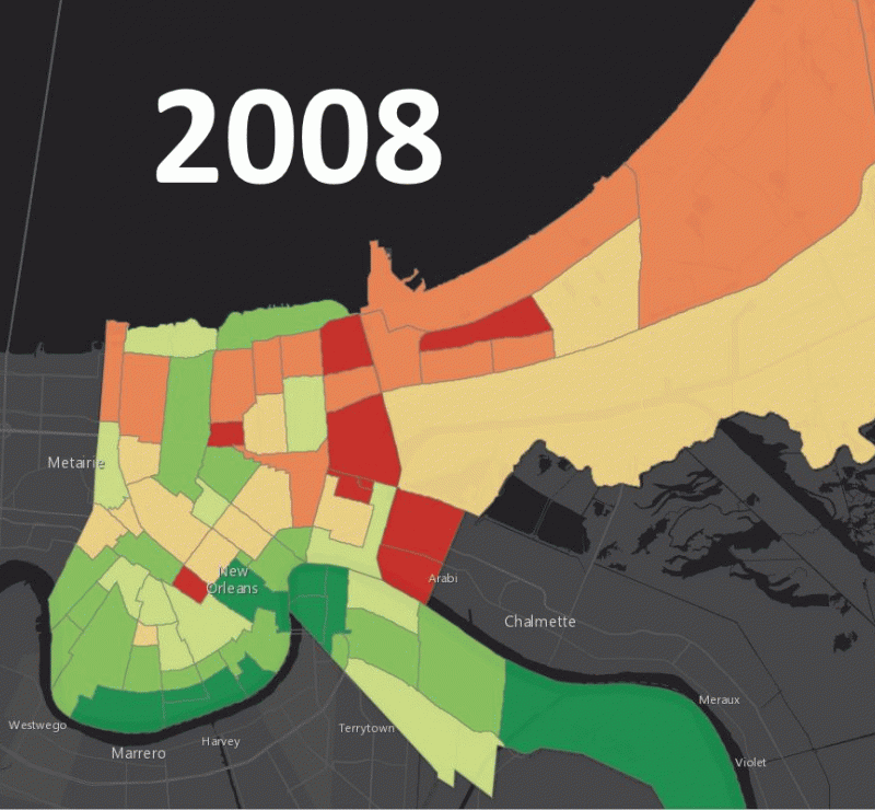
Since 2005, New Orleans officials and federal agencies have made efforts to restore the city to its pre-Katrina vitality, and now 40 of the city’s 72 neighborhoods have recovered 90 percent of their pre-Katrina population numbers. Residents report seeing progress in repairs of levees and improvements in attracting new business to the city. The aninated gif below shows the growth in neighborhoods where mail was being delivered from 2008-2015 -- orange indicates that 40 percent or fewer pre-Katrina homes received mail that year, green indicates that 90 percent or more received mail.
But consequences of the disaster linger. Poverty rates have risen to pre-Katrina levels and the city’s black population is shrinking. Yet, eight in ten residents report feeling optimistic about the city’s future.
/https://tf-cmsv2-smithsonianmag-media.s3.amazonaws.com/accounts/headshot/DSC_0154.JPG.jpeg)