The Colorado: America’s Most Endangered River
A new report points to drought, climate change and increased demand for water as the reasons the iconic river no longer reaches the sea
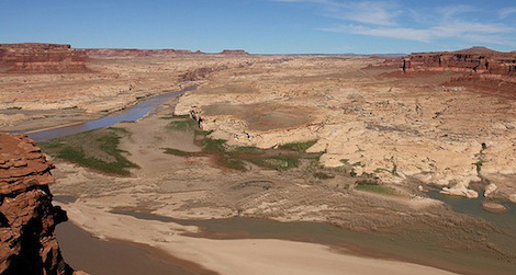
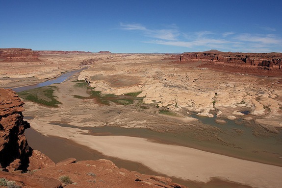
Drought and an increased demand for water have stressed the Colorado River, which flows nearly 1,500 miles through seven states and Mexico. Photo by Flickr user Alex E. Proimos
When Alexandra Cousteau, granddaughter of Jacques, recently went to Mexico to explore the southern terminus of the Colorado River, she found mud, sand and dust where water once raged. The expedition was videotaped for a short film (viewable below) produced in conjunction with Cousteau’s nonprofit, Blue Legacy, which raises awareness about water issues. The video was called Death of a River: The Colorado River Delta.
That title, it turns out, is an apt one: Today, the conservation organization American Rivers released its annual ranking of America’s most endangered rivers, and the Colorado topped the list.
The group cites outdated water management as the main malady attacking the Colorado’s health. “A century of water management policies and practices that have promoted wasteful water use have put the river at a critical crossroads,” a statement (PDF) released by the organization reads. “Demand on the river’s water now exceeds its supply, leaving the river so over-tapped that it no longer flows to the sea.”
<object classid="clsid:d27cdb6e-ae6d-11cf-96b8-444553540000" codebase="http://download.macromedia.com/pub/shockwave/cabs/flash/swflash.cab#version=6,0,40,0" height="338" width="600"><param name="allowFullScreen" value="true"/><param name="allowscriptaccess" value="always"/><param name="src" value="http://www.youtube.com/v/Z0oErFt5zk0?hl=en_US&version=3&rel=0"/><param name="allowfullscreen" value="true"/><embed allowfullscreen="true" allowscriptaccess="always" height="338" src="http://www.youtube.com/v/Z0oErFt5zk0?hl=en_US&version=3&rel=0" type="application/x-shockwave-flash" width="600"></embed></object>
At one time, the river emptied into the Gulf of California, between mainland Mexico and the Baja Peninsula. In fact, this river mouth can still be found on maps, including Google’s, because it’s supposed to be there. But a recent study (PDF) conducted by the Bureau of Reclamation (a division of the U.S. Department of Interior) determined that the entire river and its tributaries are siphoned off to meet the drinking, bathing and toilet-flushing needs of 40 million Americans throughout seven states, including Arizona, California, Colorado, New Mexico, Nevada, Utah, and Wyoming. It also irrigates 5.5 million acres of land and helps meet the electrical-power appetite of much of the West through hydro-power facilities. Nearly two dozen Native American tribes depend on it, and it’s the centerpiece of 11 national parks, most famously the Grand Canyon.
“Growing demands on the Colorado River system, coupled with the potential for reduced supplies due to climate change may put water users and resources relying on the river at risk of prolonged water shortages in the future,” the study authors write. “Ultimately,” they add, “the Study is a call to action.”

Low water levels at the Colorado River’s Hoover Dam, on the Arizona-Nevada border. Photo by Flickr user Remon Rijper
But what action is needed? Water conservation, water reuse and water augmentation–replacing water drawn from wells–the authors say. Specifically, landowners and municipalities must boost their agricultural, municipal and industrial water conservation agendas, as well as improve their energy water-use efficiency. Solutions for the most challenging regions include finding ways to import water, reuse waste water and desalinize ocean and brackish water.
Scientists acknowledge some solutions they’ve looked into are easier said than done and that not all are viable in every region. For instance, options like importing water to Southern California via submarine pipelines, water bags and icebergs (PDF), along with watershed management techniques like weather modification (aka cloud-seeding) are a bit pie-in-the-sky.
The Colorado isn’t the only endangered river, by far. Georgia’s Flint River, the San Saba River in Texas, Wisconsin’s Little Plover River, the Catawba River in the Carolinas and Minnesota’s Boundary Waters were all also red-flagged by American Rivers this year.
The challenge for all of these rivers, including the Colorado, only grows in the future. Climate-change-induced drought is working against them. American Rivers notes (PDF) that changes to climate are expected to reduce the Colorado River’s flow by as much as 10 to 30 percent by the year 2050. It could leave yet more sand and mud behind, making parts of the American West and Southwest even more parched.