Frozen in Time
Glaciers in the Pacific Northwest have recorded hundreds of years of climate history, helping researchers plot how quickly the planet is warming
/https://tf-cmsv2-smithsonianmag-media.s3.amazonaws.com/filer/Frozen_LifeintheField_388.jpg)
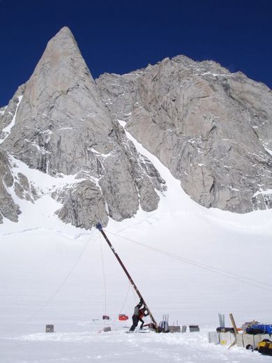
Even though Mount Waddington is the tallest, coldest mountain in British Columbia, some scientists say it is just not cold enough. Cold enough, that is, for its glacial ice to preserve centuries of climate history intact. To compare today's climate to that of the past, ice cores have been extracted from glaciers in the Arctic, Antarctica, Greenland and some mountains. But most experts doubt that untainted cores can come from the Pacific Northwest, where warm summer months can melt the ice and jumble its layers of ice and dusty debris. A team of climate researchers spent six days this past July beneath this snow-covered summit recovering information they hope will prove otherwise.
Geologist Doug Clark from Western Washington University in Bellingham, Washington, and glaciologists Eric Steig from the University of Washington at Seattle and Erin Pettit of Portland State University say the layers of ice may have captured 200 to 1,000 years' worth of chemicals, minerals, dust, charcoal—even volcanic ash. If the layers are preserved intact, the researchers hope to reconstruct a record of the region's climate. The scientists also measure how fast the glacier is traveling. Such information could help researchers predict what is in store for the Pacific Northwest, including whether its glaciers will survive as the earth continues to warm. As Clark says, "If we have a better idea what happened in the past, we have a better idea what might happen in the future."
The researchers will extract much of the information they need from the glaciers by drilling ice cores—ideal geologic time capsules. Layers of time can typically be seen as varied shades of blue and white stripes of snow compacted into ice. But only through chemical analysis can the scientists differentiate layers of summer dust from winter ice. The amount and type of dust will tell more of the tale: for example, dense layers of dust can indicate an extremely dry summer, and carbon or acid—evidence of burned wood and ash—may reveal past forest fires or volcanic eruptions. The scientists are also looking at the ratio of light to heavy isotopes of oxygen and hydrogen to determine past temperatures: heavier isotopes tend to fall out of cold air. Says Clark: "Ice cores are arguably the most direct quantitative measures of past temperatures and precipitation."
This alpine ice also creates and supports unique ecosystems. Glaciers whittle out crevasses and valleys and push up earth and rock, forming hills and mountains. Certain algae grow on ice, which feed bugs such as ice worms that can survive only on year-round snowpacks. Birds living in such cold environments depend upon these creatures to survive. Glaciers reflect heat, create pockets of fog (from which some alpine plants derive moisture) and release cold water into rivers. "If the glaciers dry up in the Northwest, we will have a hard time keeping some salmon runs," says Pettit. Water from glaciers and snowpacks, she says, also provide hydraulic power and fresh water. "The city of Seattle gets its entire water supply from two snowpacks."
But glaciers in the mid-latitudes are very sensitive to climate changes. As the earth warms, more precipitation falls as rain rather than snow, and this can dissolve packs of ice and snow. "That is when you can really kill off a glacier," says Pettit. "It's happening in the Cascades already." Glaciologist Mauri Pelto, director of the North Cascades Glacier Project, in Dudley, Massachusetts, has seen the effects of the increase in the ratio of rain to snow: of the 47 glaciers in the region his research team has observed since 1984, forty-two have lost 20 to 40 percent of their total volume and five have disappeared entirely. And, he says, the greatest amount of water flow in the streams and rivers used to be in the summer but is now in the winter. Because the ground is already saturated by then, says Pelto, "the flood hazard is worse."
What makes a glacier a glacier and not just a big patch of ice? Motion. A glacier doesn't always travel at a glacial pace; its rate of movement depends on how cold it is. Pettit explains that glacial ice is like molasses: the warmer it is, the more fluid it is. "Glaciers in the Arctic flow slowly, whereas many glaciers in the Northwest and Alaska slide quickly at their base, lubricated by meltwater." One sure sign that an ice sheet is a glacier is if it has crevasses forming on the surface, caused by ice moving downslope. A glacier in Greenland has been tracked traveling about ten miles a year. "You would probably not want to spend too much time on a glacier like that," says Pettit. "A crevasse might open up underneath you."
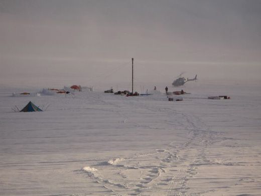
Dropped off by helicopter on Mount Waddington, Steig and Clark's research team used GPS to measure the glacier's speed and melting rate and used radar to scan its depth. Guided by Bella Bergeron, a professional driller from the University of Wisconsin at Madison, most of the crew members drilled in the evenings, when the ice was colder. The core, brought up in three-foot pieces, was then flown back to a lab at the University of Washington at Seattle. To their surprise, the core was almost clear rather than banded blue and white, and at the bottom of their borehole they found a melt layer. Only in the lab will they be able to tell whether water has percolated through the ice layers and scrambled the core's data.
The researchers hope they will be able to use this core to fill a gap in the climate record. Other Pacific Northwest samples have been taken from Mount Logan, in Canada, and mountains in Alaska, but "we haven't had a good climate record this far south," says Pettit. Clark says sampling such mid-latitude glaciers is urgently needed. "They are melting away in a big hurry, and these records won't be around much longer."


