Biking Ecuador’s Spectacular Avenue of the Volcanoes
Home to a string of high peaks, including 20,564-foot Chimborazo, the area offers some of the finest cycling, hiking and adventuring country anywhere
/https://tf-cmsv2-smithsonianmag-media.s3.amazonaws.com/accounts/headshot/Off-Road-alastair-bland-240.jpg)
/https://tf-cmsv2-smithsonianmag-media.s3.amazonaws.com/filer/20130304011112Quilotoa2.jpg)
Ecuador has done a tremendous job of preserving its wild places. More than 20 percent of the country is protected within more than 30 parks and reserves, some of them quite vast. In a nation as compact as Ecuador, what this translates into for travelers is beautiful national parks, one after another, like stepping stones through some of the world’s most astounding scenery.
In the Andes, many of the giant volcanoes have their own namesake national park, and from south to north one finds Sangay, Chimborazo, Llanganates, Iliniza, Cotopaxi, Antisana and Cayambe-Coca, to name several. These protected areas essentially demarcate what is known as the Avenue of the Volcanoes, or Volcano Alley—and it’s this route that I followed on my final march northward, toward Quito and the finish line of the international airport.
Here, my adventure finally came alive. I had spent weeks floundering—either resting my injured Achilles tendon or, later, undergoing anti-rabies treatment at a hospital following an unpleasant dog encounter. During this time, I often lay in bed, read books, iced my heel and wished for the freedom of the hills. But I finally fell into the familiar rhythm of bicycle touring as I pedaled uphill from Puyo to Baños, a 3,500-foot climb that leads from the Amazon basin to one of the most esteemed tourist towns in Ecuador—and, even better, to the foot of Tungurahua, the three-mile-high mountain that has been spewing smoke and ash for several months. Like most of the peaks along Volcano Alley at this time of year, Tungurahua hid within a ceiling of clouds, and I only caught a glimpse of the triangular peak one night in the light of the half moon when I peeked out my tent.
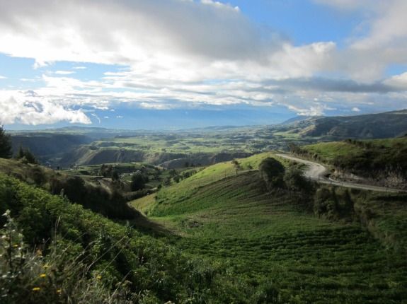
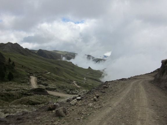
Though the Panamerican Highway bisects the Avenue of the Volcanoes, contriving routes to avoid this congested, smoggy artery brings one, as a matter of course, into some of the finest hiking, cycling and adventuring country anywhere. The land is hilly and green, and in places rugged and dangerous. I spent one afternoon ascending from the town of Pillaro into Llanganates National Park, home to the 10,792-foot Cerro Hermoso and, at the end of the long and difficult road, Laguna Pisayambo. The asphalt turns to dirt as the road steepens near the park entrance. The wind wails here, across treeless slopes, and cyclists and backpackers will find a cozy surprise—a refuge free for public use at the park entrance, at nearly 13,000 feet. I arrived at dusk, and two employees welcomed me, fed me and offered me the use of the hot water, the stove and a bed. But I chose to camp outside, and as the cold night came on, the lights of the city of Ambato 4,000 feet below flickered and shined like a million stars. Hidden in the darkness across the valley was Chimborazo’s 20,564-foot summit—often advertised as “the closest point to the Sun”—but I couldn’t see it, and never did, for it remained buried in clouds.
The next day I crossed the Panamerican Highway and headed west, for the much-loved but little-known Quilotoa-Sigchos basin, where I would spend a week exploring what might be the best cycling region in Ecuador. Right out of the town of Latacunga, the road goes up. To non-cyclists, this may sound like the worst of possibilities, but for me and many of my fellow cyclists, climbing is the reason we own bicycles at all. It’s on those uphill grades that we feel the heat of our own blood and the pace of our hearts. Climbing, perhaps, reminds us we’re alive, while million-dollar views take shape behind us. The road out of Latacunga ascends to some 13,000 feet before leveling off on a broad plateau of Andean tundra, then descends into a beautiful valley peppered with farmhouses and tiny villages, and a camping site called Posada de La Tigua. Here, the owners may try and talk you into taking a room for $35. Just camp. It’s $3.50, and you can watch the stars of the southern sky.
Onward, and the dramatic ups and downs, the friendly people, and the green hills make smiling out here as natural as breathing. In Zumbahua, a pair of video-journalists with a Quito-based cycling club, BiciEcuador, interviewed me and asked how I liked this area.
“The best of Ecuador,” I said.
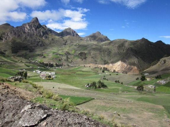
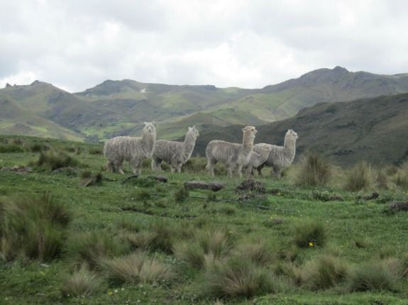
The pride and joy of this region is Lake Quilotoa. There is an adjacent town of the same name—a little community of indigenous people fortunate enough to be located on the edge of a dramatic crater. Here, travelers find a vista that makes the jaw drop and clunk against the sternum. Lake Quilotoa lies almost 2,000 feet below, and from these heights one can see the wind ripping the jade-green surface. Hikers popularly walk around the crater’s rim and may follow a trail down to the water’s edge. Here, some people camp, and I saw tents pitched on a beach straight below me. The quiet, dusty village of Quilotoa will probably become either one of the hottest, or one of the most underrated, tourist destinations in Ecuador. But in February it is a strange place. It is the slow season, and there are more hostels than tourists. Nearly every building, in fact, is a hostel—perhaps 15 of them—and more are being built. The town is clearly still developing its tourist infrastructure, for among all the hostels, and even in the large visitor’s center, there is no internet—no WiFi, and no plug-in connections. Several other establishments in Quilotoa, meanwhile, sell artisanal crafts and woven items of alpaca wool. Chilly gusts of wind sweep through the quiet streets and remind one that the elevation here is almost 13,000 feet. A pair of locally made alpaca gloves for $5 are a worthy buy.
Travelers who continue north from Quilotoa will find a downhill run to the friendly little village of Chugchilan, set on the slope of a steep and forested canyon. I took note of several hostels here, then continued through the village and took a side road uphill, following signs to a nearby cheese factory about 2,000 feet straight up, on a foggy mountaintop. The sign at the gate advertises the fact that this little operation uses Swiss technology. What? Flavorless Andean queso fresco isn’t good enough? (I actually quite enjoy the local mountain cheese.) I took away a pound of mozzarella and continued on a scenic loop that would bring me back to the village. “Did you manage to find the cheese factory?” a rusty red-faced man with a wide smile and a huge machete asked me. I had never seen him before, but he knew why I was here. He spoke with a strange accent, for he was among many folks here whose native language is the indigenous Quechua.
The people in these mountains were some of the politest I’ve ever met. Turkish hospitality is famous but can be overwhelming with insistent offers of tea and food. In the Andes, it’s all smiles and hellos and respectful distances. The children, especially, are marvels of manners and courtesy. They almost never fail to call out a friendly greeting, and they have several times proven incredibly articulate and thoughtful in helping me find my way through a complicated road network to my destination.
“It is 40 kilometers to Isinlivi,” a boy said to me one afternoon on a dirt road circling through the high hills. “On a bicycle, that means you’ll be arriving after dark. You must find a place to camp before then.” He was no more than 8 years old.
I stayed in Chugchilan at the Cloud Forest Hostel (reviewed here by Globe Trotter). They offered dinner of fried plantains, chicken and rice, but I cooked quinoa and eggs in my room and studied my map, mesmerized by its language of dots, lines and triangles. There were so many route options, so many villages, so many valleys—so much to see. I was only 60 kilometers from Quito as the condor flies, but I saw that I could have spent weeks traveling the dirt roads that crisscrossed this tiny region. I had only a week left, however. Where would I go? Was there time?
Ecuador may seem little, but it’s bigger even than the imagination.
Sign up for our free newsletter to receive the best stories from Smithsonian.com each week.
Planning Your Next Trip?
Explore great travel deals
Smithsonian magazine participates in affiliate link advertising programs. If you purchase an item through these links, we receive a commission.
/https://tf-cmsv2-smithsonianmag-media.s3.amazonaws.com/accounts/headshot/Off-Road-alastair-bland-240.jpg)