These Satellite Maps Reveal Rampant Fishing by Untracked ‘Dark Vessels’ in the World’s Oceans
Using satellite imagery and A.I., a new study finds about 75 percent of industrial fishing is not publicly tracked, and clandestine ships enter marine protected areas
/https://tf-cmsv2-smithsonianmag-media.s3.amazonaws.com/accounts/headshot/ChristianThorsberg_Headshot.png)
:focal(1417x1242:1418x1243)/https://tf-cmsv2-smithsonianmag-media.s3.amazonaws.com/filer_public/27/f4/27f4f707-7f88-47ec-bf12-231762e31f2f/gfw-visualization-fishing-vessels_sicily.gif)
It has sometimes been said that we know less about our ocean’s depths than we know about the moon. Now, a new study puts a twist on that old (and, some say, outdated) analogy, suggesting we know staggeringly less about our oceans’ surfaces than previously assumed.
For the first time ever, researchers have created a global map of human activity in the oceans and on coastlines, published last week in the journal Nature. By harnessing satellite imagery, GPS data and artificial intelligence, the team uncovered rampant, unregulated activity on the high seas, including untracked fishing vessels and a spike in offshore energy development.
“On land, we have detailed maps of almost every road and building on the planet,” lead author David Kroodsma, director of research and innovation at the nonprofit Global Fishing Watch, says in a statement. “In contrast, growth in our ocean has been largely hidden from public view. This study helps eliminate the blind spots and shed light on the breadth and intensity of human activity at sea.”

Crucially, the researchers found that between 72 and 76 percent of the world’s industrial fishing vessels are not being publicly tracked—and as a result, they haven’t factored into previous reports on ocean use.
To reach this conclusion, the team collected data from automatic identification systems (AIS)—devices used to convey a ship’s location and speed, essentially entering its voyage into public record.
Then, they analyzed two million gigabytes of satellite data from the European Space Agency, which painted a picture of ocean traffic between 2017 and 2021. The team trained an artificial intelligence model to identify vessels and other structures at sea. When comparing this map to the locations shown in AIS reports, the researchers discovered many more fishing vessels than anticipated.
This rampant number of “dark fleets”—so called because they are not connected to public monitoring systems and navigate undetected—were especially concentrated in waters around South Asia and Africa, and they immediately rang alarm bells for the researchers. Many vessels that participate in illegal fishing will deliberately sever their AIS connection.
/https://tf-cmsv2-smithsonianmag-media.s3.amazonaws.com/filer_public/19/cb/19cb2494-cc73-44be-b572-467acf2e14d3/gfw-visualization-all-activity_north-sea-with-key.gif)
“We had an idea that we were missing a big chunk of the activity happening in the ocean, but we didn’t know how much,” Fernando Paolo, a lead author of the study and a machine learning engineer at Global Fishing Watch, tells New Scientist’s Jeremy Hsu. “And we found that it’s a lot more than we imagined.”
For example, public data had previously suggested that the amount of fishing in European and Asian waters was similar. Instead, the new map shows a different story: Of every ten vessels in the ocean, seven are located off the coast of Asia, while just one is near Europe.
In the Mediterranean Sea, previous numbers had shown fishing on the European side to be ten times greater than that on the African side. But the new study suggests the amount of fishing on both sides is roughly the same.
“These previously invisible vessels radically changed our knowledge about the scale, scope and location of fishing activity,” writes Jennifer Raynor, an author of the study and a natural resource economist at the University of Wisconsin–Madison, in the Conversation.
Focusing on particular coastlines and geographies revealed potential hotspots for overfishing, as well as regional fishing strategies—from vessels off the coasts of Tunisia and Sicily gathering to bottom trawl near seabed canyons, to “dark” ships near Bangladesh following contours along the seafloor.
But this data can do more than uncover possible illegal fishing. “Vessel tracking could also transform environmental conservation efforts by revealing encroachment on protected areas,” write machine learning researchers Konstantin Klemmer and Esther Rolf in a perspective accompanying the paper. More than 20 vessels per week crossed into the Great Barrier Reef Marine Park, and over five per week entered the Galápagos Marine Reserve, according to the study.
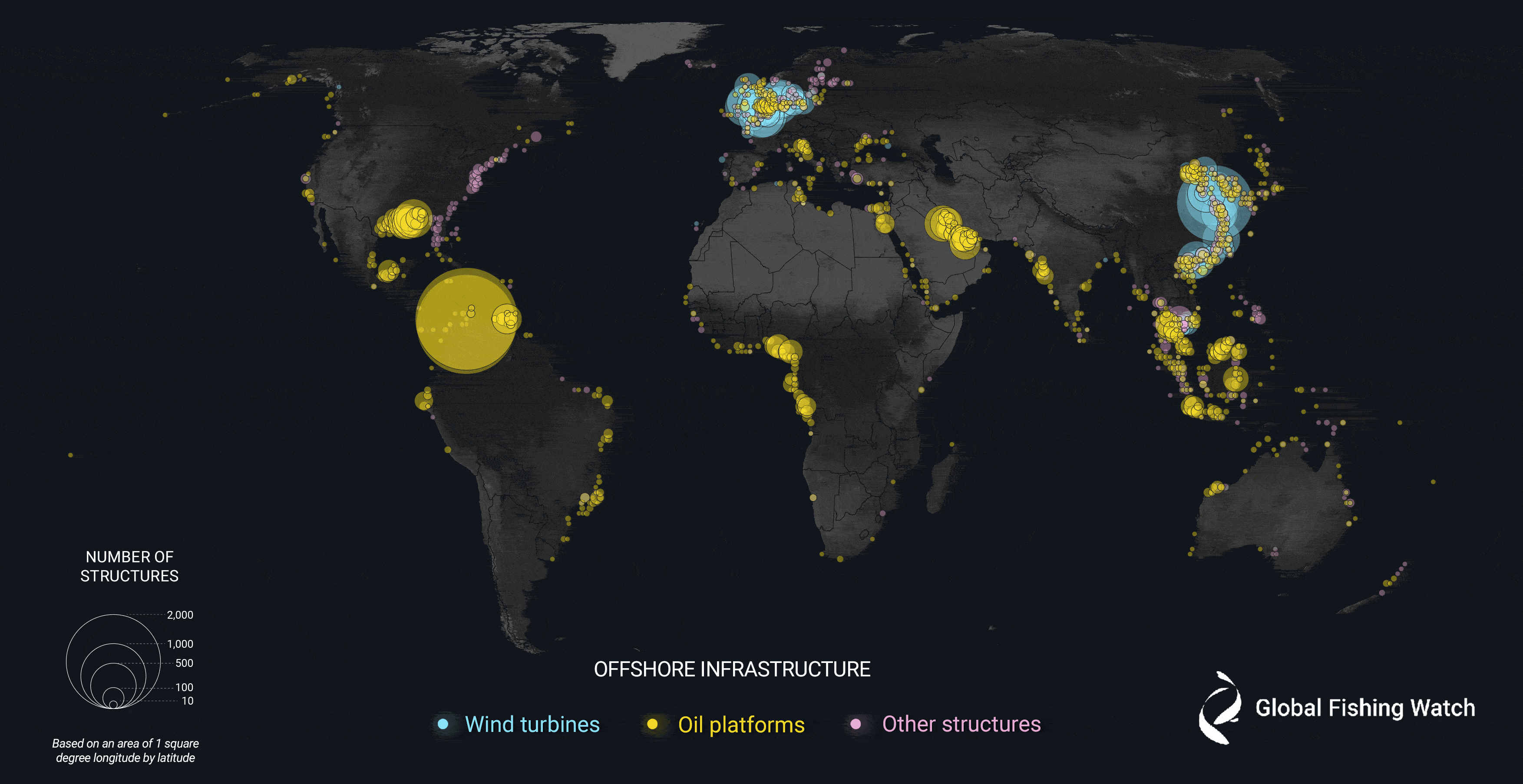
Beyond fishing, the maps also indicate that offshore energy has boomed in recent years—by 2021, wind turbines made up 48 percent of ocean infrastructure, compared to oil platforms’ 38 percent.
That more vessels and energy structures operate at sea than previously thought draws attention to the industrialization of the oceans, a process that some have coined the “blue acceleration.”
“The footprint of the Anthropocene is no longer limited to terra firma,” co-author Patrick Halpin, a marine geospatial ecologist at Duke University, says in the statement. “Our work reveals that the global ocean is a busy, crowded and complex industrial workspace of the growing blue economy.”
/https://tf-cmsv2-smithsonianmag-media.s3.amazonaws.com/accounts/headshot/ChristianThorsberg_Headshot.png)