This is the First Detailed Public Map of the U.S. Internet Infrastructure
The location of major cables was once a secret, but now researchers hope knowledge of it will spark conversations on how to keep the system safe
/https://tf-cmsv2-smithsonianmag-media.s3.amazonaws.com/filer/e8/9d/e89d016e-b6dc-4def-845e-0241250c2106/42-72709241.jpg)
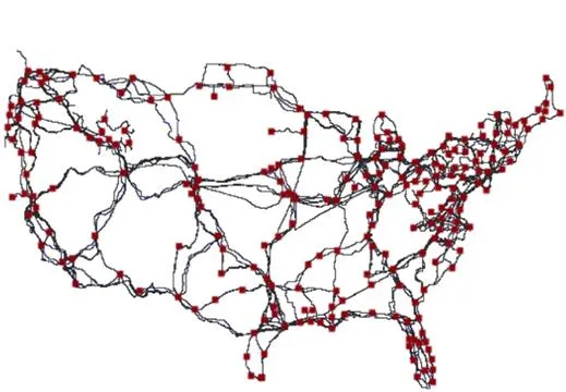
Although the internet is now a ubiquitous part of many people’s lives, it still can be tricky to think about as a whole, especially for those seeking to visualize it. Yet it is possible to map almost anything, including the internet. Computer scientists at the University of Wisconsin just released the first public map of the infrastructure that supports the heart of the U.S. internet.
For MIT Technology Review, Tom Simonite writes that computer scientist Paul Barford and his colleagues took four years to produce the map. He reports:
The map shows the paths taken by the long-distance fiber-optic cables that carry Internet data across the continental U.S. The exact routes of those cables, which belong to major telecommunications companies such as AT&T and Level 3, have not been previously publicly viewable, despite the fact that they are effectively critical public infrastructure, says Barford.
Mapping the internet’s infrastructure has been thought of as a security risk — which is why some previous attempts have been illegal. This time, however, the Department of Homeland Security has made the map and the data behind it available to the public through the project called Predict. “Our intention is to help improve security by improving knowledge,” Barford tells Simonite. “I think the map highlights that there are probably many opportunities to make the network more robust.”
Of course, other maps might be out there, just not public. The data in this map is drawn from public records created during the permitting process for laying cables that document the location for such cables. All in all, the picture is one of dark lines snaking across the U.S. and red boxes where those cables connect.
It’s not the only way to map the internet. Other efforts include visualizing the connections between websites or the grouping of IP addresses. And it may not be the most visually compelling, but its makers hope that this map of "the internet’s backbone" could help the infrastructure stay strong and secure. “A lot of discussions in Washington take place in a vacuum of empirical data,” says Tim Maurer, head of research at the Cyber Security Initiative of the Washington, D.C.-based think tank the New America Foundation. “I see this paper as part of a broader push to have more transparency around Internet policy issues that can inform a broader debate.”
Of course, the internet keeps changing. Cables are one way connections are made, but the future skeleton of the internet could be built of satellites.