This Mapping Tool Could Help Wilderness Firefighters Plan Escape Routes
Firefighters may soon get safety help from a new technology that assesses terrain and plots a course out
/https://tf-cmsv2-smithsonianmag-media.s3.amazonaws.com/filer/9a/06/9a06b504-0fbb-41e1-b7eb-16376fb2bcbd/forest_fire.jpg)
Wildland firefighting continues to be a dangerous and often deadly occupation. And as climate extremes cause the American West to dry out and catch fire more often, with more disastrous consequences, firefighters and researchers are looking to new technology to help them stay safe.
An important part of the preparation for firefighting teams is plotting out their safety zones and escape routes. But as anyone who’s hiked off-trail knows, it’s difficult to figure out the fastest way across varying terrain. So, researchers at the U.S. Forest Service and the University of Utah used maps constructed from satellite-borne LIDAR (Light Detection and Ranging, which works like radar except with lasers) to build a tool to evaluate possible escape routes and choose the most efficient one.
“I like to think about this as almost like a Google Maps for firefighters,” says Mickey Campbell, lead author of the study. “Google Maps has road information, traffic information, and stoplights and speed limits and stuff like that. We have slope, vegetation density, and ground surface roughness.”
Typically, each morning, before a fire crew goes out to fight a fire, they get briefed on both the day’s assignment—building a fire break, perhaps—and an “incident map” with escape routes that lead to already-blackened areas, where there’s no fuel left for the fire to burn, known as safety zones. If something unexpected happens, like if the fire changes, crews need to have a pre-identified escape plan. But much of the decision-making comes down to the moment, with crews directed by experienced supervisors, says Marty Alexander, a retired fire behavior research officer who still does work for the Canadian Forest Service.
“You’re not out there just willy-nilly walking around,” says Alexander. “It still comes down to basic woodsmanship and having good crew supervisors.”
But that can fail, and the results can be tragic. During the 2013 Yarnell Hill Fire in Arizona, 19 firefighters died when the fire cut off their escape routes. Sony Pictures’ Only the Brave, to be released October 20, will give moviegoers a dramatic depiction of the tragedy. In 1994, 14 died in Colorado’s South Canyon Fire when they tried to ascend a steep slope and were overtaken by the fire. Alexander and Bret Butler, a research mechanical engineer for the U.S. Forest Service who collaborated on Campbell’s study, both cite the South Canyon Fire as an influence on their work. That was the time, says Butler, when fire researchers realized they needed to quantify fire safety. He began analyzing heat transfer to see how big safety zones needed to be.
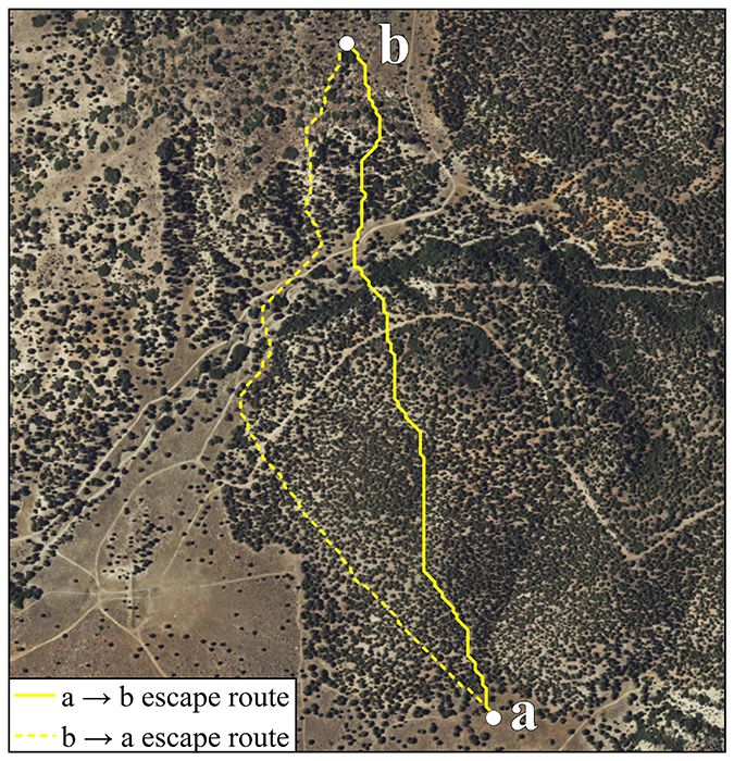
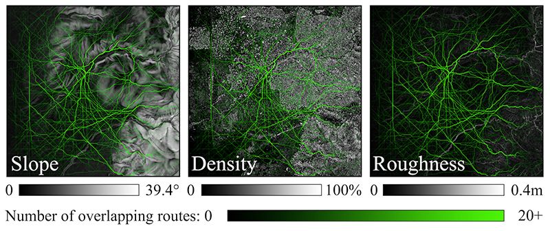
Campbell’s project is designed to give firefighters a new tool against wildland fires, to help avert these kinds of tragedies. The time it takes to traverse a wilderness can vary greatly, and firefighting guides suggest avoiding steep slopes, heavy vegetation, and loose or rough ground. The effect of slope has been measured to some degree, by Butler and others. Vegetation has been studied less, and ground texture basically not at all. Using LIDAR makes it possible to look at these in a quantifiable way previously impossible. The lasers bounce back from the landscape at a detail down to a few centimeters, discerning the difference between a smooth surface, a rocky one, and the thickness of the vegetation. Even the slope can be ascertained this way, by comparing elevation between points.
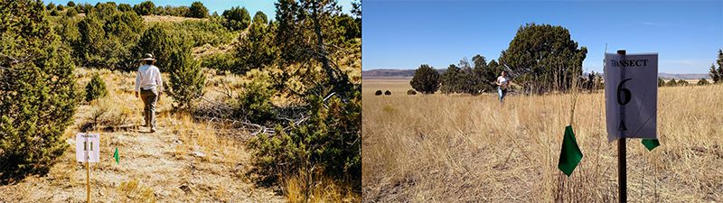
Campbell used LIDAR maps from opentopography.org to calculate slope, roughness and vegetation in Utah’s Wasatch Mountains. Then he sent 31 volunteers on 1,276 timed trips and compared their rates of travel based on those three variables. Some of the results were intuitive, though it still helps to quantify it. For example, slope had the biggest effect. Vegetation taller than 2 meters—above head height—obstructs travel less, and vegetation shorter than 15 centimeters had negligible effect. Even vegetation that did impede was often mitigated by paths running through it. The detailed information about how much each of these factors affects speed can help optimize escape routes—now, fire researchers can apply the relative speeds in different terrain to any LIDAR-mapped area, and the software will map out a path featuring the least possible combination of slope, roughness and vegetation.
Once you’ve got a LIDAR map of these factors—no easy task, points out Campbell, because not all of the U.S. has yet been mapped, and it takes a great deal of processing to assess each factor—you can turn that information into a quick, real-time route-finding tool, where firefighters plug in their location and destination and an algorithm quickly maps all possible routes and selects the fastest one, accounting for the terrain.
“A firefighter is not really in the same place for a long time at all,” says Campbell. “The idea would be to map out vegetation conditions on a broad scale, and that would have to be updated on a relatively frequent basis. But the actual route finding could be done almost instantaneously.”
There’s still plenty of work to be done before firefighters actually have this tool in their kit. Campbell and Butler’s study has shown that LIDAR maps can be measured to show the fastest possible route, based on the three variables they measured. But there are other variables to wildland travel, too, and while the collaboration with the forest service makes Campbell optimistic about implementation, the actual tool still needs to be packaged in a form that firefighters can use, like a mobile app.
However, there are still factors the technique can’t account for, points out Alexander, who did not work on the project. “Campbell’s study [had] a lot of great insights, and a great use of LIDAR and technology, but it’s not what I would consider a complete study,” he says. “Knowing what your travel rate would be is one thing, but you still have to have a prediction of what the fire’s going to do.”
Campbell’s LIDAR technique addresses relative speed—which route is most efficient—but not absolute, so you can’t tell how fast firefighters will actually be moving. The volunteers who walked the transects were not firefighters, and were not carrying packs (in an emergency, firefighters are taught to drop their packs). Sometimes, improvements to a route, like a trail or road or burned area, can offer speedy escape, but the LIDAR maps aren’t current enough to see that. It’s also less applicable for fires that take place in more populated areas, like the ongoing Northern California wildfires where the emphasis has been on evacuation rather than fire containment, and which may have enough roads to obviate the need for wilderness escape routes. And the study did not incorporate fire behavior or the wind speeds that could change the fire.
“[The Yarnell fire was] kind of a perfect example of the relative landscape conditions that can affect the efficiency of travel, but a lot of what happened in Yarnell had to do with changes in wind, changes in fire behavior, unexpected conditions. That’s the type of thing we don’t account for in our model,” says Campbell. “We don’t want to say, if the Granite Mountain Hotshots [the group within the Prescott Fire Department that fought the Yarnell fire] had our technology, some things would have changed. We want to be very cautious not to do anything like that.”
It may not be complete, but this use of LIDAR could be a powerful tool, and is just one way fire researchers are bringing modern technology to wildland firefighters. The U.S. Forest Service’s Fire Lab, where Butler works, runs continuing projects, such as a surface wind-modeling tool called WindNinja, which can express wind vectors on a cell phone at detail down to 200 or 300 feet. Others are looking into tracking devices to help locate individual firefighters, drones with infrared cameras to locate victims, and other satellite sensing data.
“We always have a goal of zero fatalities,” says Butler. “That’s the only goal we can have. But the only way to get there realistically, is to get to a point where every crew knows where they’re at, in this terrain, relative to the fire, and they have real time information about weather, and they know where the other crews are in the area. That technology all exists, and it’s really just about trying to figure out how that can be implemented into a wildland fire management application.”