What’s in a Name? Meet the Government Employees Who Make the Call
A little-known patchwork of bureaucratic boards are tasked with deciding when to change the names of geographic places
/https://tf-cmsv2-smithsonianmag-media.s3.amazonaws.com/filer/a4/30/a43083c8-7849-4f2b-bd8d-df871a9c583f/1866_map_of_nevada.jpg)
AJ Alvero, a 30-year-old resident of Salinas, California, grew furious as he watched news coverage of the white supremacist rally in Charlottesville, Virginia, in August 2017. Organized to protest the removal of a statue of Confederate General Robert E. Lee, the march brought new, national attention to the debate over the meaning and prevalence of Confederate monuments.
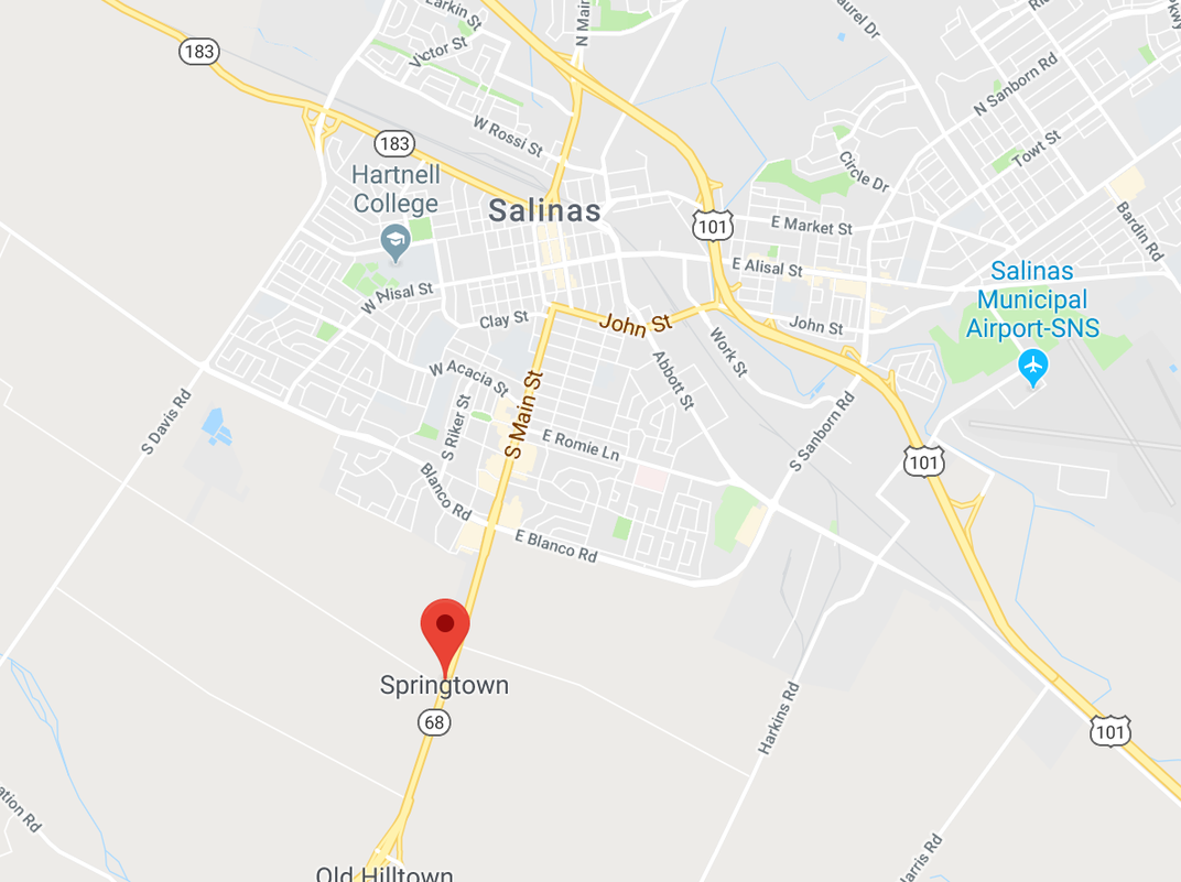
From his vantagepoint nearly 2,500 miles away, Alvero was eager to respond to the events in his own way. He turned his attention to a place closer to home: an unincorporated town just outside of Salinas named Confederate Corners.
"When I was in high school and first learned about the name, I didn't even realize that the Confederate part of 'Confederate Corners' was talking about the Confederacy," says Alvero. "But after learning that it really was, I was disgusted."
Alvero, a Ph.D student at Stanford, decided to act. He sent in an application to the U.S. Board on Geographic Names, the government entity that oversees the naming of natural features—streams, valleys, mountains, and so on—and unincorporated places such as rural towns without a large enough population to warrant a municipal governing structure. (Incorporated places, including most cities and towns, make the final decisions on the names of their own municipalities, streets, and parks.)
Alvero’s proposal noted that the name Confederate Corners was not historical, given that the region was called Springtown until a group of Confederate families moved there and changed the name in the 1860s. He proposed a new title that dovetailed more closely with the history of the town: Campesinos Corners, in reference to the Mexican-American agricultural workers who powered the region throughout the 20th century.
That application worked its way up to Jennifer Runyon, one of two full-time researchers studying domestic locations for the U.S. Board on Geographic Names based in Washington, D.C. The BGN, or “the Board” to its employees, was created in 1890 to standardize maps throughout the U.S. and sits under the Department of Interior. As settlers encroached into Native American territory in the West, they would accidentally assign different names to the same rivers or mountains (ignoring, of course, the already extant native names), and the federal government needed an organization to eliminate those discrepancies.
In the middle of the 20th century, the BGN also began reviewing petitions from individual citizens to change names that were already standardized on the U.S. map, whether because of a spelling error, a misplaced location, or something more serious—like a name that locals find offensive. Those renaming petitions first go through Runyon’s office, where she sleuths out the history behind a given name—where it comes from, who it refers to, how locals have viewed it in the past—and presents it to members of the BGN. Last year, the BGN reviewed 125 naming applications, according to the organization’s meeting minutes.
"It's one of those esoteric positions where no one really appreciates how names get on maps," says Runyon. "But somebody has to sit here and figure out what official names should be."
Runyon has spent her career bouncing between federal departments—ten years mapping farmland for the U.S. Department of Agriculture, two years analyzing nautical charts for the National Oceanic and Atmospheric Administration—before ending up in 1994 at the USGS, one of eight government entities ranging from the Postal Service to the Department of Homeland Security that send representatives to the domestic BGN. Most of the board members are chosen because they are experienced employees who are some way involved in mapping in their respective agencies—cartographers, geospatial specialists, and nautical data analysts.
The BGN sits atop a vast and at times haphazard collection of local naming authorities. Forty-nine states have at least one person whose job description includes overseeing requests for geographic name changes. The outlier, Colorado, has had no names adviser for the last two years—largely because it hasn't gotten around to appointing a person to fill the position, according to T. Wayne Furr, who heads a national organization for state names advisors.
Renaming petitions can bubble up from the county level through a vote by a local board of supervisors or be sent directly to the BGN, but petitions are often routed through the state authority so that the BGN can hear a local recommendation before it makes the final decision on name changes. "Here in D.C., we're not fully invested in what the name is," says Runyon. "We want to know what the local people think." These state decisions, however, are advisory only; only the BGN can authorize a change to a natural feature or unincorporated place on the U.S. map.
On the state level, no person in the United States works full time on names cases. Many state name boards are led by a member of the local historical society or a bureaucrat who in some way works on issues related to geography or mapping—an employee of a department of natural resources, say. When Runyon presents a renaming case to the states, she says that some take months to review the change while others respond immediately with their recommendation. She rarely gets any insights into their decision-making process.
Some states seem to take the job more seriously than others. While Oregon, Washington, Nevada, Minnesota and Alaska have regular meetings and multiple board members reviewing all names decisions, they are actually outliers, according to Runyon.
"There can be [on state boards] anywhere from 22 members to 1 person who literally inherited this job from their predecessor," says Runyon. "It just kind of fell into their lap. They don't usually know what it involves, and they usually call me. 'Hello, I'm the state names authority, what am I supposed to do?'" With people like this, Runyon guesses that they don't spend even one percent of their time on naming issues.
One of the most comprehensive systems is in Oregon. Its board is massive by state standards: a group of 25 appointed members, a haphazard mix of retired journalists, retired county officials, some lawyers, a newspaper publisher, and the former first lady of Oregon.
Kerry Tymchuk, the executive secretary for the Oregon board who is also a member of the Oregon Historical Society, says that aside from a passion for Oregon history, he has no formal restrictions on who can serve. He has appointed some people to the Oregon board simply because they wrote him a message expressing interest.
While some state names boards conduct business over email, Oregon reviews name change applications over the course of an annual weekend retreat. Last year, the board traveled to Bend, Oregon, because they were reviewing the names of a neighboring quarry—a self-funded trip—and they conducted a marathon review session in a conference room near their hotel.
The petitioners, usually around eight each year, are invited to give a short presentation on why they want the name changed. After members vote, they celebrate with a dinner paid for by the Oregon Historical Society.
Despite their prominence in the news, relatively few name change requests that come through the BGN revolve around Confederate landmarks. Oregon, for instance, has focused on renaming the multitude of geographic places that contain some variation of "squaw," a word that many Native American tribes regard as offensive. Other name change requests verge on parody, like a Nevada petition to rename a dry lake "Jackalope Bay" in honor of the mythic jackrabbit with antelope horns.
The slow drip of requests to change landmarks with Confederate names has surprised Runyon. “I confess, I thought I'd have more by now,” she says. But she suspects that the reason isn’t a lack of desire to remove these names—rather, most people either aren’t familiar with the process for requesting a name change or don't want to commit to multiple months of waiting. "A lot of people decide they don't want to go to the trouble."
Although the BGN's derogatory names policy only formally bans two words from appearing on the U.S. map—both racial slurs—Runyon says the BGN takes petitions to rename Confederate sites seriously. Each request for a name change is case-by-case, but Runyon notes that all of the BGN petitions involving a Confederate name have so far resulted in a change. But “it’s still too early to predict a trend,” she says.
“I feel a huge sense of personal responsibility in a way that I never thought was possible,” says Christine K. Johnson, a member of the Nevada State Board on Geographic Names. Johnson received the appointment after starting work as a collections manager at the Nevada Historical Society six years ago—when her coworkers found out that she holds a Ph.D in geography, they ushered her onto the Nevada board.
Johnson’s task is daunting: Because geographic names are meant to embody the identity of a place, the board's decisions have to reflect the history and culture of all of Nevada. "We're responsible, a small group of 11 people, to try and wrangle this massive landscape and understand it to the point that we can effectively represent our opinion to Washington. Even when somebody wants to name some little peak out in the middle of nowhere, we ask, what's the lasting impact?"
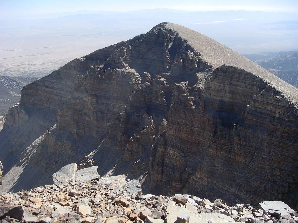
In a recent case, Johnson considered a petition to rename a mountaintop honoring the former leader of the Confederacy called Jeff Davis Peak. The name actually dated back to 1855, when Jefferson Davis served as Secretary of War prior to his attempted secession from the U.S., but given that Davis had no connection to Nevada, the choice to memorialize him felt especially odd.
When she received the application, Johnson reached out to anyone she could think of with jurisdiction over Jeff Davis Peak: the county, the local Shoshone tribe, the local forest service, and a slew of others. Although these names can have deep political impact on those who encounter them, Johnson says she attempts to evaluate each one as methodically as possible.
“Each name, it doesn't matter if you're trying to name it Donkey Peak or rename Jeff Davis Peak, each one goes through the process," she says. "If you showed up at the meeting next time, and said, ‘You know, I just really hate donkeys and I felt the need to tell you guys,’ we would take that into account.”
Not long into her research, Johnson discovered that instead of “Jeff Davis Peak,” the local Shoshone tribe had for centuries called the peak Doso Doyabi, or White Mountain—a name that she liked both because of its history and its close connection to Nevada. “I don’t view it as much as a name change than as a name restoration,” she says.
In January 2019, during one of the Nevada board's three annual meetings, representatives from eleven organizations—ranging from the Nevada Department of Transportation to the National Forest Service—went down the line and shared their concerns. The board also took time to hear from local Nevadans who had come to the meeting. Although Johnson received a handful of angry emails after the fact, none of those opposed had bothered to show up in person, and the resolution to approve the change was passed unanimously.
On June 13, 2019, six months after the state of Nevada recommended that Jefferson Davis's name be replaced, the U.S. Board on Geographic Names held its own vote.
Runyon presented opinions from a group of local constituents: letters of support for the change from the Las Vegas NAACP and a local chapter of the National Parks Conservation Association, as well opposition from two Nevada residents and—perhaps unsurprisingly—the Sons of Confederate Veterans. But in the end, the logic for keeping the name of a reviled figure who had no real connection to Nevada seemed tenuous. The BGN voted 11 to 0 to remove "Jeff Davis Peak" from the map.
When AJ Alvero's application to rename Confederate Corners reached the BGN, Runyon was tasked with reviewing it. As is her protocol, she kicked the request down to the Monterey County Board of Supervisors for feedback.
At a public meeting in December 2017, one supervisor presented a survey suggesting that 42 percent of local residents opposed any change to the name Confederate Corners. "One of the supervisors called me a kid trying to stir up trouble," says Alvero.
Although the Monterey County Board agreed to recommend a name change to the BGN, they passed on a different suggestion: Instead of Alvero's preferred name, Campesinos Corners, Monterey asked the U.S. BGN to restore the town name to "Springtown," as it was known for much of the 1800s. The BGN agreed. On April 12, 2018, nearly seven months since Alvero's initial petition, the BGN approved the change.
One month later, Alvaro logged into Google Maps. When he typed in "Confederate Corners," he was directed to the same unincorporated region he'd grown up around, except this time with a new name splayed across: Springtown.