Checking In on the Health and Vigor of the Chesapeake Bay
As clean-up milestones are registered by a recent assessment of the nation’s largest estuary, a Smithsonian geographer drops in on the region
/https://tf-cmsv2-smithsonianmag-media.s3.amazonaws.com/accounts/headshot/Doug-BPBM-2011.jpg)
/https://tf-cmsv2-smithsonianmag-media.s3.amazonaws.com/filer/9d/84/9d84ad53-b601-4f54-8c59-239419b04b73/small_boat.jpg)
It’s May, 2016, and another drizzly day on the Chesapeake. I’m aboard Hōkūle‘a, the Hawaiian voyaging canoe circumnavigating the globe promoting a message of Mālama Honua, meaning “take care of the Earth.” I joined the crew in Yorktown, Virginia, for nine days of journeying in the Chesapeake Bay area, meeting with local Indian tribes and exploring environmental issues and solutions.
For two days, the canoe has bobbed gently on the opaque, mud-colored water as we approached Tangier Island, one of the famous sinking islands of the Chesapeake. On board with us are also Kirk Havens, the assistant director of the Virginia Institute of Marine Science, his cousin Dan Havens from the Washington Canoe Club, and two gentlemen from Tangier Island: James Eskridge, aka “Mr. Mayor” and a crusty old crabber nicknamed Captain Cook, whose real name is George Cannon.
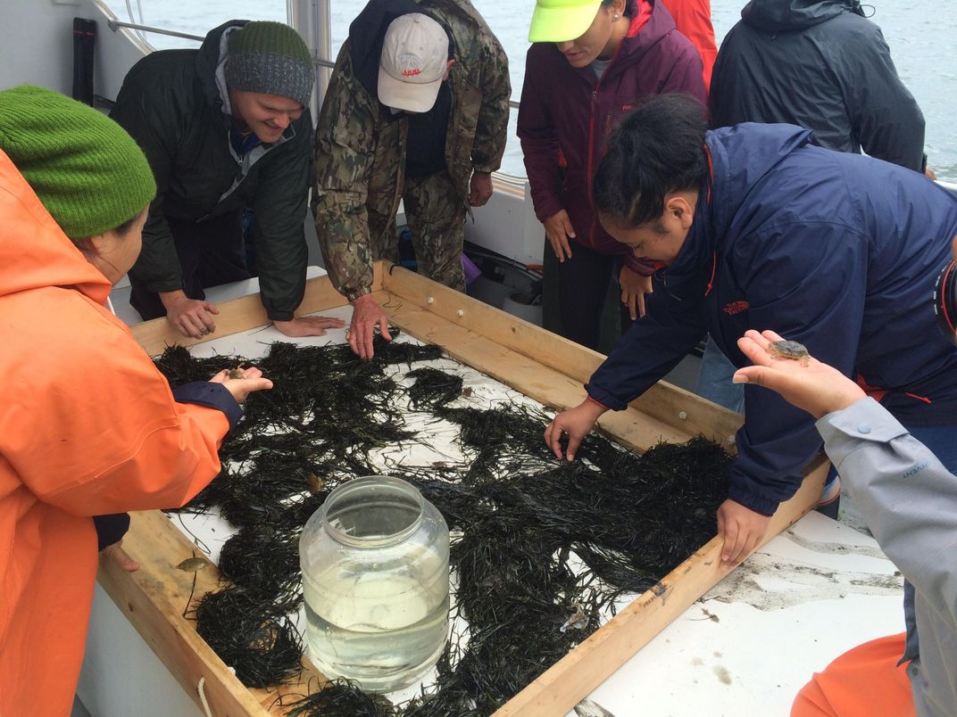
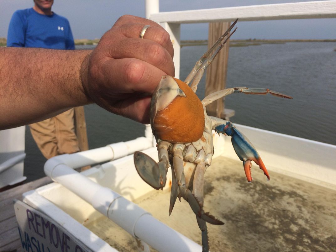
With the canoe moored at one of Tangier’s many docks, we are taken aboard an educational boat run by our hosts from the Chesapeake Bay Foundation, people devoted to preserving and educating the public about this cherished ecosystem. Captain Cook has just dropped a scraper overboard, brought up a bunch of seagrass and dumped it on a sorting table in front of us.
Because it is one of the earliest sites of continuous European settlement in the United States, and because of the importance of its ecosystem, the Chesapeake Bay is an excellent example of how modern humans have mismanaged nature’s bounty. The Bay is the largest estuary in the United States, with a 64,000-square-mile watershed feeding fresh water into this salt-water inlet, resulting in a range of aquatic and marine ecosystems.
“What makes an estuary more productive than coastal areas,” says Paul Willey, director of education operations for the Chesapeake Bay Foundation, “is the mix of fresh and salt waters. But what makes the Chesapeake Bay even more productive is that it’s shallow.” Average depth in the main portion is only about 30 feet, decreasing to 20 feet if you include the tidewater tributaries. “It’s just mind-boggling to think of how productive this bay was, even 150 years ago,” Paul adds.
Fortunately efforts to improve the health of the bay have increased in the past few decades, as the extent of its condition affected more and more industries. But as the country’s largest estuary, the watershed—not to mention the airshed—the Chesapeake Bay is enormous, encompassing several different states and state governments. When efforts began in the 1980s, each jurisdiction made its own rules independently, and they were all voluntary. In 1998, the Chesapeake Bay Foundation (CBF) published the first “State of the Bay,” a report card on the Bay’s health. They graded it a 27 on a scale of 100. Lawsuits have been filed against the Environmental Protection Agency (EPA) for not using its authority to set pollution limits. In 2010, the EPA and its partners developed “the landmark Chesapeake Bay Total Maximum Daily Load (TMDL), setting limits on the amount of nitrogen, phosphorus and sediment that can enter the Bay and its tidal rivers to meet water quality goals.” The 2010-2025 Chesapeake Clean Water Blueprint for action was set in place.
In 2018, the CBF published its Midpoint assessment report. The report tracks the extent to which the six states, plus the District of Columbia, in the Bay’s watershed have met their goals of reducing the amounts of nitrogen, phosphorus and sediment entering the bay from agriculture, urban and suburban polluted runoff, and wastewater and sewer outflow. Most states exceeded their wastewater goals and some met their goals for agriculture, but others have not, and polluted runoff remains a critical issue. Climate change and air pollution threaten the progress being made.
When Captain John Smith sailed this bay 400 years ago, the water clarity in the bay was exceptional, thanks to the natural filtration provided by oysters, wetlands and submerged grass beds. Smith wrote that oysters “lay as thick as stones,” and the fish population included “sturgeon, grampus, porpoise, seals, stingrays . . . brits, mullets, white salmon [rockfish], trout, soles, perch of three sorts” and a variety of shellfish. The schools of fish could be so massive that at one point Smith and his men attempted to catch them with frying pans.
This was an ecosystem lightly trammeled by the native peoples who lived in dispersed and shifting settlements throughout the region. They drew on the bounty of the bay itself, as well as the abundant game on land and in the air, plus a variety of farming practices.
Europeans colonists arrived with the intent to acquire land, and to produce wealth, within the context of the emerging global economy, using the available environmental resources—fish, minerals, agricultural land and forests.
They cleared forests, plowed fields and spread fertilizer, which interfered with streams and waterways. From the reduced forest cover, sediment and fertilizer flowed into the streams—overwhelming underwater grasses that cleansed the water, and increasing nutrients that spawned the growth of microscopic algaes and planktons. This is true of estuaries worldwide, and as Robert Carter of the Virginia Department of Historic Resources writes: “The decline of estuaries, without a doubt among the planet’s most important nursery grounds, represents one of humanity’s greatest challenges and most obvious management failures.”
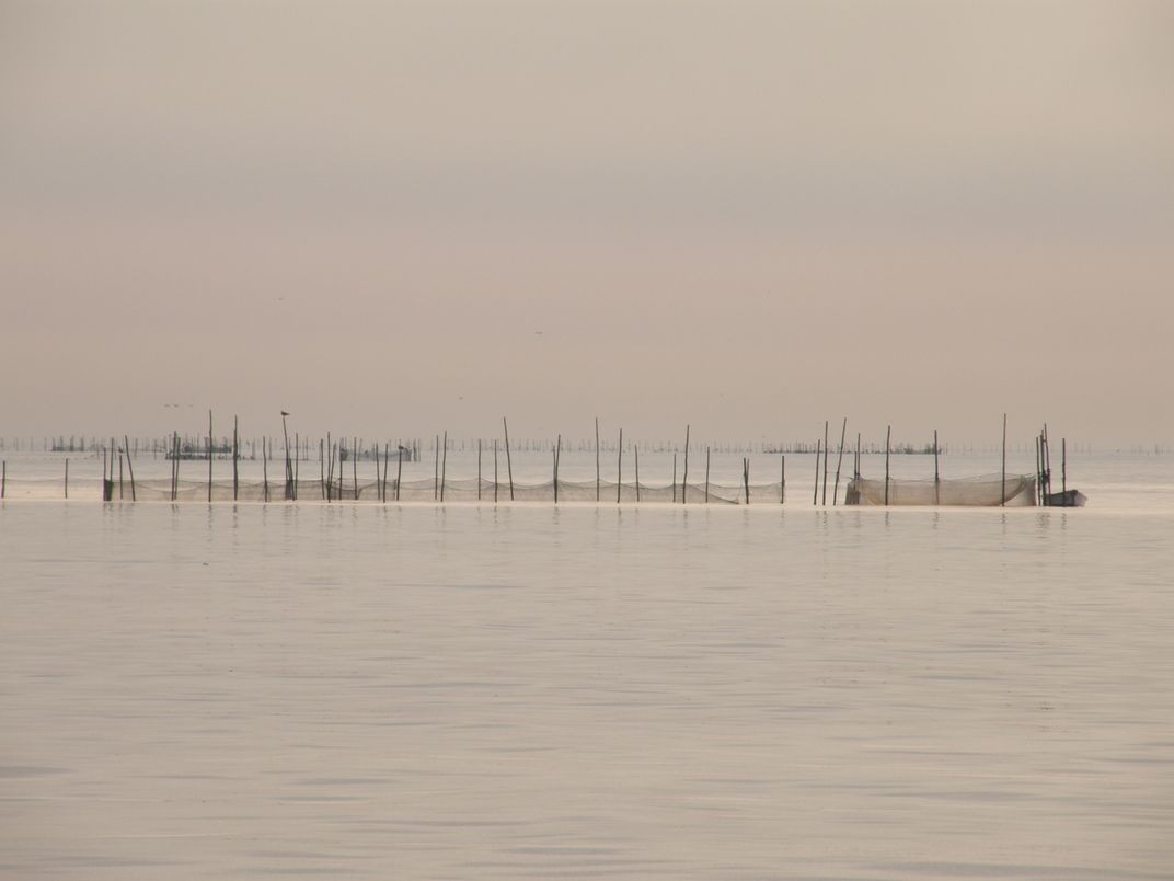
The waters of the bay seems always to be brown with sediment, especially after a rain. As we made our way towards Tangier Island, we saw numerous fish wiers. These are sticks driven into the shallow bottom, holding nets in a funnel shape that guides fish into heart-shaped net pockets. The same technology was used by Indians, who began teaching the Europeans how to do it as early as 1608.
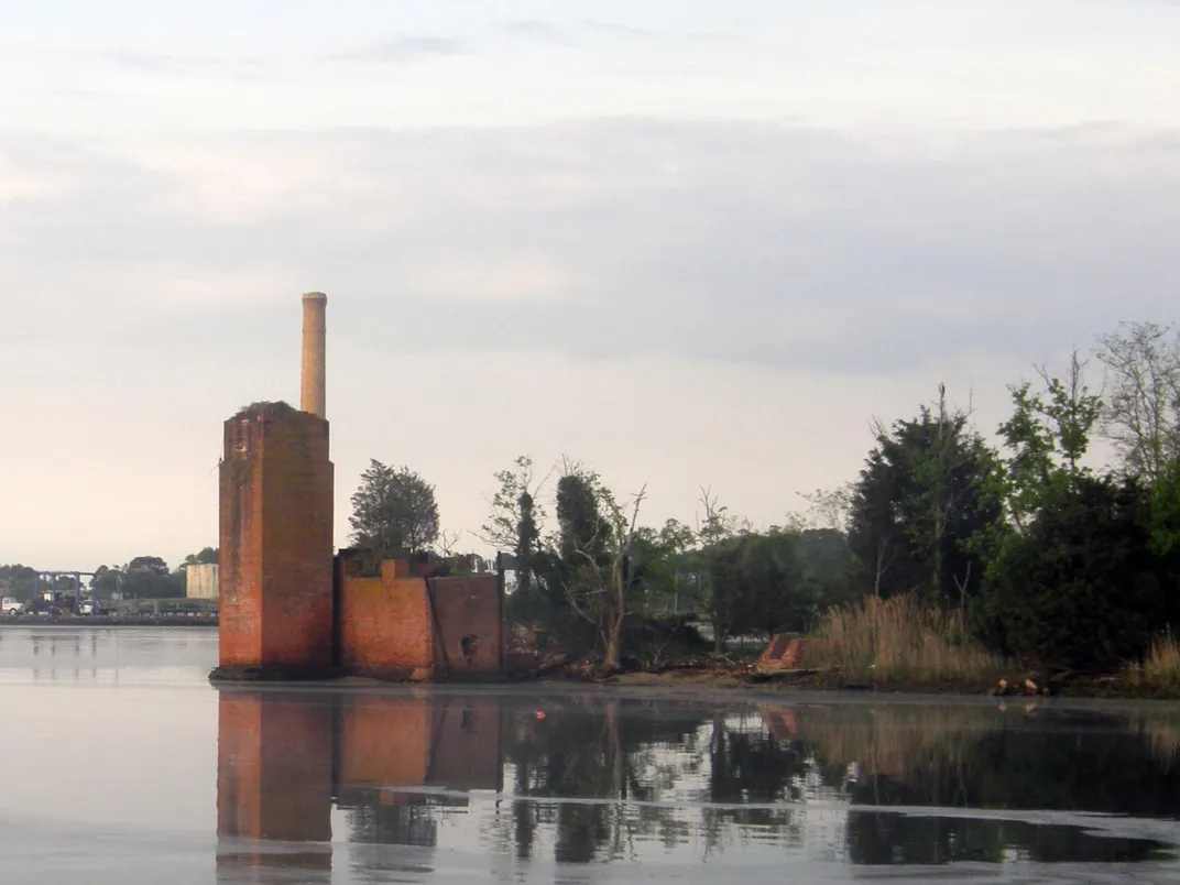
We didn’t reach Tangier Island that first night, but pulled in at Reedville. Here a Maine sea captain named Elijah Reed had set up shop to fish the vast school of menhaden. A member of the herring family, menhaden are filter-feeders that thrive on zooplankton and phytoplankton, thereby providing a key role in the Chesapeake ecosystem. They are an oily fish, not generally eaten by humans, but processed into fish meal, fish oil and fertilizer. Their incredible abundance in the mid 19th-century turned Reedville into one of the world’s leading fishing ports, with a per capita income that was among the highest in the United States.
Reedville looks like an odd mix of ghost town, fishing town and suburb. The menhaden were declared overfished in 2012. Factories have come and gone, leaving old warehouses and crumbling remnants of towers where ospreys make their nests. But sprawling old homes speak to the former wealth of the town, and fishing ships are still present. Reedville is also one of the few places where one can catch a ferry to Tangier Island.
In the gray haze with rain threatening, we set out for Tangier. “Where are you from?” Mayor James Eskridge asked me. I told him I was born and raised in Washington, D.C. but that I now live in Baltimore. “Then I guess you must be used to being around a whole lot of people.”
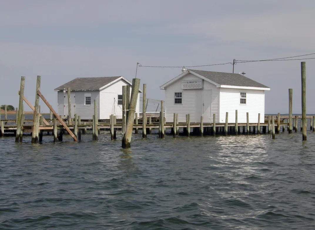
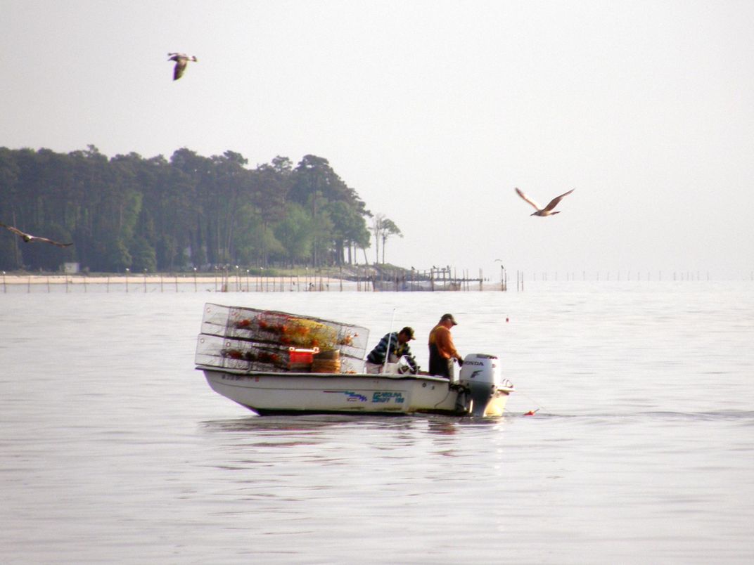
Tangier is one of a small group of islands forming a remote outpost in the Chesapeake Bay. Captain John Smith came across it in 1608. The island has had a colorful history since then, including a distinct dialect of Tidewater English closer to its British roots than to mainstream U.S. English. Much has been written recently about Tangier because of the conflicts over the crabbing industry—the mainstay of the island—and because the island, like the land all around and in the bay, is sinking due to tectonic forces and losing ground as climate change-induced sea levels rise.
We entered a seaside the likes of which I had never seen before: little houses perched on piers stretch out in the water and all around us. We pulled up to the dock in the rain, set up a tarpaulin over the deck, and welcomed the scores of school children that had come to see Hōkūleʻa. Later that evening, after dinner and ceremony, a group of local kids were seated in a circle, along with Hōkūle‘a’s master navigator Nainoa Thompson, the current navigator Chad "Kkelepa" Baybayan and some of the senior people from the canoe.
The older voyagers spoke of the bay, of Mālama Honua, and of what voyaging has to teach about life on small islands. The young people asked questions, and spoke of their own concerns for the future. One senior member quoted the lessons of the late master navigator Mau Piailug, who said that a seafarer must “see the island”—the destination—in his or her mind when one starts out on a voyage. He told them “you’re already on the canoe, and the future is a distant island. The question is, what kind of future do you want to see? Envision that ‘island,’ and raise it from the sea.”
We stayed in dormitories of the Chesapeake Bay Foundation on neighboring Point Isabel, and the next day were out on the Foundation’s educational boat with Captain Cook to scrape the sea bed. Once the scrapings had been dumped on a table, we were told to set about sorting through the grass to see what we could find. The question posed to us was: “How does the health of the Bay seem, based on what you see here?”
Little baby crabs went skittering all over the place. Pipefish—a relative of the seahorse—wriggled about and were dumped into a large, clear jug of bay water, along with small shrimp and curious bug-like creatures. We said that it looked more or less like abundance, and they agreed that what we saw looked healthy—healthier, they told us, than it had been not long ago, thanks to concerted efforts to clean up the bay.
Our guides from the Chesapeake Bay Foundation explained the importance of the sea grass and the health of the bay, and how the teaming life on the table in front of us reflected a healthy area, thanks to efforts to reduce the pollutants. “We’re at the southern limit of eelgrass,” Paul Willey explained. “Eelgrass is a productive habitat and nursery area for a lot of smaller species.” Kirk Havens added, “Decrease the water clarity and we lose the eelgrass. Bigger species, such as water fowl, feed on the smaller species, so there’s a feedback loop.”
Water clarity was brought home to us at our next stop, a subsidiary campus of Longwood University on the Northern Neck of Virginia. Two aquarium tanks had been filled with cloudy water from the inlet that morning. In one tank, there was nothing but water. In the other tank, there were live oysters. Near the end of the day, the difference between the two tanks was stark. The first one was still cloudy, while the second one had become clear, thanks to the filter-feeding oysters.
Oysters provide key benefits to the bay. They build reefs—massive structures that help stabilize sediment flow. These reefs of alkaline shells provide a chemical buffer against the acidic freshwater that enters the bay from its tributaries, thereby enabling the survival of many marine invertebrates that in larval form need the right pH to survive. And oysters feed on the phytoplankton and zooplankton, cleaning the waters. In fact, biologists have recently estimated that when Captain John Smith sailed here, oysters were so plentiful that they filtered the entire bay once a week. Add to that the massive schools of filter-feeding menhaden and you have pristine waters, clear down to 20 feet or more.
The Indians of the Chesapeake ate oysters, but their technology—and perhaps their sense of balance with nature—limited their ability to harvest them beyond the shallower waters. Early colonists followed suit. But in the 1830s and '40s, the discovery of deeper oyster reefs coupled with the advent of new technologies to harvest, can and transport oysters turned the Chesapeake Bay into “a maritime version of the Wild West.” This history is recounted by Dr. Henry M. Miller of Historic St. Mary’s City, and powerfully displayed at the Chesapeake Bay Maritime Museum in St. Michaels, Maryland. In the 1880s, the harvest would reach 20 million bushels.
But sadly, the oysters were over-exploited to the point of depletion, the ecosystem was altered and weakened, and then (in this case) some introduced diseases further devastated them. As Miller states, “Today, virtually nothing is left of the abundant oyster bars and reefs of the past. Efforts to restore the native oysters are meeting with success, and there is a goal to have ten Chesapeake Bay tributaries restored by 2025.
At our departure, the Longwood University folks gave us each a fossil shark tooth, which had eroded out of a cliff further up the Potomac. A reminder of how the Earth changes over time, even without human interference and a Mālama Honua lesson on how careful we have to be to maintain the bounteous balance that we have, while we can.
/https://tf-cmsv2-smithsonianmag-media.s3.amazonaws.com/accounts/headshot/Doug-BPBM-2011.jpg)