The Great Midwest Earthquake of 1811
Two hundred years ago, a series of powerful temblors devastated what is now Missouri. Could it happen again?
/https://tf-cmsv2-smithsonianmag-media.s3.amazonaws.com/filer/Phenomena-earthquake-central-631.jpg)
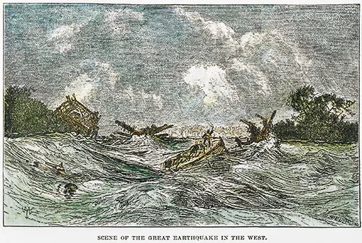
At 2:15 a.m. on December 16, 1811, residents of the frontier town of New Madrid, in what is now Missouri, were jolted from their beds by a violent earthquake. The ground heaved and pitched, hurling furniture, snapping trees and destroying barns and homesteads. The shaking rang church bells in Charleston, South Carolina, and toppled chimneys as far as Cincinnati, Ohio.
“The screams of the affrighted inhabitants running to and fro, not knowing where to go, or what to do—the cries of the fowls and beasts of every species—the cracking of trees falling...formed a scene truly horrible,” wrote one resident.
As people were starting to rebuild that winter, two more major quakes struck, on January 23 and February 7. Each New Madrid earthquake had a magnitude of 7.5 or greater, making them three of the most powerful in the continental United States and shaking an area ten times larger than that affected by the magnitude 7.8 San Francisco earthquake of 1906.
The Midwest was sparsely populated, and deaths were few. But 8-year-old Godfrey Lesieur saw the ground “rolling in waves.” Michael Braunm observed the river suddenly rise up “like a great loaf of bread to the height of many feet.” Sections of riverbed below the Mississippi rose so high that part of the river ran backward. Thousands of fissures ripped open fields, and geysers burst from the earth, spewing sand, water, mud and coal high into the air.
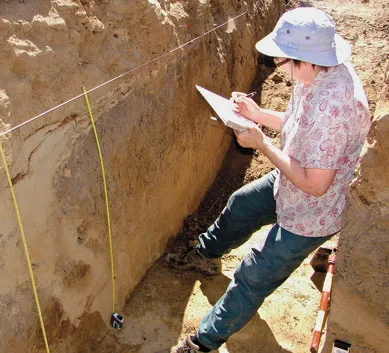
Geologists once assumed that the 1811-12 disaster was a one-time event and little cause for concern for the people who now live near the epicenter. Then, two decades ago, paleoseismology expert Martitia Tuttle and her colleagues began dissecting “sand blows” in the five states surrounding New Madrid. The sand blows were left by geysers when debris surged up through narrow dikes and landed in wide mounds. “Sand blows tell a dramatic story of the widespread shaking of these large earthquakes,” she says.
Tuttle’s team excavated potsherds, spear points and corn kernels and realized that many of the sand blows were more than 200 years old. “Some had archaeological sites on top of them with 2,000-year-old artifacts,” Tuttle says. “There’s no way the New Madrid earthquakes were a one-time freak event.” The Midwest had been slammed by violent quakes around A.D. 1450 and 900 and 2350 B.C.—and probably more often.
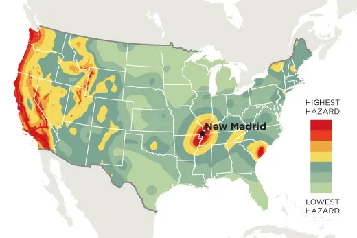
Most earthquakes occur at the edges of the earth’s 15 major tectonic plates; when they slide against each other, the ground gets a jolt. But New Madrid sits in the middle of a plate. Its seismic history—and the magnitude 5.8 Virginia quake that shook the East Coast earlier this year—is a reminder that earthquakes can strike in surprising places.
Plate interiors are riddled with ancient faults. Beatrice Magnani wants to find out why some, like New Madrid’s, are still seismically active. Early one morning, Magnani, a seismologist at the University of Memphis, guided a steel cylindrical air gun from a tugboat into the silty waters of the Mississippi River and then tested it. Boom! Everyone onboard felt, more than heard, the shot. Muddy water rippled, and a bubble bigger than a coffee table rose to the surface. Sound waves from the air gun traveled to the bottom of the river, then through the sludge and sediment to bedrock and a mile deep into the earth’s crust.
Magnani’s team dropped a large buoy off the tug with a splash. The buoy drifted downriver, dragging a 300-foot-long, two-inch-wide tube strung with microphones. A crane lifted what looked like a large yellow manta ray, an instrument called a Chirp, and lowered it into the water.
The Chirp started pinging, five times every second. The air gun blasted every seven seconds. When data from the microphones reached the computers onboard, they beeped. Ping, ping, ping, ping, Boom!, beep. The racket would continue for eight hours as the boat floated ten miles downriver.
Over the past three years, Magnani has used these tools to map the ground below the river in the New Madrid Seismic Zone, a fault system stretching about 150 miles from Cairo, Illinois, to Marked Tree, Arkansas. It’s the most active seismic area in the United States east of the Rockies, with about 200 small quakes a year.
Magnani’s most startling discovery came south of the seismic zone: two faults, one near Memphis, both active in the past 10,000 years. Other researchers have recently identified faults near Commerce, Missouri, and other places outside the New Madrid Seismic Zone that have been active in the past few thousand to millions of years, suggesting that the middle of the country is less stable than it seems.
Geologists have long blamed the New Madrid earthquakes on the Reelfoot Rift, a 500-million-year-old area of weakness in the crust. But the newfound faults lie outside the rift. “Maybe the reason we haven’t been able to solve the mystery of the New Madrid earthquakes is that we’ve been too focused on New Madrid,” Magnani says. “Maybe earthquake activity moves around systematically over time.”
Tuttle has begun a four-year project to date sand blows inside and outside the New Madrid Seismic Zone. “We’ve got to get a solid understanding of what large earthquakes happened where and when,” she says. That’s the best way to estimate the hazard to the Midwest and its millions of people and countless highways, bridges, skyscrapers and crumble-prone brick buildings.
The U.S. Geological Survey estimates that the risk of another New Madrid-scale catastrophe in the next 50 years is about 7 to 10 percent. The risk of a smaller, though still devastating, 6.0 earthquake in the next 50 years is 25 to 40 percent. Ongoing research should help identify which areas are most in danger.
“We need a broader, yet clearer picture of all the networks of faults that have been active in the region,” says Magnani. “We need to find out how big they are and their underlying structures. That’s the only way we can hope to understand intraplate earthquakes—and ultimately keep people safe.”
Elizabeth Rusch wrote about extracting energy from ocean waves for Smithsonian.