New Tracking Technology Reveals Hidden Animal Migration Routes
Using improved GPS collars, scientists are mapping more herd migration routes than ever before, a key to conservation efforts in the western United States
/https://tf-cmsv2-smithsonianmag-media.s3.amazonaws.com/accounts/headshot/Kristen_A._Schmitt.jpg)
:focal(749x457:750x458)/https://tf-cmsv2-smithsonianmag-media.s3.amazonaws.com/filer/ce/2a/ce2a1e6d-c812-4606-b8ea-eb10141138ae/dsc_193422.jpg)
As the cold sets in, and snow turns the western mountain ranges of the United States into winter’s playground, thousands of deer, elk, moose, bighorn sheep, bison and mountain goats begin their seasonal trek to lower elevations. The herd mammals follow historic routes, passed along by mother to young from year to year until they are instinctually ingrained in the animals. Some of the routes can take decades to become second nature.
These wildlife migration routes make up a series of distinct pathways that animals follow to survive in highly seasonal climates, like the mountains of Wyoming, says Matthew Kauffman, a professor of zoology and physiology at the University of Wyoming and director of the Wyoming Migration Initiative.
“It takes generations and generations for herds to learn migration corridors,” Kauffman says. “If you wipe out a herd that has knowledge of a specific migration, then you lose all the knowledge that those animals have of how to make that migration.”

Wild Migrations: Atlas of Wyoming's Ungulates
Kauffman recently served as senior editor of the newly-released book, “Wild Migrations, Atlas of Wyoming’s Ungulates.” His team collaborated with fellow scientists, cartographers, historians, wildlife specialists and photographers to produce a comprehensive analysis of Wyoming’s ungulate migration patterns. Decades of data collected through satellite tracking collars were studied to identify migratory patterns of big game animals native to Wyoming, and the work could provide a broad roadmap for future conservation projects focusing on many different species.
“There are some similar things for bird migration,” Kauffman says, “but for big game migration—for ungulates specifically—this is the first one of its kind. We’ve taken fairly cutting-edge scientific studies and tried to distill them down for the atlas.”
Mapping New Migration Routes
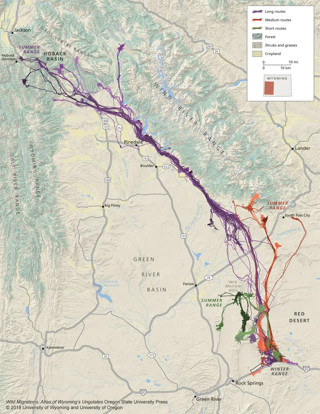
Earlier this year, Doe number 255 (named by her GPS collar) began her spring migration across much of Wyoming, traveling the herd's familiar route from the Red Desert to Hoback—a trek identified in 2012 as one of the longest mule deer migration routes at 150 miles long. But 225 didn’t stop when the rest of the herd did. Instead, she continued travelling until she reached Island Park, Idaho, and her GPS collar died, leaving the rest of her journey—and her current whereabouts—unknown.
“My colleague, Hall Sawyer, discovered the Red Desert to Hobart migration corridor,” Kauffman says. “If you think about moving 150 miles anywhere in the U.S., you run into a bunch of obstacles. The herd crosses lands that are managed by state agencies and federal agencies, 41 different private property owners, close to 100 fences [and] three to four different highways.”
One lone mule deer’s decision to continue down a separate path and travel an additional 90 miles shows how little is really known about wildlife migration. The patterns are always changing, routes go in and out of favor, and sometimes, individual animals decide to leave the herd behind.
/https://tf-cmsv2-smithsonianmag-media.s3.amazonaws.com/filer/56/bb/56bbee09-4f54-4388-893c-47e6bdc278e9/_dsc6027-cv2.jpg)
“That route must be rare within the herd because we hadn’t detected it prior to that,” Kauffman says. He acknowledges that identifying migration routes depends on the high fidelity within a herd, or the tendency for animals to return to the same habitats every year. Each species has unique pathways and timing, but the majority travel to the same summer ranges and return to the same winter ranges, year after year. “Because the animals are really consistent in using those routes, it makes it easier to map a specific route and identify it as a key migration corridor,” Kauffman says.
In Pinedale, Wyoming, for example, this data helped keep a critical bottleneck that 4,000 to 5,000 pronghorn use to migrate undeveloped. Nestled between 12,000- to 14,000-foot peaks along the shores of a deep glacial lake lies the small town of Pinedale. A 360-acre parcel of private land there nearly sold for the development of lakeside cottages.
“Had it been sold and developed, it would have literally just plugged up that migration,” Kauffman says.
Fortunately, using tracking collars, the team was able to identify this critical route, and a conservation fund raised the money necessary to purchase the property and turn it over to the state as a wildlife habitat management area. Fences were taken down and the actual bottleneck was improved, and Pinedale now supports the nation’s first federally protected wildlife corridor.
“We have the technology to map these corridors,” Kauffman says. “The herds willingly show you once you capture and collar them, and as more and more migration corridors are mapped, people can use those maps to evaluate where the risks and threats are and figure out ways to solve those to keep those areas open.”
How GPS Tracking Collars Work
“The first GPS collars were created in the early to mid-1990s,” says Stan Tomkiewicz, Director of Environmental Programs at Telonics, which supplies tracking collars and other wildlife technology for use in scientific, military, and search and rescue applications. “And it wasn’t really designed so much for tracking as a system. It was designed to pinpoint locations.”
Prior to the invention of GPS tracking collars, scientists relied primarily on fieldwork (animal observations, tracks, trails, scat) to hypothesize where and when animals migrated during their yearly pilgrimages. Recent advancements in GPS satellite technology have made it possible to not only locate animals with a high degree of accuracy, but to do so every hour if desired.
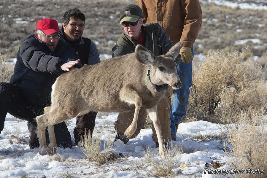
Generally, once a GPS collar is attached to an animal through a capture and collaring mission, there are two ways the collar can track location data. The collars can monitor position via direct satellite feed that delivers information in real time to scientists, or they can store data on an internal computer chip similar to what’s found in an iPhone. In the latter case, the collar is programmed to release, dropping off the animal’s neck, at a predetermined date. Researchers then collect the dropped collars to access the data.
“Collars are becoming incredibly sophisticated,” Tomkiewicz says. “We can actually talk directly to the collars when they are on the animals and can reprogram them to do different things.”
For example, researchers can set up “geofences,” which send out a notification once a herd or group of animals leaves the predetermined digital borders. Once the migration begins, other tweaks to the collars can be made without disturbing the animals.
“Let’s say you’re interested in migration and it starts up,” Tomkiewicz says. “Well, we can intensify the scheduling of GPS positioning texting, so you can get data more frequently during the migration.”
While transmitting data in real time is appealing, satellite collars cost about $3,000 each, whereas store-on-board collars, which detach from the animals at a predetermined time, cost about $1,200, according to Wild Migrations, Atlas of Wyoming’s Ungulates. With six to eight herd studies going on at a time—and 20 to 100 animals within each herd collared—tracking can become quite expensive. However, identifying key migration routes helps scientists understand current habitat needs and determine which areas require efforts to maintain these routes for future generations.
The Future of Conservation
In February, former U.S. Secretary of the Interior Ryan Zinke signed Secretarial Order 3362, which outlines habitat improvement projects for western big game winter range and migration corridors used by antelope, elk and mule deer. The order specifically targets migration corridors in Arizona, California, Colorado, Idaho, Montana, Nevada, New Mexico, Oregon, Utah, Washington and Wyoming. Pushing for collaboration between state and federal agencies to improve these areas is a first step toward sustaining the critical routes that animals rely on.
“We have had a lot of energy development coming into the state for the last two decades,” Kauffman says. “Because of this, there's been a really strong focus on mapping the migrations and then looking at threats to identify conservation opportunities.”
Kauffman hopes that by mapping Wyoming’s migration corridors, other western states will see the value of identifying these routes for conservation and habitat improvement projects, like removing unnecessary livestock fencing to limit entanglement, establishing designated wilderness areas where development cannot occur, limiting oil and gas development that would disrupt instinctive routes, supporting land easements similar to the Pinedale bottleneck effort, and working with state transportation departments to create safer crossings over busy highways and decrease the number of wildlife-vehicle collisions.
It appears that other states are indeed following Wyoming’s lead. Utah recently received federal funding to improve mule deer migration corridors. Colorado is studying Gunnison Basin elk movements. Oregon is improving wildlife corridors along U.S. Highways 97 and 20. New Mexico is in the middle of a multi-year study aimed at understanding how oil and gas development impacts mule deer populations.
While most of these projects “build off of some of the things that have been happening in Wyoming for the last decade,” Kauffman is pleased at the progress and optimistic that current projects—and future ones—will be used “to keep these corridors open and sustain them.”
A Note to our Readers
Smithsonian magazine participates in affiliate link advertising programs. If you purchase an item through these links, we receive a commission.
/https://tf-cmsv2-smithsonianmag-media.s3.amazonaws.com/accounts/headshot/Kristen_A._Schmitt.jpg)