Landslide “Quakes” Give Clues to the Location and Size of Debris Flows
Scientists can now quickly assess characteristics of a landslide soon after slopes fail, based on its seismic signature
/https://tf-cmsv2-smithsonianmag-media.s3.amazonaws.com/accounts/headshot/mohi-kumar-240.jpg)
/https://tf-cmsv2-smithsonianmag-media.s3.amazonaws.com/filer/20130327123216Southern_Leyte_mudslide_2006-small.jpg)
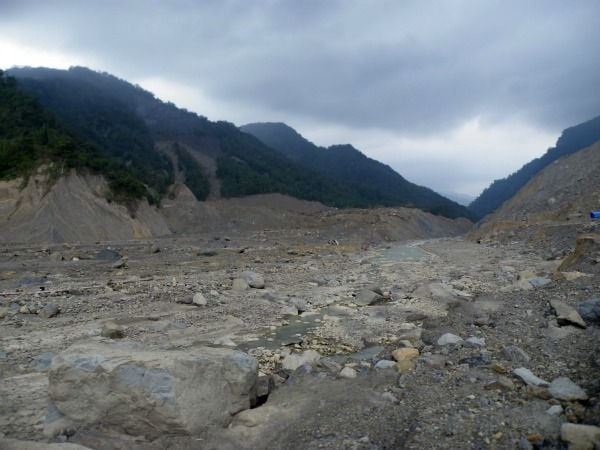
Imagine a 100-million-ton mass of rock, soil, mud and trees sliding off a mountain 30 miles from a major city, and no one knowing that it happened until days later.
Such was the case after Typhoon Morakot hit Taiwan in 2009, dumping around 100 inches of rain in the southern regions of the island over the course of 24 hours. Known as the Xiaolin landslide, named for the village it hit and obliterated, the thick carpet of debris it left behind smothered 400 people and clogged a nearby river. Though only an hour’s drive outside of the crowded city of Tainan, officials didn’t know about the landslide for two days.
“To be that close and not know that something catastrophic had happened is just amazing,” notes Colin Stark, a geomorphologist at the Lamont-Doherty Earth Observatory (LDEO). But now, “seismology allows us to report on such events in real time.” Research published last week in Science by Stark and lead author Göran Ekström, an LDEO seismologist, show that scientists armed with data from the Global Seismographic Network can not only pinpoint where a large landslide occurred, but also can reveal how fast the churning mass traveled, how long it ran out, its orientation within the landscape and how much material moved.
All this can be done remotely, without visiting the landslide. Moreover, it can be done quickly, in stark contrast to the more tedious methods typically used to estimate characteristics of a landslide. In the past, scientists had to wait for reports of a landslide to filter back to them, and once alerted they searched for photos and satellite images of the slide. If they could, they coordinated trips to the landslide tongue—well after the event—to estimate the mass of disturbed rock.
But the new method puts landslide detection and characterization in line with how scientists currently track earthquakes from afar. Just as seismometers tremble when energy from a strong quake hits their locations, allowing seismologists to determine the precise location, depth and direction of rupture as well as the amount of energy released during the quake and the type of fault tectonic plates slid along, these same seismometers move during a landslide. The shaking isn’t the frenetic twitches typically seen in seismographs of earthquakes or explosions—the signatures are long and sinuous.
Ekström and colleagues have spent many years combing through reams of seismic data in search of unusual signatures that can’t be traced to typical earthquakes. Previously, their work on seismic signatures in tectonically dead Greenland classified a new type of shaking, called “glacial earthquakes.” But the genesis of the recent research on landslides can be traced back to Typhoon Morakot.
After the storm hit Taiwan, Ekström noticed something strange on global seismic charts—their wiggles indicated that a cluster of events, each with shaking exceeding a magnitude 5 earthquake, had occurred somewhere on the island. “Initially, no other agency had detected or located the four events that we had found, so it seemed very likely that we had detected something special,” Ekström explained. A few days later, news reports of landslides—including the monster that swept through Xiaolin—began to pour in, confirming what the scientists hypothesized about the events’ source.
Equipped with seismic data from the Xiaolin landslide, the authors developed a computer algorithm to search for telltale seismic signatures of large landslides in past records and as they happened. After collecting information from the 29 largest landslides that occurred around the world between 1980 and 2012, Ekström and Stark began to deconstruct seismic wave energies and amplitudes to learn more about each.
The guiding principles behind their method can be traced to Newton’s third law of motion: for every action, there is an equal and opposite reaction. “For instance, when rock falls off a mountainside, the peak is suddenly lighter,” explains Sid Perkins of ScienceNOW. The mountain “springs upward and away from the falling rock, generating initial ground motions that reveal the size of the landslide as well as its direction of travel.”
Looking across all their analyses, Ekström and Stark find that, regardless of whether the landslide was triggered by an erupting volcano or a scarp saturated with rainwater, landslide characteristics are governed by the length of the mountainside that broke off to start the landslide. This consistency hints at hitherto elusive broad principles that guide landslide behavior, which will help scientists to better assess future hazards and risk from failing slopes.
For those who study landslides, the paper is seminal for another reason. David Petley, a professor at the U.K.’s Durham University, writes in his blog that “we now have a technique that allows large landslides to be automatically detected. Given that these tend to occur in very remote areas, they often go unreported.”
Petley, who studies landslide dynamics, wrote a companion piece to Ekström’s and Stark’s paper, also published in Science, that provides a bit of perspective to the new results. He notes that “the technique currently overdetects large, fast landslides by an order of magnitude, requiring considerable work, for example, with satellite imagery to filter out the false-positive events. Nevertheless, it opens the way to a true global catalog of rock avalanches that will advance understanding of the dynamics of high mountain areas. It may also enable the real-time detection of large, valley-blocking landslides, providing a warning system for vulnerable communities downstream.”
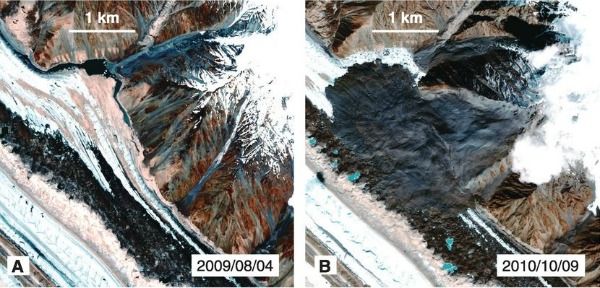
The insight gained by Ekström’s and Stark’s method is readily seen in a striking example of a landslide that occurred in northern Pakistan in 2010. Satellite images of debris flow, which is spread on the flanks of the Siachen Glacier, suggest that the event was triggered by one, maybe two episodes of slope failure. However, Ekström and Stark show that the debris slid from seven large landslides over the course of a few days.
“People rarely see large landslides happen; they typically only see the aftereffects,” Ekström notes. But thanks to him and his co-author, scientists around the world can now quickly get a first glance.
/https://tf-cmsv2-smithsonianmag-media.s3.amazonaws.com/accounts/headshot/mohi-kumar-240.jpg)