/https://tf-cmsv2-smithsonianmag-media.s3.amazonaws.com/filer/3b/f1/3bf1b848-e1fb-4bcd-a7c0-b17a9323e66f/quadraisland_mobile.jpg)
/https://tf-cmsv2-smithsonianmag-media.s3.amazonaws.com/filer/62/d4/62d44cee-0366-4a43-b6d5-74e1ad5dea6c/quadraisland_lfo.jpg)
For more than half a century, the prevailing story of how the first humans came to the Americas went like this: Some 13,000 years ago, small bands of Stone Age hunters walked across a land bridge between eastern Siberia and western Alaska, eventually making their way down an ice-free inland corridor into the heart of North America. Chasing steppe bison, woolly mammoths and other large mammals, these ancestors of today’s Native Americans established a thriving culture that eventually spread across two continents to the tip of South America.
In recent years, however, that version of events has taken a beating, not least because of the discovery of archaeological sites in North and South America showing that humans had been on the continent 1,000 or even 2,000 years before the supposed first migration. A subsequent theory, known as the “Kelp Highway,” came closer to the mark: As the massive ice sheets covering western North America retreated, the first humans arrived on the continent not only by foot but by boat, traveling down the Pacific shore and subsisting on abundant coastal resources. Supporting that idea are archaeological sites along the West Coast of North America that date back 14,000 to 15,000 years.
Now our understanding of when people reached the Americas—and where they came from—is expanding dramatically. The emerging picture suggests that humans may have arrived in North America at least 20,000 years ago—some 5,000 years earlier than has been commonly believed. And new research raises the possibility of an intermediate settlement of hundreds or thousands of people who spread out over the wild lands stretching between North America and Asia.
The heart of that territory has long since been submerged by the Pacific Ocean, forming the present-day Bering Strait. But some 25,000 to 15,000 years ago, the strait itself and a continent-size expanse flanking it were high and dry. That vanished world is called Beringia, and the developing theory about its pivotal role in the populating of North America is known as the Beringian Standstill hypothesis—“standstill” because generations of people migrating from the East might have settled there before moving on to North America.
Much of this new theorizing is driven not by archaeologists wielding shovels but by evolutionary geneticists taking DNA samples from some of the oldest human remains in the Americas, and from even older ones in Asia. Those discoveries have opened a wide gap between what the genetics seem to be saying and what the archaeology actually shows. Humans may have been on both sides of the Bering Land Bridge some 20,000 years ago. But skeptical archaeologists say they will not believe in this grand idea until they hold the relevant artifacts in their hands, pointing out that no confirmed North American archaeological sites older than 15,000 to 16,000 years currently exist. But other archaeologists are confident it is only a matter of time until older sites are discovered in the sprawling, sparsely populated lands of eastern Siberia, Alaska and northwestern Canada.
It’s an exciting, if at times esoteric, debate, touching on basic questions we’re all connected to, such as why people first came to the Americas and how they managed to survive. Yet no matter when or how they made the trek, the coast of what is now Canada was on their itinerary. And that’s what brought me to British Columbia to meet up with a group of anthropologists who have discovered important signs of ancient life along the Pacific.
* * *
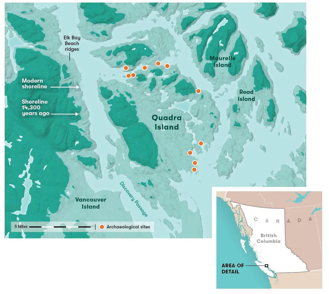
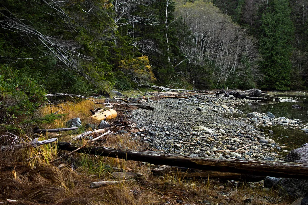
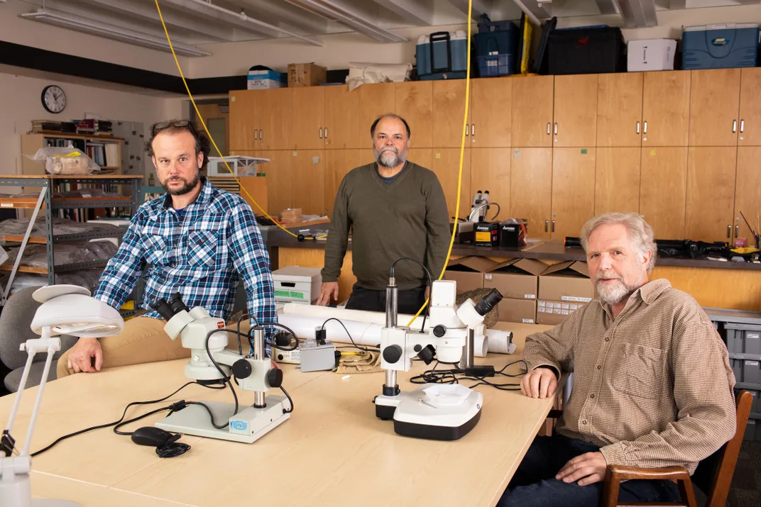
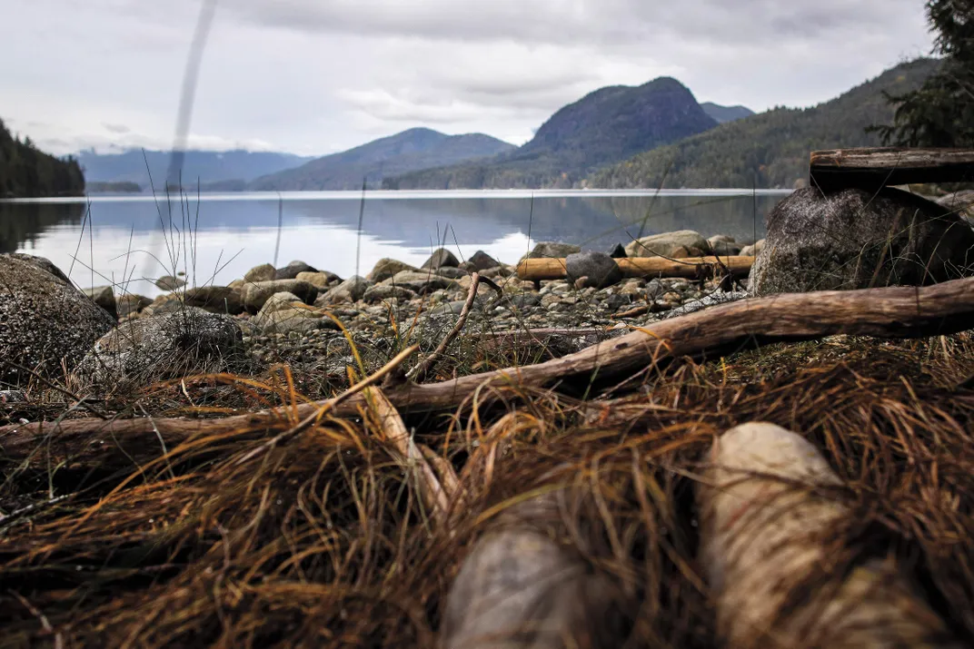
The rugged shoreline of British Columbia is carved by countless coves and inlets and dotted with tens of thousands of islands. On a cool August morning, I arrived on Quadra Island, about 100 miles northwest of Vancouver, to join a group of researchers from the University of Victoria and the nonprofit Hakai Institute. Led by anthropologist Daryl Fedje, the team also included his colleagues Duncan McLaren and Quentin Mackie, as well as Christine Roberts, a representative of the Wei Wai Kum First Nation.
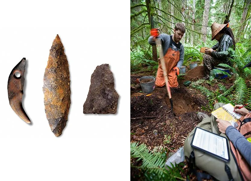
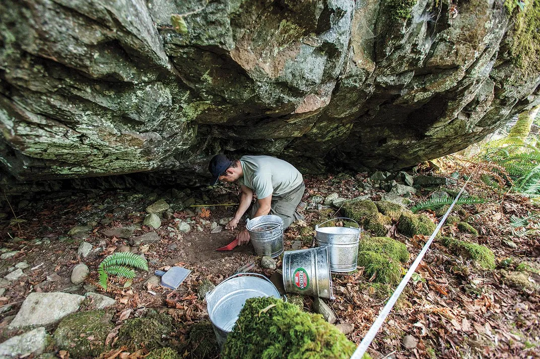
The site was located on a tranquil cove whose shores were thick with hemlock and cedar. When I arrived, the team was just finishing several days of digging, the latest in a series of excavations along the British Columbia coast that had unearthed artifacts from as far back as 14,000 years ago—among the oldest in North America.
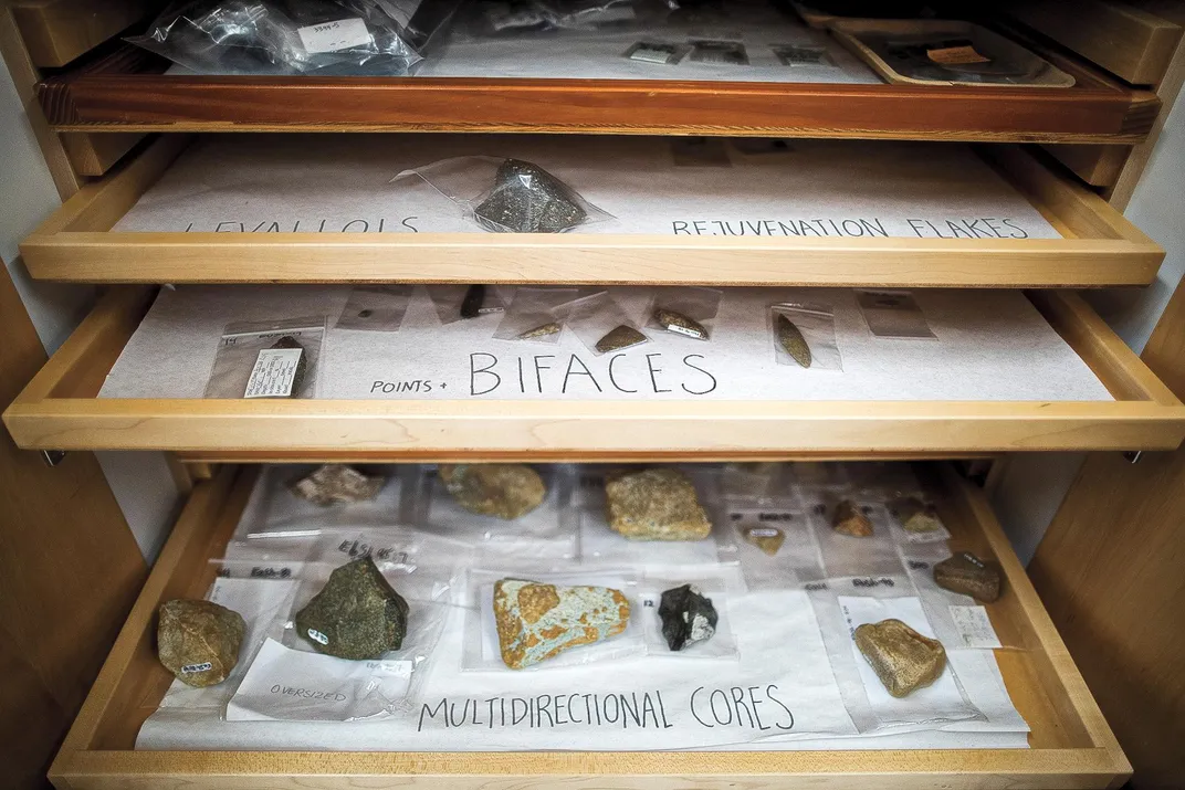
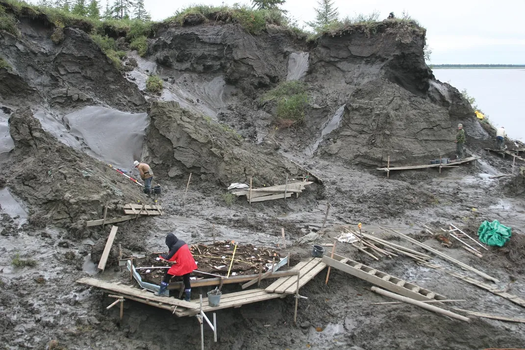
On a cobble beach and in a nearby forest pit that was about six feet deep and four feet square, Fedje and his colleagues had discovered more than 1,200 artifacts, mostly stone flakes, a few as old as 12,800 years. All testified to a rich maritime-adapted culture: rock scrapers, spear points, simple flake knives, gravers and goose egg-size stones used as hammers. Fedje reckoned that the cove site was most likely a base camp that was ideally situated to exploit the fish, waterfowl, shellfish and marine mammals from the frigid sea.
For Mackie, the archaeological riches of the British Columbian coast reveal a key flaw in the original Bering Land Bridge theory: its bias toward an inland, rather than a marine, route. “People say the coast is a wild, nasty environment,” said Mackie, a stoutly built man with an unruly gray beard and battered green hat, as he took a break from using a screen to sift through rock and earth from the Quadra dig site. “But you have lots of food resources. These were the same people as us, with the same brains. And we know that in Japan people routinely moved back and forth from the mainland to the outer islands by boat as long ago as 30,000 to 35,000 years.”
Several recent studies show that as the last ice age began to loosen its grip, portions of the coastline of British Columbia and Southeastern Alaska were becoming ice-free as far back as 17,000 to 18,000 years ago. Fedje and others note that humans walking across the Bering Land Bridge from Asia could have traveled by boat down these shorelines after the ice retreated. “People were likely in Beringia early on,” says Fedje. “We don’t know exactly, but there certainly is the potential to go back as early as 18,000 years.”
Fedje, McLaren and Mackie stressed that one of the main goals of their decades-long investigations has been to document the ancient culture of British Columbia’s indigenous coastal communities. But in the opinion of many of their North American peers, the trio’s cutting-edge techniques for finding coastal sites have also put the men in the vanguard of the search for the first Americans.
* * *
Today, the coast of the Pacific Northwest bears little resemblance to the world the first Americans would have encountered. The lushly forested shoreline I saw would have been bare rock following the retreat of the ice sheets. And in the last 15,000 to 20,000 years, sea levels have risen some 400 feet. But Fedje and his colleagues have developed elaborate techniques to find ancient shorelines that were not drowned by rising seas.
Their success has hinged on solving a geological puzzle dating back to the end of the last ice age. As the world warmed, the vast ice sheets that covered much of North America—to a depth of two miles in some places—began to melt. This thawing, coupled with the melting of glaciers and ice sheets worldwide, sent global sea levels surging upwards.
But the ice sheets weighed billions of tons, and as they vanished, an immense weight was lifted from the earth’s crust, allowing it to bounce back like a foam pad. In some places, Fedje says, the coast of British Columbia rebounded more than 600 feet in a few thousand years. The changes were happening so rapidly that they would have been noticeable on an almost year-to-year basis.
“At first it’s hard to get your head around this,” says Fedje, a tall, slender man with a neatly trimmed gray beard. “The land looks like it’s been there since time immemorial. But this is a very dynamic landscape.”
That dynamism proved to be a blessing to Fedje and his colleagues: Seas did indeed rise dramatically after the end of the last ice age, but along many stretches of the British Columbia coast, that rise was offset by the earth’s crust springing back in equal measure. Along the Hakai Passage on the central coast of British Columbia, sea-level rise and the rebound of the land almost perfectly canceled each other out, meaning today’s shoreline is within a few yards of the shoreline 14,000 years ago.
In order to track ancient shorelines, Fedje and his colleagues took hundreds of samples of sediment cores from freshwater lakes, wetlands and intertidal zones. Microscopic plant and animal remains showed them which areas had been under the ocean, on dry land and in between. They commissioned flyovers with laser-based lidar imaging, which essentially strips the trees off the landscape and reveals the features—such as the terraces of old creek beds—that might have been attractive to ancient hunter-gatherers.
These techniques enabled the archaeologists to locate, with surprising accuracy, sites such as the one on Quadra Island. Arriving at a cove there, Fedje recalled, they found numerous Stone Age artifacts on the cobble beach. “Like Hansel and Gretel, we followed the artifacts and found them eroding out of the creek bed,” Fedje said. “It’s not rocket science if you have enough different levels of information. We’re able to get that needle into a tiny little haystack.”
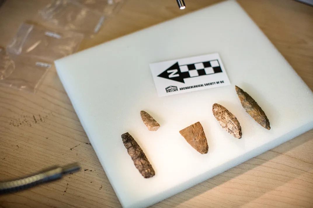
In 2016 and 2017, a Hakai Institute team led by archaeologist Duncan McLaren excavated a site on Triquet Island containing obsidian cutting tools, fishhooks, a wooden implement to start friction fires and charcoal dating from 13,600 to 14,100 years ago. On nearby Calvert Island, they found 29 footprints belonging to two adults and one child, stamped into a layer of clay-rich soil buried under the sand in an intertidal zone. Wood found in the footprints dated back roughly 13,000 years.
Other scientists are conducting similar searches. Loren Davis, an archaeologist at Oregon State University, has cruised from San Diego to Oregon using imaging and sediment cores to identify possible settlement sites drowned by rising seas, such as ancient estuaries. Davis’ work inland led to his discovery of a settlement dating back more than 15,000 years at Cooper’s Ferry, Idaho. That find, announced in August 2019, meshes nicely with the theory of an early coastal migration into North America. Located on the Salmon River, which connects to the Pacific via the Snake and Columbia rivers, the Cooper’s Ferry site is hundreds of miles from the coast. The settlement is at least 500 years older than the site that had long been viewed as the oldest confirmed archaeological site in the Americas—Swan Point, Alaska.
“Early peoples moving south along the Pacific Coast would have encountered the Columbia River as the first place below the glaciers where they could easily walk and paddle into North America,” Davis said in announcing his findings. “Essentially, the Columbia River corridor was the first offramp of a Pacific Coast migration route.”
* * *
An axiom in archaeology is that the earliest discovered site is almost certainly not the first place of human habitation, just the oldest one archaeologists have found so far. And if the work of a host of evolutionary geneticists is correct, humans may already have been on the North American side of the Bering Land Bridge about 20,000 years ago.
Eske Willerslev, who directs the Center for GeoGenetics at the Globe Institute at the University of Copenhagen and holds the Prince Philip chair of ecology and evolution at the University of Cambridge, sequenced the first ancient human genome in 2010. He has since sequenced numerous genomes in an effort to piece together a picture of the first Americans, including a 12,400-year-old boy from Montana, 11,500-year-old infants at Alaska’s Upward Sun River site and the skeletal DNA of a boy whose 24,000-year-old remains were found at the village of Malta, near Russia’s Lake Baikal.
According to Willerslev, sophisticated genomic analyses of ancient human remains—which can determine when populations merged, split or were isolated—show that the forebears of Native Americans became isolated from other Asian groups around 23,000 years ago. After that period of genetic separation, “the most parsimonious explanation,” he says, is that the first Americans migrated into Alaska well before 15,000 years ago, and possibly more than 20,000 years ago. Willerslev has concluded that “there was a long period of gene flow” between the Upward Sun River people and other Beringians from 23,000 to 20,000 years ago.
“There was basically an exchange between the populations across eastern and western Beringia,” Willerslev said in a phone interview from Copenhagen. “So you had these groups hanging around Beringia and they are to some degree isolated—but not completely isolated—from each other. You had those groups up there, on both sides of the Bering Land Bridge, around 20,000 years ago. I think that is very likely.”
This new evidence, coupled with paleoecological studies of Beringia’s ice age environment, gave rise to the Beringian Standstill hypothesis. To some geneticists and archaeologists, the area in and around the Bering Land Bridge is the most plausible place where ancestors of the first Americans could have been genetically isolated and become a distinct people. They believe such isolation would have been virtually impossible in southern Siberia, or near the Pacific shores of the Russian Far East and around Hokkaido in Japan—places already occupied by Asian groups.
“The whole-genome analysis—especially of ancient DNA from Siberia and Alaska—really changed things,” says John F. Hoffecker of the University of Colorado’s Institute of Arctic and Alpine Research. “Where do you put these people where they cannot be exchanging genes with the rest of the Northeast Asian population?”
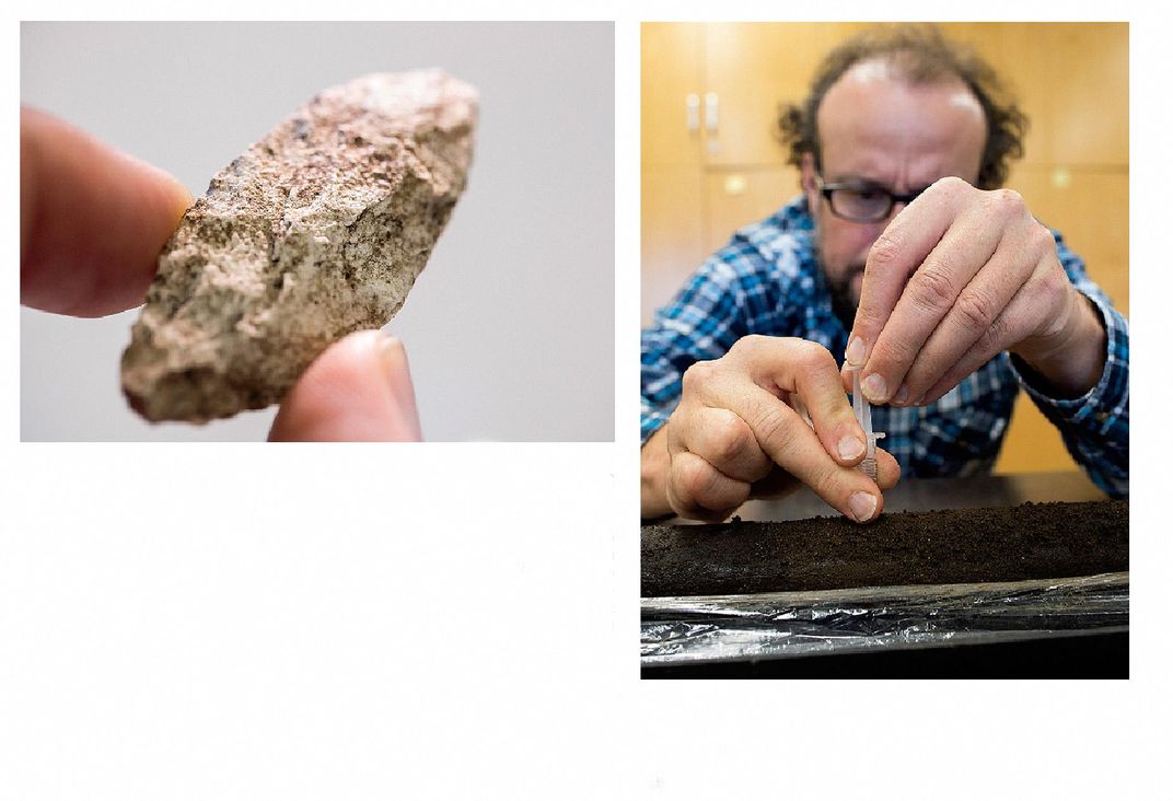
Could humans have even survived at the high latitudes of Beringia during the last ice age, before moving into North America? This possibility has been buttressed by studies showing that large portions of Beringia were not covered by ice sheets and would have been habitable as Northeast Asia came out of the last ice age. Scott Elias, a paleoecologist with the University of Colorado’s Institute of Arctic and Alpine Research, used a humble proxy—beetle fossils—to piece together a picture of the climate in Beringia 15,000 to 20,000 years ago. Digging in peat bogs, coastal bluffs, permafrost and riverbanks, Elias unearthed skeletal fragments of upwards of 100 different types of tiny beetles from that period.
Comparing the ancient beetle fossils with those found on similar landscapes today, Elias concluded that southern Beringia was a fairly moist tundra environment that could have supported a wide variety of animals. He says that winter temperatures in the southern maritime zone of Beringia during the peak of the last ice age were only slightly colder than today, and summer temperatures were likely 5 to 9 degrees Fahrenheit cooler.
“People could have made a pretty decent living along the southern coast of the land bridge, especially if they had knowledge of marine resource acquisition,” says Elias. “The interior in Siberia and Alaska would have been very cold and dry, but there were large mammals living there, so these people may have made hunting forays into the adjacent highlands.”
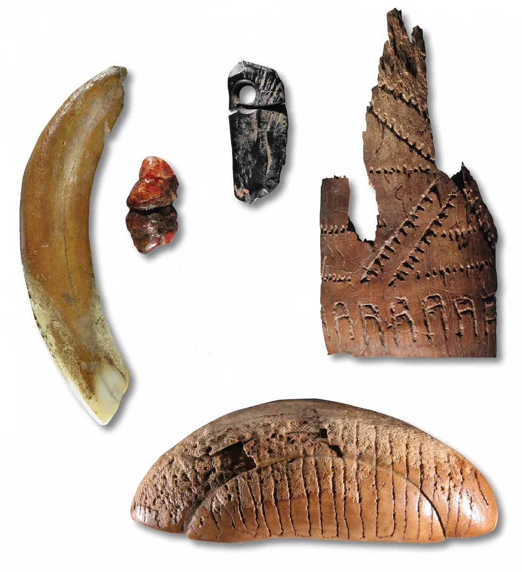
Proponents of the Beringian Standstill hypothesis also point to a cluster of remarkable archaeological sites on Siberia’s Yana River, located on the western edge of Beringia, 1,200 miles from what is now the Bering Strait. Situated well above the Arctic Circle, the Yana sites were discovered in 2001 by Vladimir Pitulko, an archaeologist with the Institute for the History of Material Culture in St. Petersburg. Over nearly two decades, Pitulko and his team uncovered evidence of a thriving settlement dating back 32,000 years, including tools, weapons, intricate beadwork, pendants, mammoth ivory bowls and carved human likenesses.
Based on butchered animal skeletons and other evidence, Yana appears to have been occupied year-round by up to 500 people from 32,000 to 27,000 years ago and sporadically inhabited until 17,000 years ago. Pitulko and others say Yana is proof that humans could have survived at high latitudes in Beringia during the last ice age.
Yet the ones who made it across the Bering Land Bridge were apparently not the people of Yana. Willerslev’s lab extracted genetic information from the baby teeth of two boys who lived at the site 31,600 years ago and found that they shared only 20 percent of their DNA with the founding Native American population. Willerslev believes Yana’s inhabitants were likely replaced by, and interbred with, the paleo-Siberians who did eventually migrate into North America.
Once in the New World, the first Americans, probably numbering in the hundreds or low thousands, traveled south of the ice sheets and split into two groups—a northern and southern branch. The northern branch populated what are now Alaska and Canada, while members of the southern branch “exploded,” in Willerslev’s words, down through North America, Central America and South America with remarkable speed. Such a movement could account for the growing number of archaeological sites dating from 14,000 to 15,000 years ago in Oregon, Wisconsin, Texas and Florida. Far to the south, at Monte Verde in southern Chile, conclusive evidence of human settlement dates back at least 14,500 years.
“I think it has become more and more clear, based on the genetic evidence, that people were capable of much more in terms of spreading out than we thought,” says Willerslev. “Humans are very early on capable of making incredible journeys, of [doing] things that we, even with modern equipment, would find very difficult to achieve.”
In Willerslev’s view, what primarily drove these ancient people was not the exhaustion of local resources—the virgin continents were too rich in food and the numbers of people too small—but an innate human yearning to explore. “I mean, in a few hundred years they are taking off across the entire continent and spreading into different habitats,” he says. “It’s obviously driven by something other than just resources. And I think the most obvious thing is curiosity.”
* * *
Some archaeologists, like Ben A. Potter at the University of Alaska Fairbanks, emphasize that genetics can only provide a road map for new digs, not solid evidence of the Beringian Standstill theory or the settlement of the Americas 20,000 years ago. “Until there’s actual evidence that people were in fact there, then it remains just an interesting hypothesis,” he says. “All that is required is that [ancestral Native Americans] were genetically isolated from wherever the East Asians happened to be around that time. There’s absolutely nothing in the genetics that necessitates the Standstill had to be in Beringia. We don’t have evidence that people were in Beringia and Alaska then. But we do have evidence that they were around Lake Baikal and into the Russian Far East.”
After Potter unearthed the 11,500-year-old remains of two infants and a girl at the Upward Sun River site in Alaska’s Tanana Valley—among the oldest human remains found in North America—Willerslev sequenced the infants’ DNA. The two scientists were co-authors on a Nature paper that “support[ed] a long-term genetic structure in ancestral Native Americans, consistent with the Beringian ‘standstill model.’”
But Potter thinks that news stories on these and other findings have been too definitive. “One of the problems with the media coverage is its focus on a single hypothesis—a pre-16,000-year-old migration along the northwest coast—that is not well supported with evidence.”
Potter remains doubtful that humans could have survived in most of Beringia during the bitter peak of the ice age, about 25,000 years ago. “Across the board,” he says, “from Europe all the way to the Bering Strait, this far north area is depopulated. There’s nobody there, and that lasts for a long time.”
But some scientists retort that the reason no sites older than 15,000 to 16,000 years have been discovered in easternmost Siberia or Alaska is that this sprawling, lightly populated region has seen little archaeological activity. The area now defined as Beringia is a vast territory that includes the present-day Bering Strait and stretches nearly 3,000 miles from the Verkhoyansk Mountains in eastern Siberia to the Mackenzie River in western Canada. Many archaeological sites at the heart of ancient Beringia are now 150 feet below the surface of the Bering Strait.
Ancient sites are often discovered when road builders, railway construction crews or local residents unearth artifacts or human remains—activities that are rare in regions as remote as Chukotka, in far northeastern Siberia. “It means nothing to say that no sites have been found between Yana and Swan Point,” says Pitulko. “Have you looked? Right now there are no [archaeologists] working from the Indigirka River to the Bering Strait, and that’s more than 2,000 kilometers. These sites must be there, and they are there. This is just a question of research and how good a map you have.”
Hoffecker agrees: “I think it’s naïve to point to the archaeological record for northern Alaska, or for Chukotka, and say, ‘Oh, we don’t have any sites that date to 18,000 years and therefore conclude that nobody was there.’ We know so little about the archaeology of Beringia before 15,000 years ago because it is very remote and undeveloped, and half of it was underwater during the last ice age.”
* * *
Five feet down in a pit at a wooded grove on Quadra Island, Daryl Fedje is handing up stone tools with the good cheer of someone hauling heirlooms out of grandmother’s trunk in the attic. From the pit, illuminated by powerful lights suspended from ropes strung between trees, Fedje passes the most promising items to his colleague Quentin Mackie, who rinses them in a small plastic container of water nailed to a tree and turns them over in his hand like a jeweler inspecting precious stones.
“Q, have a look at this,” says Fedje.
Examining a dark stone the size of a goose egg, Mackie turns to me and points out the rock’s pitted end, which is where it was used to strike objects in the toolmaking process. “This has got little facets,” says Mackie. “I’m sure it’s a hammerstone. It’s symmetrical, balanced, a good striking tool.”
Mackie drops the hammerstone into a plastic zip-lock bag with a small piece of paper denoting its depth and location in the pit.
Next up is a two-inch-long gray rock with sharp edges, the chipped planes from the fracturing process clearly visible. “I think what we have here,” says Mackie, “is a double-ended graving tool—you can drill with one end and scribe antler with the other.” It, too, is dropped into a zip-lock bag.
And on it goes, hour after hour, with Fedje and his colleagues pulling roughly 100 stone artifacts out of the pit in the course of a day: a sharp tool likely used to cut fish or meat, the bottom half of a small spear point, and numerous stone flakes—the byproducts of the toolmaking process.
Fedje believes that an especially promising area for archaeologists to apply his group’s techniques is the southeastern coast of Alaska and the northern end of the Gulf of Alaska. “At just five feet above current sea level, you could find places that were great for people 16,000 years ago,” he says.
Ted Goebel, associate director of the Center for the Study of the First Americans at Texas A&M University, says that recent developments in genetics, coupled with the work of Fedje and his colleagues, have spurred his desire to search for early Americans in far-flung reaches of Alaska, including tributaries of the Yukon River and parts of the Seward Peninsula.
“Five years ago I would have told you that you were full of crap if you were suggesting that there were humans in Alaska or far Northeast Asia 20,000 or 25,000 years ago,” says Goebel. “But the more we hear from the geneticists, the more we really have to be thinking outside that box.”
Michael Waters, director of Texas A&M’s Center for the Study of the First Americans, which has found pre-Clovis sites in Texas and Florida, says Fedje and colleagues have come up with “a brilliant strategy” for finding game-changing artifacts where archaeologists have never searched. “It’s some of the most exciting stuff I’ve seen in years,” Waters says. “I’m rooting for them to find that early site.”
Finding Ways
The clues are tantalizing. But proving exactly how humans first reached the Americas is challenging—by Jennie Rothenberg Gritz
As scientists debate the peopling of the Americas, it’s worth noting there could be more than one right answer. “I think current evidence indicates multiple migrations, multiple routes, multiple time periods,” says Torben Rick, an anthropologist at Smithsonian’s National Museum of Natural History.
Rick began his own career studying a likely migration along the “Kelp Highway”—the rim of coastline that apparently once stretched from Asia all the way around to North America.
“People could basically stair-step their way around the coast and have a similar suite of resources that they were in general familiar with,” says Rick, who has spent years excavating sites on the California coast. Rick’s late Smithsonian colleague Dennis Stanford famously advocated the Solutrean hypothesis, which claims the first Americans came over from Europe, crossing the ice of the North Atlantic. Rick isn’t sold on the idea, but he praises Stanford’s willingness to explore an unusual notion: “If we don’t look and we don’t test it and don’t rigorously go after it, we’ll never know for sure.”
Regarding sites in South America that date back more than 14,000 years, could humans have traveled there by boat, perhaps from Oceania? It’s a question
researchers have had to consider. But, Rick says, the theory “doesn’t pass the smell test” because it’s unlikely that people then were capable of crossing an open ocean.
Still, he notes that scientists don’t know much about prehistoric watercraft because they were made of perishable materials. “We can say, ‘Ha-ha, that idea doesn’t work’—but I can’t tell you exactly why those early sites are there,” he admits. “Human ingenuity is incredible. I would never underestimate it.”