:focal(3330x1654:3331x1655)/https://tf-cmsv2-smithsonianmag-media.s3.amazonaws.com/filer/f2/5b/f25b1897-57e1-4c97-ba51-8949403cd71f/nov19_fea_geospieswwii64-65_copy.jpg)
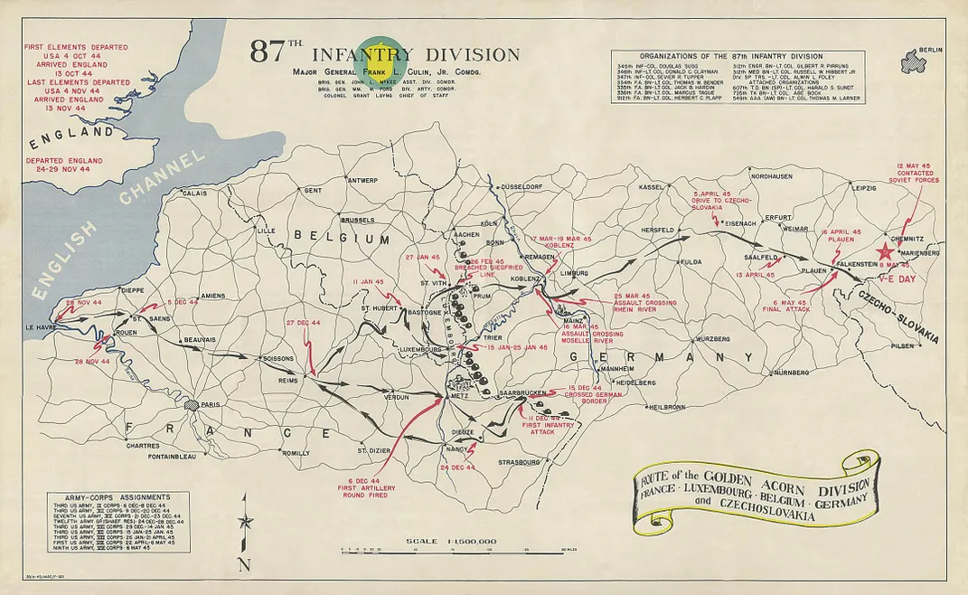
The fighting for Aachen was fierce. American planes and artillery pounded the Nazi defenses for days. Tanks then rolled into the narrow streets of the ancient city, the imperial seat of Charlemagne, which Hitler had ordered defended at all costs. Bloody building-to-building combat ensued until, finally, on October 21, 1944, Aachen became the first German city to fall into Allied hands.
Rubble still clogged the streets when U.S. Army Maj. Floyd W. Hough and two of his men arrived in early November. “The city appears to be 98% destroyed,” Hough wrote in a memo to Washington. A short, serious man of 46 with receding red hair and wire-rimmed glasses, Hough had a degree in civil engineering from Cornell, and before the war he led surveying expeditions in the American West for the U.S. government and charted the rainforests of South America for oil companies. Now he was the leader of a military intelligence team wielding special blue passes, issued by Supreme Headquarters Allied Expeditionary Force, that allowed Hough and his team to move freely in the combat zone. Their mission was such a closely guarded secret that one member later recalled he was told not to open the envelope containing his orders until two hours after his plane departed for Europe.
In Aachen, their target was a library.
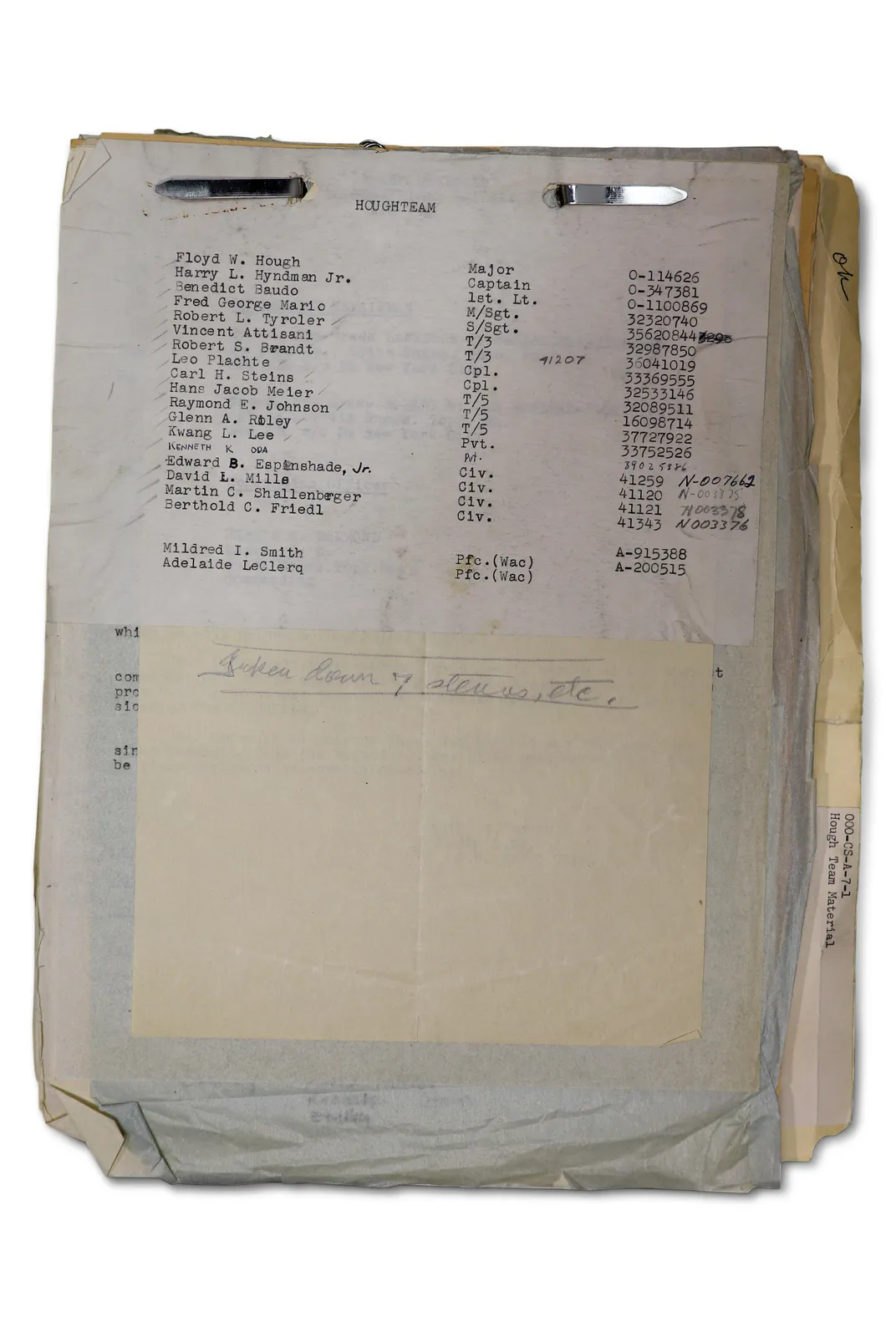
HOUGHTEAM, as the unit was known, was made up of 19 carefully selected individuals. Four were highly educated civilians: an engineer, a geographer who had worked as a map curator at the University of Chicago, a linguist who spoke five languages, and the dapper son of an prominent Kentucky family who’d grown up mostly in Europe as the son of a brigadier general posted to various capitals as a military attaché. There were also ten enlisted men. One was a Japanese interpreter on loan from the Office of Strategic Services, the spy agency precursor to the CIA. Others had been through the secret Military Intelligence Training Center at Camp Ritchie, Maryland. Among the Ritchie Boys, as they were known, were European immigrants who had fled to the United States to escape Nazi persecution. At Camp Ritchie they received training in interrogation and other psychological operations. Their job was to question European civilians about the movement of enemy troops, translate captured documents and interrogate prisoners of war. For the refugees among them, it was a chance to leverage their language skills and cultural familiarity to defeat the enemy that had uprooted their lives.

Detail: Early in his career, Hough led survey parties across the American West, including a 1921 trip to Arizona (Hough is at right). The National Archives: National Oceanic and Atmospheric Administration
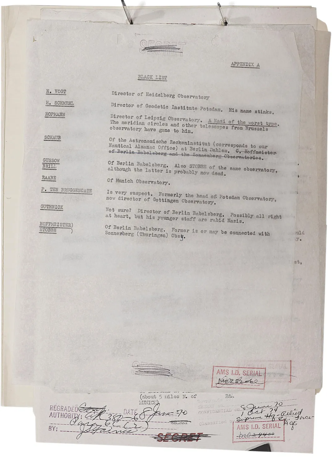
Along with 1,800 pounds of cameras and other equipment for creating microfilm records, HOUGHTEAM also carried 11,000 index cards detailing the holdings of the Army Map Service as well as numerous target lists of technical universities, government institutes, libraries and other places likely to have the materials they had been sent to capture. The lists also named German scientists who seemed likely to cooperate, and some who were not to be trusted.
In Aachen, the library that Hough was looking for was at the Technische Hochschule, or technical university. Though it had been nearly wrecked by American bombs, thousands of books remained. But what caught Hough’s attention were the bundles of folders stacked outside. It appeared as if the Germans “had left a number of files all roped up ready to load onto trucks when they made a hasty exit,” Hough wrote. The abandoned documents included tables of exceptionally precise survey data covering German territory that the Allies had yet to reach—just what Hough was looking for. His team quickly microfilmed the material and sent it to the front, where Allied artillery units could immediately use it to improve their targeting.
The Aachen seizure was the first in a series of remarkable successes for HOUGHTEAM that promised not only to hasten the end of the war but also to shape the world order for decades to come. Little is publicly known about the true scope of the information that Hough and his team captured, or the ingenuity they displayed in securing it, because their mission was conducted in secret, and the technical material they seized circulated only among military intelligence experts and academics. But it was a vast scientific treasure—likely the largest cache of geographic data the United States ever obtained from an enemy power in wartime. Relying on Hough’s memos to his superiors in Washington and other declassified records about the mission, which are stored at the National Archives, in addition to private letters and other materials provided by the families of several team members, I have pieced together the outlines of this historic military feat. The operation seems all the more astonishing because it was executed by an unlikely band of academics, refugees, clerks and soldiers, all led by Hough, an Ivy League-trained engineer with a passion for geodesy, the centuries-old science of measuring the Earth with utmost mathematical precision.
In 20th-century warfare, men and machines could achieve only so much without exact location data to guide them. The Americans knew that the Germans had a trove of this material, and had most likely captured even more of it from the countries they had invaded, including the Soviet Union. If Hough and his team could exploit the chaos of war to hunt down this prize, they would not only help to finish off the Nazis but could give the Americans an incalculable advantage in any global conflict to come.
Hough’s orders, then, were to follow the front, and ride the first tank into Berlin.
* * *
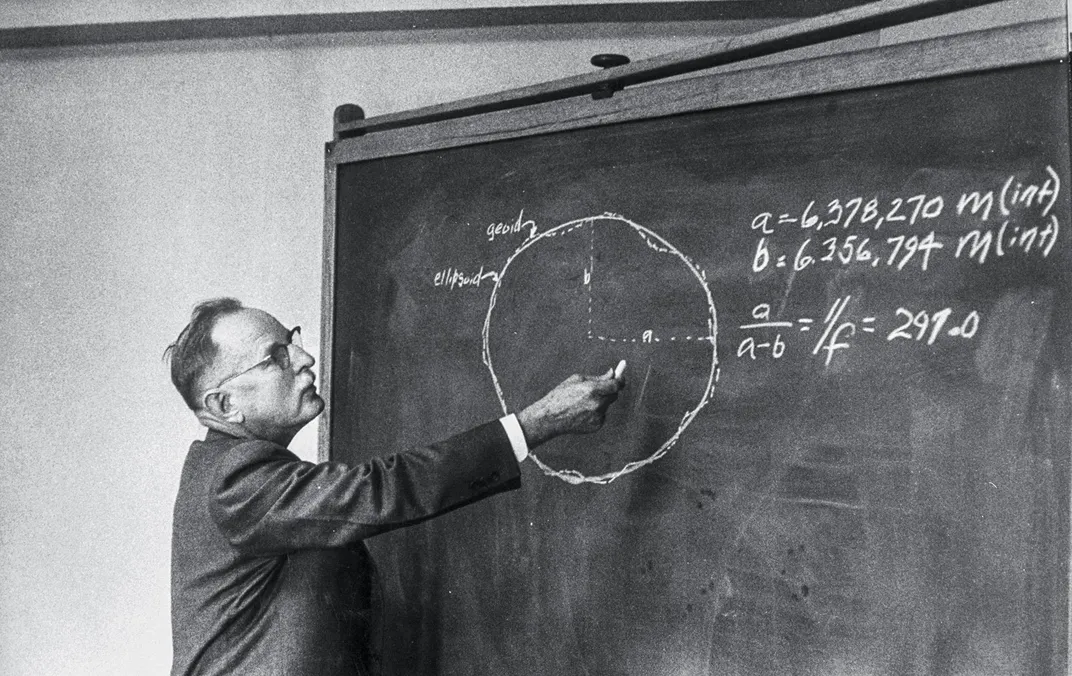
These days, when the phone in your pocket pinpoints your location in seconds, it’s easy to forget just how new that technology is—the U.S. military launched its first GPS satellite only in 1978—and just how laborious it used to be to gather and synthesize definitive geographic data. Unlike a traditional survey used to determine property lines or mark the route for a new road, a geodetic survey of a region accounts for the curvature of the Earth and even variations in this curvature. That extra precision becomes more critical over long distances. The nature of combat in World War II gave geodesy new urgency, as it required coordinating air, ground and naval forces across far larger areas than ever before.
Captured data could give the Americans a pivotal advantage in realizing what would become one of geodesy’s ultimate goals—creating a unified geodetic network that covered the entire globe. In such a system, any point on Earth’s surface could be defined by numerical coordinates, and its distance and direction from any other point calculated with precision. This capability would prove incredibly useful for any long-distance human endeavor, including guiding missiles to a target on another continent, as the Cold War would soon demand.
Not long after the fall of Aachen, the Allies’ military situation worsened. In December of 1944, the Germans mounted a counteroffensive, pushing through the Allied line in southern Belgium and Luxembourg in what became known as the Battle of the Bulge. Foul weather initially grounded the Allies’ superior air power, and the fighting dragged on into January.
Hough waited in Paris. The weather was miserable. Electricity was intermittent. The enlisted men relied on fireplaces for heat—when they could find coal or wood to burn. Everyone seemed to have a cold they couldn’t shake. HOUGHTEAM did what research they could in France and other friendly or neutral countries. They worked six days a week, mostly nibbling at the edges of the real mission, but made the most of their downtime.
Raymond Johnson, a 24-year-old telephone company lineman from Chicago, explored the movies and cabarets of Paris and practiced a few words of French with local women, as he later wrote in an unpublished memoir his daughters shared with Smithsonian for this article. Berthold Friedl, a 46-year-old linguist who struggled to make small talk with the enlisted men when the group gathered in the evenings to drink wine, wrote a book in French about Soviet military strategy and philosophy of war that was published in 1945. “Dr. Friedl was not capable of idle chit-chat,” Johnson recalled.
Martin Shallenberger, 32, the Kentucky blue blood, spoke fluent German and French, and though he could be charming, the G.I.s found him arrogant, according to Johnson. They bristled when he made them wait while he paused to capture some scene with his Leica camera or the watercolor paint set he carried around.
David Mills, a mild-mannered geodetic engineer, and Edward Espenshade, the geographer, were more at ease with the G.I.s. Espenshade collected rare books, especially pornographic ones, which he left out for all to inspect, including Mildred Smith, one of two Women’s Army Corps members on the team. A geography teacher from Illinois, Smith was brought on for clerical support, but Hough took note of her initiative and intelligence and assigned her to search the map shops of Paris, and later sent her on a research trip to London. The enlisted men called her Smitty. Some, like Johnson, had never met such a woman. “Up to this point in my life I had had little personal contact with the liberated type of woman who could read our underground books and discuss them with the men with perfect composure,” he wrote.
Hough remained busy. When the Belgians requested help microfilming some survey data and secret lists of artillery coordinates, he was happy to oblige—and saw to it that an extra copy was sent to Washington without the Belgians’ knowledge. When the French city of Strasbourg was recaptured by the Allies, his men removed a cache of top-quality German survey equipment before the French had a chance to claim the gear for themselves.
If an obstacle arose, Hough was willing to get creative. After several neutral countries balked at letting Espenshade and Shallenberger search their institutes and libraries, Hough procured letters from the Library of Congress certifying the men as its representatives engaged in bibliographic research. A similar ploy got Shallenberger into the pope’s private library at the Vatican, which was strictly off-limits to members of any military, owing to the Vatican’s status of neutrality.
Finally, by early March, the Allied forces resumed their eastward progress and were poised to cross the Rhine into the German heartland. HOUGHTEAM’s window of opportunity was opening.
* * *
On March 4, Hough left Paris with Mills, his fellow engineer, and three enlisted men. They entered Cologne on March 7, and, the next day, toured the captured city’s massive Gothic cathedral, seemingly the only building to have escaped Allied bombing. On March 9, they received word that Bonn had been captured, and they made it there by nightfall. There they interrogated the director of the local geodetic institute, who led them to a hidden alcove that held a box of valuable books. The man claimed he’d stashed the materials there despite orders to evacuate them across the Rhine. “It is surprising that these Germans cooperate as they do,” Hough wrote in his daily memo to his superiors in Washington. Whether the scientist was anti-Nazi or was simply afraid of what the Americans might do to him, Hough wasn’t sure.
Hough and his men entered Frankfurt at the end of March, the day after it was captured, taking shelter in one of the few structures still standing in the business district. Buildings were still burning. Water was scarce. They found some in two bathtubs the Germans hadn’t drained before fleeing. But HOUGHTEAM’s target institutions in Frankfurt had been reduced to rubble. In the basement of one building, the men saw what looked like books, but they disintegrated into fine ash in their hands.
In Wiesbaden, a city just to the west, their luck began to improve. In the basement of one building, they found 18 bundles of survey data, hidden behind a pile of rubbish. Marked “Secret” or “Confidential” in German, the sheets covered thousands of survey points in southwestern Germany. The data had immediate operational value for the U.S. Seventh Army, which was beginning to push its way across the Rhine into that area. Hough decided to shortcut the chain of command to get the information directly to the artillery units that could use it.
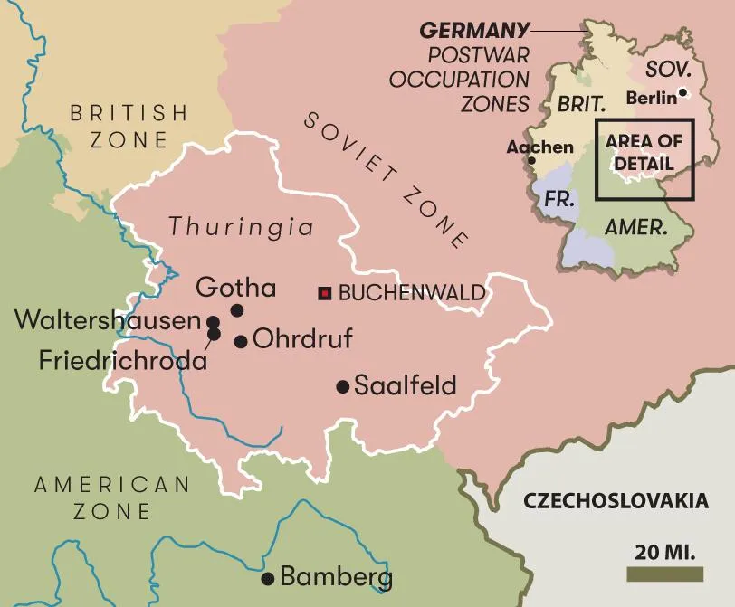
Hough and his team also got a tip from a captured officer of the Reichsamt für Landesaufnahme, or RfL, the German national survey agency; he revealed the names of two small towns, about 140 miles to the east in Thuringia, a hilly, forested region dotted with medieval villages, which had not been on any of Hough’s target lists.
The U.S. Third Army was just moving into the area, which was famed for its artisanal bisque dolls, named for the unglazed porcelain that gave them a lifelike appearance. On April 10, Hough headed east with four enlisted men. In the small towns of Friedrichroda and Waltershausen, dispersed among three doll factories, private homes, a ranch house and a stable, the team found the entire archive of the RfL, which represented the German government’s best survey data of its own territory. The documents had been spirited from Berlin and hidden. It was by far the team’s biggest haul to date. “Cannot begin to estimate yet what is here but it is plenty,” Hough wrote.
On April 12, Hough and several of his men visited Ohrdruf, a subcamp of the infamous Buchenwald complex, and the first Nazi concentration camp liberated by American forces, just eight days earlier. Generals Dwight Eisenhower and George Patton visited Ohrdruf on the same day as Hough. “There are no words capable of expressing the horrible scenes on every hand,” Hough wrote. “It was revolting and we were left almost speechless.”
That night, Johnson and a few other HOUGHTEAM enlisted men stayed in a home in the nearby city of Gotha. In that stage of the war it was common practice for the Army to billet the troops in commandeered civilian homes. Johnson was struck by how familiar they felt. “They were charming and comfortable,” he recalled in his memoir. “Plants in the windows, closets full of clothes, children’s rooms with toys in them, sewing articles, cabinets full of good china and silver.” It seemed impossible to reconcile these cozy scenes of German domestic life with the horrors they had witnessed. One of the men sat vacantly burning holes in the upholstered arm of a chair. “There was nothing we could do that could measure up to the enormity of what we had seen,” Johnson wrote.
Days later Hough and his men interrogated several captured RfL officials, including the institute’s president, Wilhelm Vollmar, who tried the Americans’ patience and spent a night in jail as a result. Erwin Gigas, the chief geodesist, was more cooperative. A third German, whom Hough identifies only as “the real man we were interested in,” proved of more immediate value. They’d been searching for him since Wiesbaden.
One of the Ritchie Boys, Hans Jacob Meier, the team’s ace German interrogator, led the questioning. Meier was a gregarious immigrant in his late 30s who ran a deli in New York City. But he also had a reputation among the team as a shadowy figure, who would disappear for days on mysterious errands only to show up at exactly the agreed-upon time and place. For German-born Ritchie Boys, returning to their homeland came with the risk of running into someone they’d known in their previous life, so Hough and the other men referred to him as “Corporal Liford” to conceal his identity.
The captive was reluctant to cooperate. When the questioning grew pointed, the subject “turned several colors and refused to answer,” Hough wrote. They waited in silence. Meier threatened to have the man arrested on the spot. If more explicit threats were made or more aggressive tactics employed, Hough makes no mention of it. At long last, the captive blurted out a name: Saalfeld.
* * *
Saalfeld was about 50 miles to the southeast of HOUGHTEAM’s position. Hough, Mills and five enlisted men arrived on April 17, four days after the U.S. 87th Infantry Division captured the town. The train station and nearby factories had been bombed, and several fully loaded freight cars were in the process of being looted. Some of the dead had yet to be buried. The 87th had kept on rolling to the east without pausing to set up a military government.
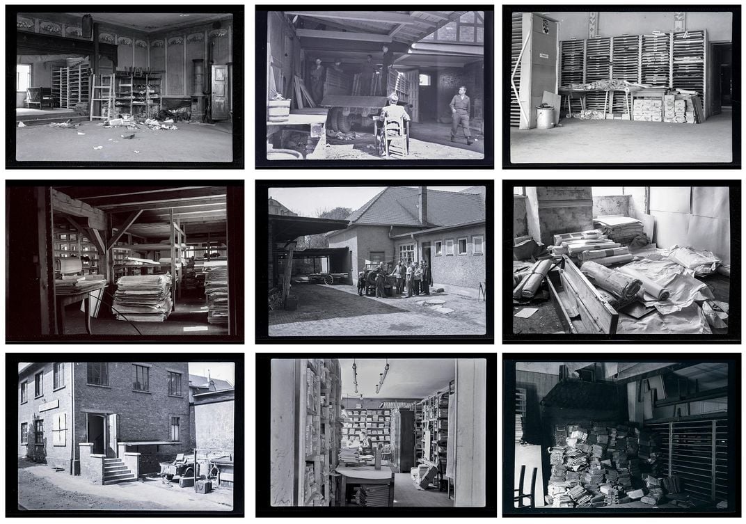
Hough and his men assumed authority for the town and met with the mayor and three other leaders, who, Hough wrote, “seemed to be delighted to see some Allied uniforms around.” Hough wasted little time in bringing up the information his team had received about a possible stash of data. They were led down an alley to a warehouse. Inside was a room 30 feet long by 50 feet wide. Shelves nearly reaching the ceiling were filled with stacks of paper.
They had found nothing less than the central map and geodetic data repository for the German Army—the mother lode. The records of the German military, unlike those of the mostly civilian RfL, extended well beyond Germany’s prewar borders, into Eastern Europe and the Soviet Union. The material had been moved from Berlin to save it from Allied bombs.
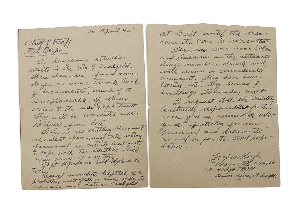
Hough wrote an urgent letter to an Army corps chief of staff. “A dangerous situation exists in the city of Saalfeld,” he began. “There have been found some dozen or more truckloads of documents, much of it irreplaceable, of extreme value to the War Department.” He requested the immediate dispatch of at least 150 men to secure the town—not only to protect his men and their captured material but for the benefit of the townspeople as well.
There was barely time to take stock of everything. Hough and his men spent the night in the warehouse to safeguard their discovery. The immediate concern was roaming bands of Soviet and Polish refugees, recently liberated from nearby forced labor camps and now taking revenge by looting homes and buildings and setting fires. Hough estimated there were 4,000 of them, many of them drunk, some of them armed. If they got to the warehouse, Hough and his men would be poorly equipped to defend it.
By now the Red Army was attacking Berlin. The war would soon be over, and another problem for Hough was that Saalfeld was well inside the soon-to-be-Soviet occupation zone, as previously agreed upon by the Allied nations. In other words, the town would have to be turned over to the Soviets at the end of the war. If Hough didn’t get the maps and data out quickly, the Americans would never see them again.
In the following days, Hough and his men put together a major transport operation. He borrowed trucks, small planes and enlisted men from U.S. Army units in the area, and conscripted dozens of German civilians to help with the loading. By May 8, the day Germany officially surrendered, they had shipped 35 two-and-a-half-ton capacity truckloads of maps, data and instruments 75 miles south, to Bamberg, a town safely within the American occupation zone. By June 1, they’d moved 250 tons of captured material safely out of Saalfeld and elsewhere in Thuringia.
In Bamberg’s city hall, Hough established a new headquarters for the team, and commandeered nearly an acre of storage space for sorting the captured material. The team culled this to 90 tons of maps, aerial photographs, high-quality geodetic survey instruments and reams of printed data, which they packed into 1,200 boxes to be shipped to the Army Map Service in Washington.
The haul included complete geodetic coverage of more than a dozen European countries and states, including Russia, and several more in North Africa and the Middle East. Hough later estimated that 95 percent of this data was new to the U.S. military. It also included approximately 100,000 maps covering all of Europe, Asiatic Russia, parts of North Africa, and scattered coverage of other parts of the world.
The Soviets took possession of Saalfeld on July 2. HOUGHTEAM was still moving material out of the region on July 1.
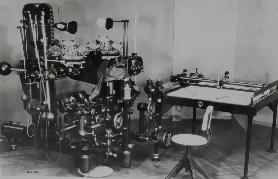
The team also captured seven giant contraptions called stereoplanigraphs—cutting-edge technology used to create topographic maps from aerial photos. Bristling with knobs and adjustable arms, each machine was big enough to fill a room and required two people to operate. A complex interior system of lenses and filters combined images from overlapping aerial photos to make high-precision measurements of elevation differences between hills and valleys and other features of the terrain. The models captured in Saalfeld were made by Zeiss, the renowned German optics firm; Hough estimated their combined value at $500,000 (nearly $7 million today). He ordered a furniture factory in Saalfeld to build shipping crates, and sent one of his officers to fetch an engineer from Zeiss headquarters to oversee the disassembly and safe packing of the precious optical equipment.
One Sunday in late May, with most of the material from Saalfeld safely relocated to the American zone, Hough finally gave his men a day off. It was their first since March. After the intense rush of the past few weeks, Hough, too, must have needed a chance to rest. In his memos, he noted that they’d had a stretch of pleasant spring weather, and the countryside of southern Germany looked beautiful. German soldiers could be seen on the streets, shuffling their way home, still wearing their uniforms and carrying their packs.
* * *
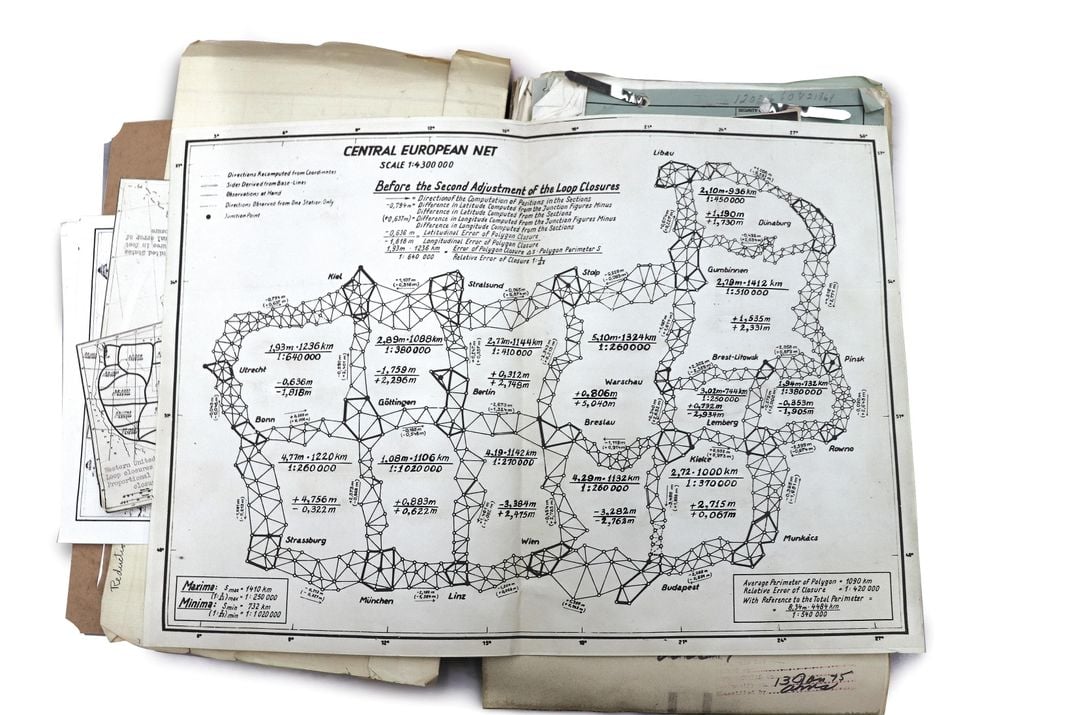
The end of the war did not slow Hough down. He already had a vision for what to do with the captured material, and in Bamberg he quickly got to work. Geodesists had recently begun to aspire to an ambitious new goal: creating a geodetic network, or “datum,” covering the entire world. In 1945, this was still a distant dream. Europe alone was a patchwork of roughly 20 datums. Each country, sometimes even individual regions within a single country, had performed its own surveys, often using different mathematical methods.
Yet the raw data needed to create a Europe-wide datum existed—and Hough now had much of it. Massive number-crunching would be required to make it useful. So in mid-May, Hough moved RfL geodesist Erwin Gigas to Bamberg, along with several of his former computational staff. There the Germans performed the thousands of calculations required to integrate survey data covering a vast swath of Central Europe into a single geodetic datum. Hough arranged for the geodesists to receive room and board in German homes and paid them the salary they’d been receiving from the German government. As the group grew, Allied counter-intelligence officers vetted each new member, barring anyone suspected of Nazi sympathies.
The rest of HOUGHTEAM kept at it. Shallenberger and Espenshade uncovered maps and data hidden inside salt mines and castles and even buried amid human bones in the graveyard of a monastery. They discovered the map collection of the German state department, the aerial photo archives of the Luftwaffe, and various innovative German devices and processes related to mapmaking.
Shallenberger also captured the German general in charge of maps and surveys for the Nazi military, Gerlach Hemmerich. The U.S. Army had commandeered Hemmerich’s home, in Berlin, but on a hunch Shallenberger paid a visit. He noticed that the German cook used the formal version of the language, usually spoken only by highly educated people. After questioning, the woman admitted that she was Hemmerich’s wife, and said that she and her husband had been living in the house all along. The general had recently taken a job stoking furnaces at a U.S. Army installation; when he returned home from work, Shallenberger and an armed escort took him into custody.
With their mission winding down, Hough made time to draft letters recommending his team members for promotions and new jobs. He recommended Meier, the German-born interrogator, for a two-grade promotion, and later a Bronze Star, crediting him with uncovering information that led directly to many of the team’s greatest discoveries. “It is known through German sources that much of this work was done at considerable risk to his life, both at the time and in the future,” Hough wrote.
Hough finally returned to Washington in September 1945 and resumed his position as head of the Geodetic Division of the Army Map Service. By the time Gigas and his group completed their work on the Central European datum, in 1947, Hough, who’d continued to travel to international conferences to meet with foreign geodesists, had laid the diplomatic groundwork for connecting the rest of Europe to the geodetic network. When several countries that had been invaded by the Nazis understandably refused to turn over their national survey data to the German geodesists, Hough persuaded the Army Map Service to take over the project. The work reached a culmination in 1951, with the completion of the European Datum, or ED50, which united the continent in a common geodetic network for the first time.
The ED50, in turn, became part of the foundation for a new global coordinate system known as the Universal Transverse Mercator, the standard coordinate system used by the U.S. military and NATO. It soon proved equally useful for civilian operations, and was adopted for applications as varied as economic development projects, ecological research and oil prospecting. William Rankin, a historian of science at Yale and author of the 2016 book After the Map: Cartography, Navigation, and the Transformation of Territory in the Twentieth Century, says the Universal Transverse Mercator was a crucial step along the path from old-fashioned maps, which represented territory in an intuitively visual way, to coordinate systems such as GPS, which define locations with much greater numerical precision. UTM showed “how to think differently about space and location using mathematics,” Rankin says. “It was like GPS—before GPS.”
Despite their accomplishments, the exploits of HOUGHTEAM have been only briefly noted by a handful of historians, and their story has been largely forgotten even within the military geospatial community. “We’re used to working in secret and going unrecognized for our contributions to national security,” says Thom Kaye, a military cartographer who only learned of Hough’s story a few years ago, after he happened upon a reference in a history of Cold War cartography. Kaye began lobbying for Hough to be inducted into the Hall of Fame of the National Geospatial-Intelligence Agency. Hough, who died in 1976 at age 77, received this posthumous honor last year.
According to Gary Weir, the agency’s official historian, the data captured by HOUGHTEAM was an enormous boon to the U.S. during the Cold War. The ability to target Red Square with an intercontinental ballistic missile launched from a silo in Montana requires a level of precision that can only come from geodesy. As it happened, the Saalfeld haul included Russian geodetic survey data the Germans had in their possession—data that HOUGHTEAM moved to the U.S. “If we wanted to put ordnance on target, this is exactly the data you needed to do it,” Weir says. Perhaps not surprisingly, Hough played an early role in developing the Army’s program of research for guided missile systems.
In the paranoid days of mutually assured destruction, it mattered not only that we had this data, Weir says, but also that the Soviets knew we had it. And they did. In 1957, according to an article published the following year in Life magazine, Hough met a number of leading Soviet geodesists at a conference in Toronto. Upon being introduced by colleagues, one of the Russian delegates eyed Hough coolly and said, “We have heard a lot about you, Mr. Hough.”
This story was produced in partnership with Atellan Media and Six Foot Press.