Footpath Atop the West
Since the 1930s, the 2,650-mile Pacific Crest Trail, extending from Mexico to Canada, has beckoned young and old
/https://tf-cmsv2-smithsonianmag-media.s3.amazonaws.com/accounts/headshot/Don4x5.tif)
/https://tf-cmsv2-smithsonianmag-media.s3.amazonaws.com/filer/Footpath-Atop-West-388.jpg)
From 8,000 feet up the side of San Jacinto Peak in Southern California, Interstate 10, at the base of the gorge, snakes through the San Bernardino Mountains and enters the Mojave Desert. Ahead of me to the north rises the snowcapped cone of 11,502-foot San Gorgonio Peak, the tallest mountain in Southern California. The sprawling Los Angeles Basin is northwest and, somewhere beyond, the Pacific Ocean.
That I was able to take in such an astonishing vista at twilight on a cool autumn evening can be traced to a visionary idea, conceived in 1926, that led to the creation of the Pacific Crest National Scenic Trail (PCT), a 2,650-mile high-country footpath extending from the U.S.-Mexico border to Canada. Like its better-known East Coast equivalent, the 2,100-mile Appalachian Trail, the PCT constitutes one of the most extraordinary wilderness treasures in the nation.
It is layered with history, crisscrossing many of the California peaks and canyons that naturalist John Muir trekked in the 1860s and '70s, and the Yosemite backcountry immortalized by photographer Ansel Adams. There's even the stretch in Washington's Cascade Mountains where Supreme Court Justice William O. Douglas was thrown from his horse and broke 13 ribs—necessitating hospitalization and preventing his attendance at the court's opening session in October 1949. "Growing up in Washington State, the PCT was the quintessential experience for our backpacking forays," says U.S. Forest Service official Tim Stone, trail manager for the footpath.
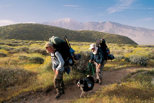
Demanding though certain segments are—the glaciers of the High Sierra, for instance—much of the PCT is surprisingly manageable, with gradual inclines that allow backpackers, in some places, to trek twice the distance they could manage in a day on the Appalachian Trail. This accessibility lures day hikers as well, perhaps 10,000 or so each year.
It's not all breathtaking scenery. Beginning late in 2003, a series of natural disasters—from catastrophic forest fires to torrential floods—hit the ridgeline. For the first time since the PCT was proposed 73 years ago, a leg of it, 45 miles long, has virtually ceased to exist, washed out by a deluge in Washington State's Cascade Mountains. "We knew almost immediately," says Stone, "that the most remote, the most inaccessible section of the trail was gone."
It was Catherine Montgomery, a 59-year-old teacher from Bellingham, Washington, who came up with the notion of a ridgeline track from Canada through the mountains of Washington, Oregon and California to Mexico. She saw "a high trail winding down the heights of our western mountains with mile markers and shelter huts."
Within a few years, Clinton Clarke, a California publisher, philanthropist and outdoorsman, had embraced the idea and proposed it to the U.S. Forest Service and to the National Park Service. In March 1932, he published the first Pacific Crest Trail handbook. Although his descriptions could be sketchy ("The trail goes east of Heart Lake, then south across granite fields..."), the guide vastly increased the trail's popularity. For the next four summers, Civilian Conservation Corps workers and YMCA youngsters began constructing it.
in 1970, an 18-year-old "southbounder," Eric Ryback, became the first person to walk the entire route. He published an account of his north-to-south trek, The High Adventure of Eric Ryback, a year later. The book instilled a fascination with the PCT in many a reader, including me, who came across it as a sixth grader.
Traversing the length of the PCT was not easy then—or now. Thirty-five years after that first through-hike summer, only 800 individuals are known to have made it all the way, some 1,445 fewer than have conquered Mount Everest.
"I'll tell you why PCT through-hikers are so rare," says Jim Hilton, 70, a Seattle attorney who walked it from Mexico to Canada—considered the easier direction—in 1988 with his wife, Peggy. "The PCT requires three to seven months of daily dedication. Every day, you have to get a minimum of 20 miles behind you, or you won't make it to Canada before the snow flies. And it's incredibly demanding. Mount Everest goes—what?—five miles into the sky? While you're traveling 2,600 miles south to north on the PCT, you also make 85 miles in elevation changes. Think about it: not only are you hiking 2,600 miles, you're climbing 85 miles straight up!"
My own truncated trek began at the Mexican border, a mile south of Campo, California, a hamlet of 3,122. There, on a desert hillock edged by a six-foot-tall fence running east to west along the Mexican border, an unprepossessing stand of five 12-by-12-inch cedar posts marks the trail's beginning: SOUTHERN TERMINUS PACIFIC CREST NATIONAL SCENIC TRAIL. ESTABLISHED BY ACT OF CONGRESS ON OCTOBER 2, 1968.
I set off on foot, north across the desert. The vegetation edging the trail is chest-high and thorny; each of my footsteps erupts in a puff of dust. Although it is late November, the sun is hot; I am glad I carry a canteen. I am completely alone; there is not even so much as another boot print in the powdery dirt.
I see evidence of the fires that devastated the PCT a few months before, inside Mount Laguna Recreation Area, an hour east of San Diego in the Cleveland National Forest. Golden grasses sway in the shade of black oaks; in the distance, mountains and deep valleys stretch to the horizon.
Then, as I crest the brow of a hill, I confront a wasteland: everything has been blackened by fire. The landscape is not merely singed—it is saturated in an intense, unsettling ebony. The catastrophic Cedar Fire of October and November 2003 devastated more than 100,000 acres here.
It takes me several days of hard hiking to leave the charred landscape entirely behind. Then, late one afternoon, I reach a stretch of trail high above Idyllwild (pop. 3,583), in the San Bernardino National Forest east of Los Angeles. To the west, the sun is sinking low. Suddenly, above the smoggy haze of the San Fernando Valley and Los Angeles beyond, a kind of shimmer glows in the distance. Soon, the light is blinding: the sun, sliding toward the horizon, glances off the surface of the Pacific, perhaps 70 miles away. A sudden flash meets my gaze—some 9,000 feet above sea level.
Between the trail where I stand and the shoreline of the Pacific, this stretch of California is inhabited by perhaps 17 million people. Not one of them, it occurs to me, has the privilege of taking in this view. According to through-hikers, I am experiencing a moment invested with "trail magic."
Pester any PCT trail hiker long enough and he or she will divulge a trail-magic story. Most will also claim there are places where this elusive force concentrates. It may be found, they maintain, in the vicinity of "trail angels"—those largely anonymous individuals who, in fealty to the PCT, spend their own time and effort repairing trail washouts, lugging gallons of water into arid campsites (one day to be used by grateful through-hikers) and providing all manner of assistance and shelter.
Trail angels Jeff and Donna Saufley of Agua Dulce, California, are the keepers of a guesthouse on their compound-style property; the way station is known to through-hikers as the Agua Dulce Hilton. In 1996, shortly after moving onto their place on the outskirts of the village, Donna—a friendly woman in her 40s who works in mortgage finance—began allowing through-hikers to stay overnight in the family guesthouse. Before long, word got around that should a hiker want to send provisions ahead—thereby lightening his or her load—the Saufleys would keep the supplies in their garage. Now, in any given year, several hundred hikers spend the night at the Saufley's guesthouse, enjoying free access to a hot shower, washing machine, cable TV and gas grill.
"The truth is," says Donna, "we're the recipients of the trail's real magic. We've made decade-old friends because of this." Adds Jeff: "The amazing thing is that when we moved in here, we didn't even know the Pacific Crest Trail went just past our house. None of our neighbors knew it went past their houses, either. Now this amazing human flood comes through every year. We still hear from hundreds of hikers every Christmas."
More than 800 miles beyond the Saufleys (a distance I cover by plane), the trail descends Oregon's Mount Hood toward the Columbia River Gorge, the mile-wide chasm separating Oregon from Washington. As I climb to 1,000 feet, I reach an elevation where the early December rain turns to snow; Douglas firs are blanketed in white. The path dips sharply and snow gives way to gentle rain. Occasionally, the cloud cover thins, revealing Greenleaf Peak and Hamilton Mountain, rising into sunshine across the Columbia River in Washington's Gifford Pinchot National Forest.
By the next day, the December weather worsens, bringing my trek to a halt. It's almost Christmas. I drive the 200 miles to Darrington, Washington, where PCT forest official Tim Stone who is based in Vallejo, California, has agreed to meet me. With Gary Paull, who manages the section of the trail hardest hit in the Cascades, Stone shows me slides of the once-in-a-century flooding that destroyed parts of the PCT here: roads washed away; reinforced concrete bridges reduced to rubble; Douglas firs—each 150 feet tall with roots intact—hurtled downriver and tossed around like pick-up sticks. "To make a new trail," says Paull, "costs about $60,000 a mile for a 24-inch-wide trace over decently graded land. In some places—where it's steep or there are sheer rock faces—the cost goes far higher."
Today, PCT officials have created a detour around the 45-mile section of footpath obliterated by the deluge. The temporary loop, says Stone, will allow through-hikers to complete their treks. Meanwhile, PCT staff have not been able to assess how many miles of trail have been buried in the mudslides that have hit Southern California since December. At the same time, Stone and his colleagues await news of federal funding to restore the PCT. Estimates are that $2 million would be needed to repair the trail in Southern California and to reconstruct the PCT in Washington. "The Pacific Crest Trail," says Stone, "is arguably the premier long-distance trail in the world; we can compare it to Yellowstone or some of our other wilderness icons. It would be an unfathomable loss if this national treasure were not restored."
/https://tf-cmsv2-smithsonianmag-media.s3.amazonaws.com/accounts/headshot/Don4x5.tif)