Where to See Five of the Planet’s Most Mysterious Geoglyphs
From California to Kazakhstan, these aerial-view anomalies offer a glimpse into the past
/https://tf-cmsv2-smithsonianmag-media.s3.amazonaws.com/filer/56/34/56344002-d54a-4518-9555-248e0f18b9c7/english_heritagehistoric_england.jpg)
The world is awash with mysteries both great and small, but one could argue that many of the planet’s most baffling wonders are best viewed from the sky: geoglyphs. Having been etched or otherwise built onto the earth by mankind thousands of years ago, these ancient designs give us a glimpse into societies of the past—and often still leave researchers with more questions than answers. Perhaps the most well known and frequently visited geoglyphs in existence are the Nazca Lines in Peru, the origins and usage of which have puzzled archaeologists since their discovery in the 1920s. While these particular earthworks tend to garner most of the attention, there are a number of other equally mysterious motifs located around the world. Here are five aerial-view anomalies worth a look.
Steppe Geoglyphs, Kazakhstan
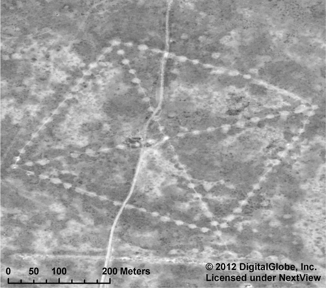
Often called the “Nazca Lines of Kazakhstan,” this cluster of approximately 260 earthworks in the Turgai region of northern Kazakhstan known as the Steppe Geoglyphs includes a variety of geometric shapes, including squares, crosses, circles and a three-pronged swastika-like design. The positive geoglyphs (meaning that their creators used earthen materials, such as dirt, rocks or lumber, to build them up out of the ground) range in size from 295 feet to more than 1,300 feet in length. Dmitriy Dey, a Kazakh economist, made the discovery in 2007 while browsing Google Earth.
There has been some controversy over when they were formed, with some reports estimating the earthworks to be around 8,000 years old, and others pegging them closer to 2,800 years old. Some researchers believe that they’re the work of the Mahandzhar, a nomadic people who once roamed the area. However, scholars are still trying to decipher the geoglyphs’ purpose. One theory is that they were used to track the movement of the sun, but significant excavations of the mounds have not yet been done. Recently NASA provided archeologists with satellite photos of the site, in hopes that these images could shed light on the site's intended purpose.
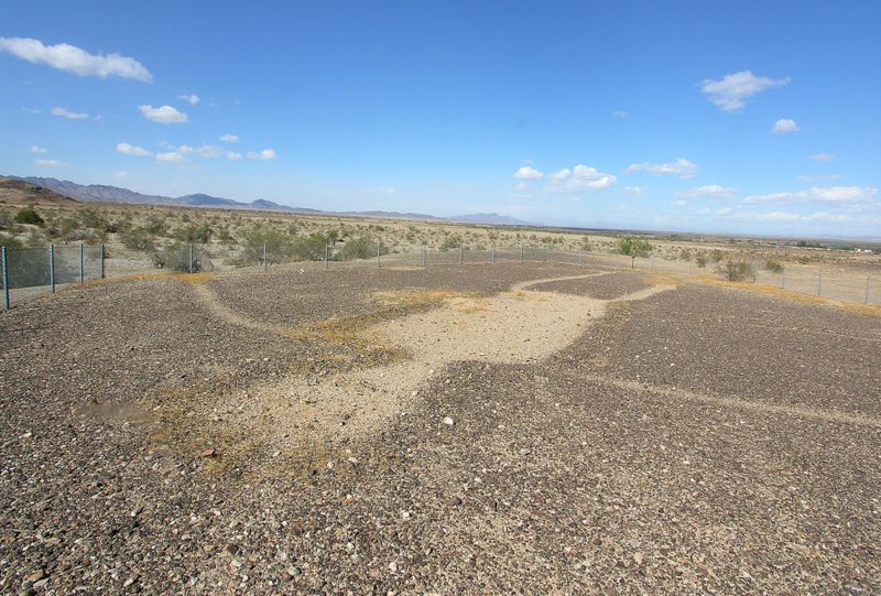
Blythe Intaglios, California
.jpg)
Located several miles west of the California-Arizona border, the Blythe Intaglios or “Blythe Giants” are comprised of six figures, including that of a human being and an animal. The largest of the carvings stretches 167 feet in length while the shortest is 95 feet. The local Mohave (or Mojave) tribe believes that the human figure represents Mustamho, the tribe’s creator, while the animal figure represents Hatakulya, a mountain lion who served as his helper. Perhaps what’s most intriguing is that they’re quite difficult to discern at ground level, since the desert etchings aren’t terribly deep. In fact, a helicopter pilot named George Palmer is credited with discovering them during a flight in 1930. While it’s unclear from archaeological studies when these geoglyphs were created (dates range between 450 and 2,000 years ago), the Mohave maintain that they have been a part of their heritage for centuries.
Paracas Candelabra, Peru
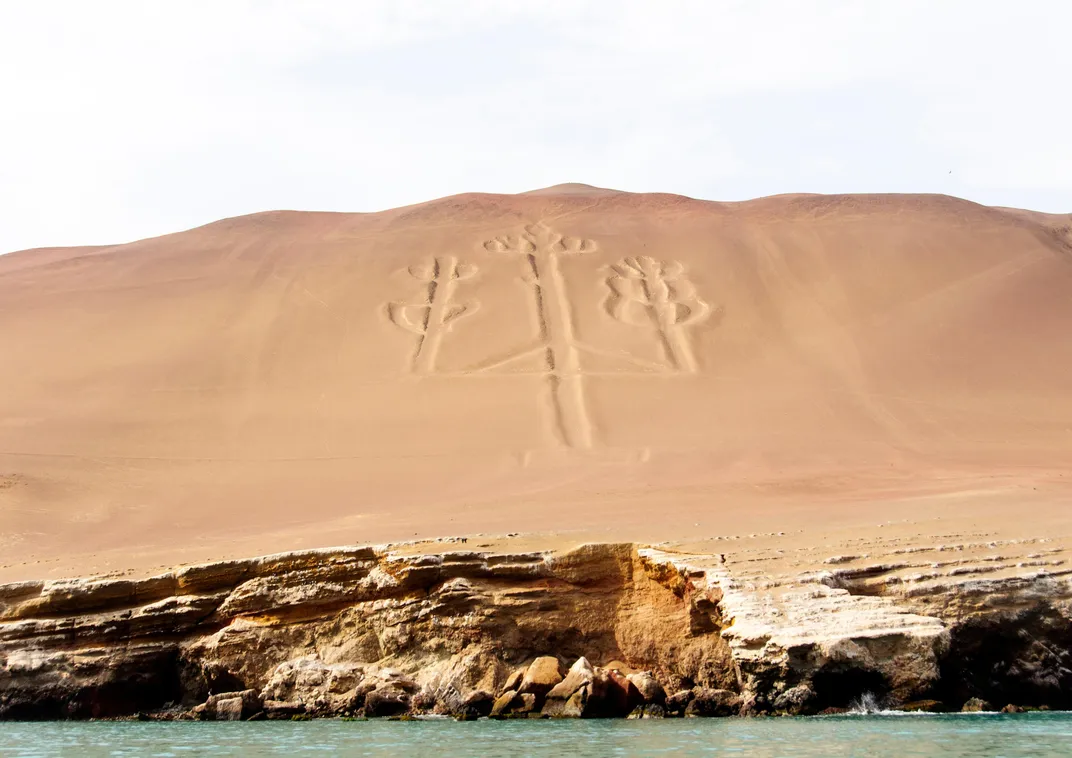
When most people think of Peruvian geoglyphs, images of the Nazca Lines come to mind. However, an equally impressive earthwork sits 116 miles to the northwest and is known as the Paracas Candelabra. Located on the Paracas Peninsula along Pisco Bay, the massive geoglyph roughly resembles a giant candelabra or branched candlestick, stretching 600 feet from top to bottom and carved two feet deep into the face of a hill. Carbon dating of pottery discovered at the site dates the pieces to approximately 200 BC, yet archaeologists have yet to conclude whether that time frame also applies to the candelabra, which can be seen from both the sky and by boat. Unfortunately, it’s anyone’s guess what its original purpose was, since there's no historic documentation in relation to their history. Researchers say it most likely served as a navigational beacon for sailors.
White Horse Hill, England
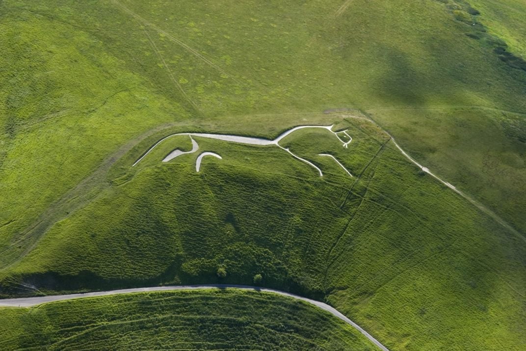
One of the most modern looking geoglyphs in the world also happens to be one of the most ancient. Located on a lush hill in Uffington, a parish in Oxfordshire, England, White Horse Hill dates back to a time between the Bronze and Iron Ages, roughly 1740 and 210 BC, making it the oldest chalk-cut hill figure in Britain. As with other geoglyphs found around the world, archaeologists can only guess as to its original use, which some believe to have been a fertility symbol or perhaps a territory marker. According to aerial imagery, the symbol has evolved over time due to movement of the topsoil, and time has revealed a larger horse-like shape lying beneath what we see most clearly now. Today the site, which is owned and managed by the National Trust, is a popular place for paragliding excursions, hiking and bird watching.
Effigy Mounds, Iowa

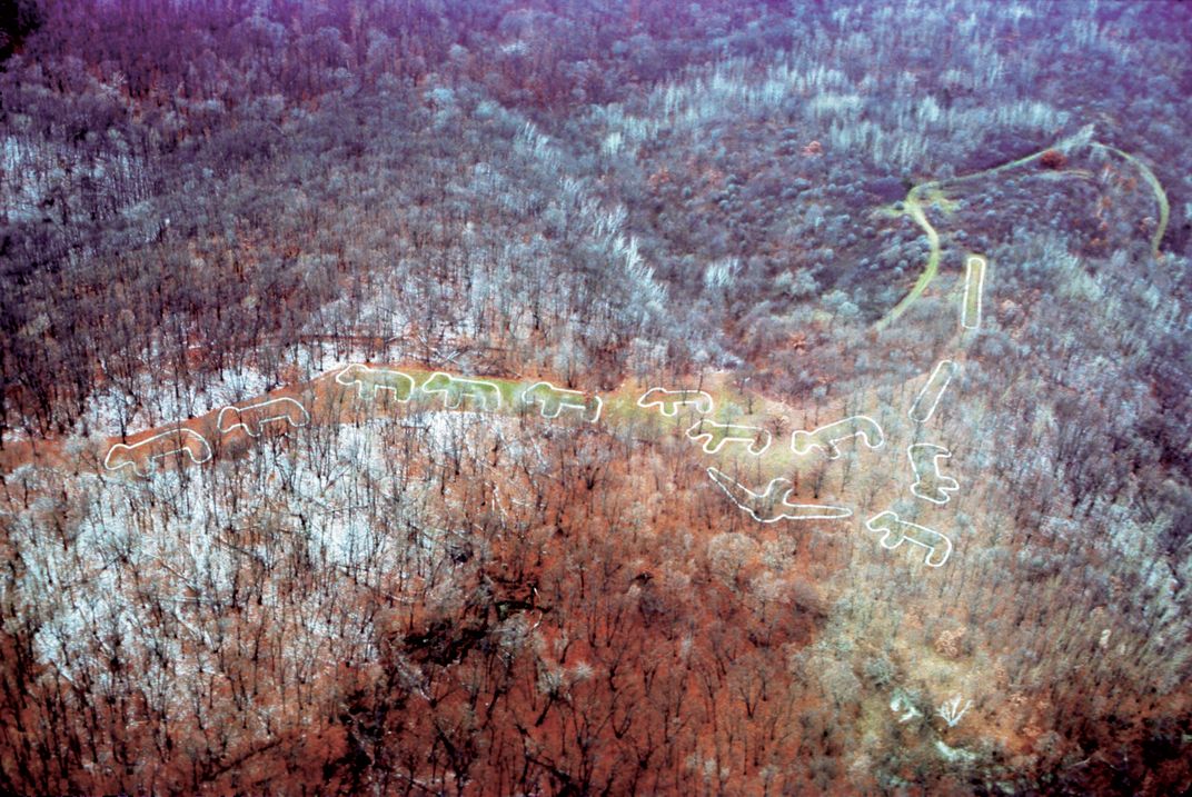

While the creators of many geoglyphs remain a mystery to this day, the Effigy Mounds located along the Iowa-Wisconsin border can be attributed to the Effigy Mound Builders, a group of Native Americans who once inhabited the region. Sometime between 1400 and 750 BC, members of this egalitarian society piled up mounds of earth in the shapes of birds, deer, turtles, bears and panthers, along with less elaborate shapes and structures like cones and rectangles. Archaeologists have found that many of these mounds once served as ceremonial and burial sites, a conclusion that has been confirmed by the builders’ descendants who have heard stories passed down by their elders; however, some historians believe they may also have been used to mark celestial events or territories. Excavations of the effigies have revealed human remains, and today, the location serves as a national monument managed by the National Parks Service.