Day 4: Touring By Helicopter
Secretary Clough visits the driest place on the planet, Ernest Shackleton’s hut, penguins, whales and more on his final day in Antarctica
/https://tf-cmsv2-smithsonianmag-media.s3.amazonaws.com/accounts/headshot/wayne-clough-240.png)
/https://tf-cmsv2-smithsonianmag-media.s3.amazonaws.com/filer/Wayne-Clough-Lake-Hoare-631.jpg)
You won’t find many roads in Antarctica and those you do find don’t go far. If you need to get someplace on land, you’ll be going by air and if where you’re going doesn’t have a runway, you’ll need a helicopter. McMurdo Station keeps a fleet of helicopters operating almost full time during the summer months. They are particularly useful here because scientists are the kind of folks who want to go places that are hard to get to and where hardly anyone else would want to go, such as the Dry Valleys of Antarctica or far out on the ice. The scientists typically set up a camp at remote sites consisting of a few tents and sometimes a lab module—a small prefabricated structure that can be flown in by helicopter—if you can prove you warrant one.
Helicopters deliver the scientific teams to their sites and provide them with supplies that will last for the period of the work, often weeks or a month or two. Field work of necessity is intense, focused on an all-out effort to get as much done as possible in the short summer, record the data and take specimens for subsequent analysis in the more substantial labs found at McMurdo. It takes a special kind of person to make this kind of effort given that the “pay” for the work is essentially only the excitement of discovery.
Today we have the opportunity to visit field sites in one of the McMurdo helicopters, and we have another beautiful day for this trip. There is hardly a cloud in the sky and the temperatures hover around freezing, positively balmy for this clime. You can see forever in these conditions and the view never fails to inspire awe.
At 8 a.m., we arrive at the heliport where helicopters are already taking off for different locations. We are briefed on helicopter safety and given a helmet with a cord to plug into the helicopter’s voice system. We are weighed with all of our gear to make sure our cumulative weight will not create an overload. Fortunately, we pass the test and we board our helicopter. Because there are only five of us (not including the pilot and co-pilot)—Kristina Johnson, Steve Koonin, Tom Peterson, me and Dr. Alex Isern, an National Science Foundation employee program officer in the office of polar programs—we all get window views. Alex proves be adept in helping us understand the ways of the helicopter as well as being knowledgeable about all of the science we will see.
This morning our trip will focus on the famous Dry Valleys of the Antarctic, the driest places on earth. The only other places comparable to them are thought to exist on other planets, such as Mars. The Dry Valleys of Antarctica receive only the barest precipitation, and as best as can be determined, have seen no measurable precipitation for more than 2 million years. That’s a right pert dry spell by anybody’s calculation.
That is not to say that there is no water or moisture in the Dry Valleys because they do have massive valley floor glaciers as well as alpine glaciers that spill down the valley walls attempting to reach the valley floor. The valley glaciers move at a “glacial pace” of truly epic slowness toward the sea, not by virtue of snowfall in the valleys themselves, but because of small annual snowfalls up in the mountain peaks that are the glaciers’ source.
The “hanging glaciers” on the valley walls more often than not cannot ever reach the floor of the valley because the annual snow falls in the mountains that drive them are so small the glacial front reaches an equilibrium point where its ice front sublimates, or passes from solid directly to water vapor, as fast as the front tries to advance. Still, on a few rare warm summer days some of the ice of the valley glaciers and hanging glaciers does melt. Scientists call this melting a “pulse” because it occurs infrequently and for a short period of time. The pulse water flows into lakes that form in the valleys between the fronts of the valley glaciers. The flow into the lakes is so small and so much of the water evaporates during the summer that it gradually creates a salt lake, much like those you would find in a desert area.
As scientists learn more about these lakes they have found that the salinity is stratified with some depths more saline than others. The lakes range in depth from 25 to 40 feet, and are of great interest not only to biologists but also those who expect to find such features on the dry surfaces of planets that do not have as rich an atmosphere as the earth. NASA has even sent a submersible to these lakes to explore them at depth because it is believed if there are extraterrestrial lakes they might look just like those found in the Dry Valleys of Antarctica. Our helicopter lifts off around 9 a.m. and we take a flight path to the northwest across the sea ice of McMurdo Sound with sweeping views of Mount Erebus to the east and the snow-covered mountain ranges that contain the Dry Valleys. As if to emphasize that we are in the Antarctic, a group of large surprisingly rectilinear icebergs lounge at the boundary of sea and sea ice.
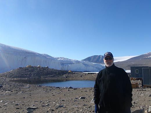
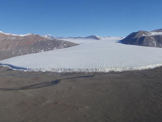
Our first stop takes us up Taylor Valley to Lake Hoare where a research team working with Diana Wall of Colorado State University is studying interactions between climate and other global changes on the abundance, diversity and distribution of soil biota. Looming like a massive white curtain wall across the east side of the valley floor is the 50-foot front of a glacier that has intruded itself just downstream of Lake Hoare after travelling down from a higher valley and making a sharp right turn into Lake Hoare where it appears like an uninvited guest. As we take a moment to look around, we are surprised to come upon the bodies of a penguin and a seal lying at the foot of the glacial front. Amazingly, these creatures had apparently made their way across the vast expanse of the glacier lying in the entrance to Taylor Valley only to fall over the precipice of the front. We are told these animals likely lost their way due to some failure of their natural navigation system and just kept going until their fate was sealed. In this arid and cold climate without the presence of scavengers, bodies mummify and remain for years. The Antarctic does not give mercy to those who make mistakes.
Lake Hoare lies in a valley surrounded by steep walls with exposed, bare rock showing sculpted scars created by the valley glaciers during the last period of glacial advance around 20,000 years ago. The valley walls exhibit faults and magmatic dikes that cut across the beds. These rocks are much older than the Antarctic continent itself, having been part of the ancient supercontinent Gondwana before it separated into today’s many parts. Standing in this spot you can see direct evidence for the power of nature and sense its patient processes: Tectonic plate movements that move continents and make mountains where none existed, winds that scour rocks and pulverize them, glaciers that silently move and strip bare rock walls, gravity that brings down big boulders so that the bounce like toys into the glaciers below, and freezing water that expands and cracks even the hardest rock. Humans have a difficult time appreciating all of this even though it is massive and constant because nature works on such a long time scale. We live on average 75 years and our species only goes back about 200,000 years, a blink in the eye of nature. Yet we are beginning to become something of a geologic force ourselves, because the cumulative impact of 7 billion of us on the planet is having an effect.
The camp at Lake Hoare consists of a few buildings, mainly housing laboratory equipment, and a series of individual tents for the scientists, set apart from each other to provide some degree of privacy.
This camp has more than the norm in the way of facilities because it is a base for other camps up the valleys. Its operations are run by Sharon (Rae) Spain, a contractor for the NSF Polar Program, who is famed for her ability to make things work in this remote and difficult environment. Rae is so outgoing and enthusiastic it is immediately apparent that she loves the life she lives here.
In fact, every member of Diana’s team is enthusiastic about the work they are doing and each brings different skill sets to the project at hand. I am pleased to meet Dr. Fred Ogden from the University of Wyoming, a hydrologist studying water and moisture movement, who is also a research associate at the Smithsonian Tropical Research Institute in Panama. Antarctica is a long way from the tropics, and I ask about his research. He is studying water flow to develop better hydrologic models for forecasting as part of the Agua Salud project. Shallow subsurface water flow is an important part of the Panama Canal watershed and since all subsurface water flow is shallow in Antarctica because of the permafrost, it is actually simpler to study.

Lake Hoare itself is not a large lake, but is significant and saline. The beach is composed of a dark soil with inclusions of rocks that have fallen into it from the valley walls. There are octagonal patterns in the soil that mimic those seen in dry lake beds in the desert. Talus deposits of soil and rock (or scree, broken bits of rock) rise from the beach towards the valley walls. Where these deposits have a smooth surface, they are often eroded with V-shaped channels that appear to have been created by water. Beneath them as they lead to the lake, the soil appears darker.
The science team helps us understand what we see. Fred and Joe Levy from Portland State University explain that the V-shaped features we see in the talus slopes are indeed water induced, forming during an especially warm day as a pulse of melt water from the glaciers above flows in small streams downward toward the lake. The dark areas on the soil are created by the melt water but reflect small flows that continue from above but remain underground. As to the octagonal features, these develop with freezing and thawing cycles in the permafrost, much as are seen in permafrost in the Arctic.
So, there is water here in the soil but it is intermittent and comes very rarely. How is life sustained in the frigid, arid environment of the Dry Valleys? This is another matter of study for Diana and her team. They look for a creature known as a nematode that is all of a millimeter long and resides in the soil. A nematode may be small, but it is mighty in its evolved ability to survive in a hostile environment. This tiny creature understands that it lives two lives, one for the long dry times and one for the fleeting times when a small drop of moisture might come its way. During dry times it can give up almost all of its body moisture and simply stop normal body activities. It can lie patiently dormant for tens of years, but give it a bit of moisture and it will absorb it and come back to life, making the most of the moment. Why should any of this be of interest to us? First, as noted, these dry valleys may mimic similar environments on moisture-deprived Mars and other planets. We can learn how to look for life on other planets by studying these unusual creatures. Second, with climate change, creatures like the nematode may disappear, so we need to do all we can to understand them now. We can best deal with the effects of climate change if we understand what it does in all of its ramifications for the earth.
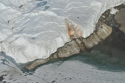
Although we could have stayed all day to hear more about the research at Lake Hoare, our schedule dictates we have to move on and we lift off to head further up Taylor Valley. However, shortly after lift-off we are notified that winds at higher elevations are reaching dangerous levels for helicopter travel—and indeed, the helicopter is already pitching and yawing. We reach the site of Blood Falls, a glacial front at Lake Bonney in the Taylor Valley. The ice contains algae that create an unusual red color on the front of the glacier. It is believed this algae is related to those that cause red algal blooms along coastal areas from time to time.
Alex and our pilot agree that we should return to safer air and we turn back down the valley and land at Lake Fryxell where Dr. John Gillies of the Desert Research Institute in Reno, Nev., and his colleague William Nickling are studying the aeolian—or wind-driven—processes that act on the valley soils and rocks. We are shown a rock with a split personality: One side has faced the winds that roar down the valley in the winter months while the other side was protected. Where it was exposed to the winds the surface is smooth and pitted with very tiny indentations. The protected side shows the rough rock surface one would expect: a graphic demonstration of the power of wind erosion.
Our next stop is for lunch at Marble Point, a site on the west side of McMurdo Sound that serves as a fuel depot for the helicopter fleet. It also is known for its gregarious cook, Karen Moore, who has prepared her famous chili for us. Maybe it is just the beautiful setting, the cold weather, or the excitement of being here, but this chili is maybe the best I have ever had. Topped off with cornbread fresh from the oven and it is a feast fit for a king. We can’t stay long, but we owe a debt of gratitude to Karen for making this stop both special and satisfying.
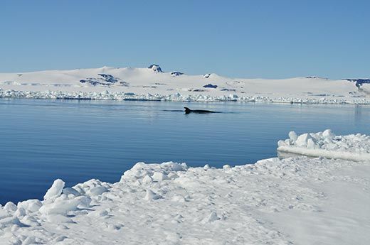
We board the helicopter and fly along the edge of the shipping channel that has recently been cut in the sea ice by the Swedish icebreaker Oden in preparation for the arrival of the annual fuel tanker and supply ship. The wind has disappeared and the air is calm. To the west, Mount Erebus stands in all its glory. Down below is the deep, clear water of McMurdo Sound. Suddenly, whales! Minke whales take advantage of the ship channel just as a car uses a freeway by cruising along the edge of the ice in pods of two or three. They glide through the water, occasionally coming to the surface for a blow and a breath of air before resuming their course.
Our pilot says he can land on the ice where it is around 30 inches thick if we want a closer look. Needless to say, we do. He lands about 100 yards back from the ship channel and the co-pilot uses an ice auger to measure the thickness of the ice. It checks out and we proceed on foot toward the channel; Alex warns us to look for cracks that form near the edge and to make sure that we stay on the main ice sheet. Waiting with anticipation, we are thrilled as several of the whales rise to the surface, blowing air and water vapor before they head down again. You have to be quick to get a picture since you never know where they will surface next, but we get lucky more than once.
The whales are the very essence of grace and seem not the least concerned by our presence. After our first delighted exclamations each time a whale breaches the surface, we grow quieter. Alex notices it first: A pinging noise followed by some low vocalizations. The whales are moving through the water below the ice we are standing on and using sonar to locate fish. Alex tells us Minke whales do not hunt creatures on the top of the ice as Orcas do at times, so we feel reassured the pinging is not about locating us as prey.
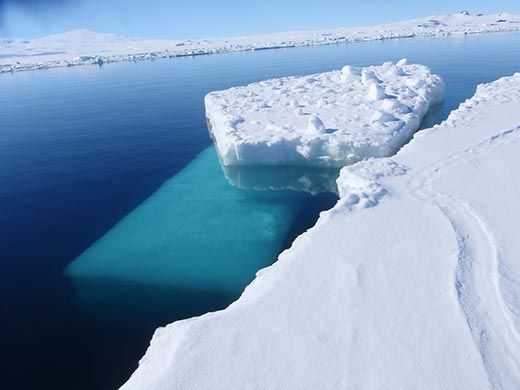
It really doesn’t get much better than this. We are standing on the sea ice of McMurdo Sound on a beautiful sunny day with no one else in sight. The quiet is so profound it seems as if we are in a vacuum. The dark surface of the water is a mirror, reflecting the shimmering mountains fronted by Mount Erebus. A rectilinear block of ice that broke off when the ice breaker passed through floats near the edge of the channel. Through the clear dark water its underwater mass gleams as an emerald green jewel, seemingly unconnected to the body of the gleaming white mini-iceberg above. And, under us and beside us are the graceful whales sliding through the water, allowing us to vicariously join them through their vocalizations. We are mesmerized momentarily by the seductive beauty of it all.
The spell is broken as we are called to board the helicopter for our next and final stop. The schedule must hold for we have an event this evening we must attend. This last leg of our helicopter tour will take us back in time and at the same time allow us to see yet another of the remarkable creatures that populate the regions of the sea ice.
Our destination is Cape Royd on Ross Island, the site of Sir Ernest Shackleton’s base as he prepared for his march to the Pole in 1907 as leader of the Nimrod Expedition. The hut he and his companions built at Cape Royd, along with 33 other sites from the “historic era” of Antarctic exploration, is protected by the Antarctic Heritage Trust, a New Zealand non-profit. The hut is a rough structure with an enclosure that was used when the explorers considered using Siberian ponies to help pull the sleds. The food for the ponies is still there, hay and oats, spilling out from the bins. Nearby are crates of foodstuffs and other supplies for the men that were left behind when the expedition locked up and left in 1909.
Inside, the hut is permeated by a human presence. Sweaters, pants and socks used by Shackleton and his men lie on the bunks. Canned goods, writing paper, cured hams and candles are stored neatly on shelves and in spare rooms. Down in a root cellar the curators recently found a case of Scotch whisky was Irish) that is thought to be still drinkable. The expedition used an ingenious gas lighting system to illuminate the hut and make it as liveable as possible. The names of the expedition members are inscribed above the bunks they slept; and above one, Ernest Shackleton has written his name in his own handwriting. In the quiet, you can almost hear them, men who were about to undertake an expedition that would challenge them to the core. I feel honored to be able to sign the guest book as a measure of paying respects to these brave souls.
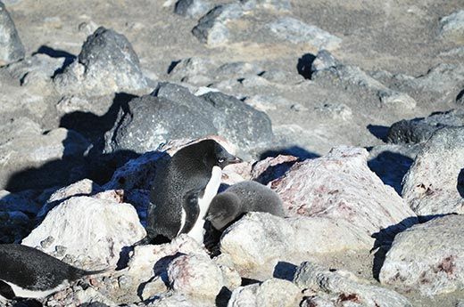
Shackleton’s hut is located a short walk from an Adelie penguin rookery that is protected as a natural wildlife area. The setting for the rookery is a rocky promontory rising from the dark water of McMurdo Sound that is lashed by cold winds. Several hundred Adelies and their gray down-covered chicks call this spot home. Waves crash against the rocky outcrops and white blocks of ice wallow and roll in the shallows. Adelies hop from one block to another and enjoy the action as the blocks are roiled by the water.
For the Adelie colony this point would seem to be a protected place to raise chicks, but success in survival also comes down to access to food. Unfortunately, researchers studying the colony have found its numbers declining. The reasons for this are not completely understood, but there are signs that herring, a major source of much of the Adelies’ diet, are moving to new locations, possibly as a result of global warming. Penguin colonies in many areas in the Antarctic are under pressure as their food sources abandon their old haunts and depart to other parts of the ocean. Looking out over this place of rough beauty, I am struck by the fragility of the balance of life in the Antarctic and more firmly convinced than ever of the importance of the research done here to understand how best to conserve the diversity of this part of the planet.
We lift off from Cape Royd considering the contrast of Shackelton’s Hut juxtaposed against the penguin rookery. Antarctica is the last continent on earth where man’s first dwellings still stand but only because humans have never been a part of the ancient cycles of life here. We fly back to McMurdo for a special celebration that is fitting in view of what we have just seen. At 5 p.m. we join a contingent of New Zealanders from Scott Base to inaugurate the operation of three windmills that will supply green energy to Scott Base and McMurdo Station and help reduce the reliance on carbon-based fuels that have to be brought in on ships through dangerous waters. The Kiwis invite us over to Scott Base for a wonderful reception and dinner to close out a most fulfilling day.
As the day ends, I realize that tomorrow I will leave Antarctica and start the long trip back. The morning arrives only too early and the McMurdo team takes the few hours left to show us around the logistics operations for the station. The support staff and facilities are as remarkable as the scientists who are here to help understand this unique continent. The entire station exists to serve about 125 science projects and the people who are here to conduct them. The logistics are daunting: Everything must be shipped in and everything that is not consumed must be shipped out to keep the environment pristine. As we look out over the port we see the annual fuel ship arriving and the supply ship will not be far behind. As soon as the supply ship is emptied, it will be filled with waste to be sent back for proper disposal.
We pack up and are ferried out to Pegasus Airport. Our C17 lifts off from the ice sheet in gleaming sunshine and I feel fortunate to have had this second chance to see this remarkable continent. I am also proud to be a member of the Smithsonian family and of having had a chance appreciate the Institution’s long involvement in helping to understand the Antarctic and its future.
/https://tf-cmsv2-smithsonianmag-media.s3.amazonaws.com/accounts/headshot/wayne-clough-240.png)