Watch Drought Dry Up America’s Groundwater
A drought this year affected large parts of the United States, including a lot of agricultural land
It has been a dry year for most of the United States, and, in the animation above, you can see how the groundwater levels in the United States have been affected by the drought that affects large parts of the country. The animation starts in 2002 and goes through a decade of changes, so watch carefully for the last few seconds to get a good idea of what’s going on now.
Scientists created the maps by using the Gravity Recovery and Climate Experiment, or GRACE, a set-up that consists of two satellites that measure the Earth’s gravity field. Gravity is related to mass, and water reservoirs (both surface and groundwater) have enough mass to affect the gravitational field of the earth.
The effect is very small, but significant enough that GRACE can pick up on the changes as water dries up (or rains down). The instrument is sensitive enough to pick up and differentiate between moisture in less than an inch of soil (the surface zone), moisture in the ground down to 39 inches (the root zone) and water in the aquifers below that.
The image from NASA, below, shows the differences between the three. Look at Texas, where the soil moisture is doing ok, but the groundwater is devastated. The state might have had some rain recently, but not enough to make up for the serious problems with groundwater.
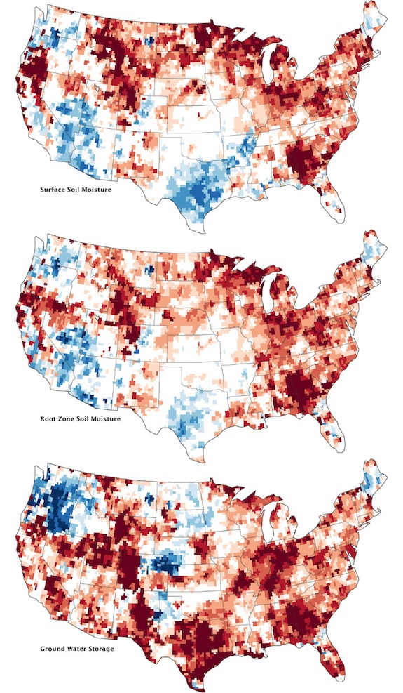
Maps by Chris Poulsen, National Drought Mitigation Center at the University of Nebraska-Lincoln, based on data from Matt Rodell, NASA Goddard Space Flight Center, and the GRACE science team.
More from Smithsonian.com:
Scene From A Drought
U.S. Faces Worst Drought Since 1956
70 Percent of Illinois Is In A Drought (And It’s Better Off Than Indiana)