Sea Level Rising Three Times Faster Than Average on Northeast US Coast

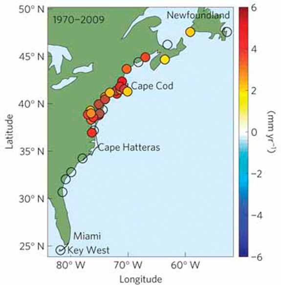
Tide gauge measurements showing the 1970-2009 rate of sea level rise (in millimeters per year) compared against the global average. Photo: Nature Climate Change
A study lead by United States Geological Survey scientist Asbury Sallenger found that over the past 20 years the ocean height has gone up faster along the coast north of Cape Hateras, North Carolina, than to the south. According to Nature,
In absolute figures, sea levels on this stretch of coast have climbed by between 2 and 3.7 millimetres per year since 1980, whereas the global increase over the same period was 0.6–1.0 millimetres per year.
The rapid acceleration, not seen before on the Pacific or Gulf coasts of the US, may be the result of the slowing of the vast currents flowing in the Altantic, said Sallenger. These currents are driven by cold dense water sinking in the Arctic, but the warming of the oceans and the flood of less dense freshwater into the Arctic from Greenland’s melting glaciers means the water sinks less quickly. That means a “slope” from the fastest-moving water in the mid-Atlantic down to the US east coast relaxes, pushing up sea level on the coast.
Sallenger and his team saw the ramped-up sea level rise after combing through and analyzing tide gauge records. Though scientists seem confident in the observed rise, as Science News reports, they don’t all agree on the cause.
Whatever the mechanism driving the ocean to climb, climate change news mega-site ClimateCentral.org has a handy tool to visualize what varying rates of sea level rise could mean for coastal American communities.
More from Smithsonian.com:
/https://tf-cmsv2-smithsonianmag-media.s3.amazonaws.com/accounts/headshot/smartnews-colin-schultz-240.jpg)
/https://tf-cmsv2-smithsonianmag-media.s3.amazonaws.com/accounts/headshot/smartnews-colin-schultz-240.jpg)