Say Goodbye to a Historic El Niño and Hello to La Niña
Conditions are looking ripe for the cooler climate pattern to take over in the Pacific
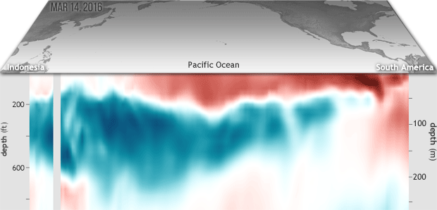
/https://tf-cmsv2-smithsonianmag-media.s3.amazonaws.com/filer/74/c6/74c67342-c9c3-44b6-8ec4-c76141efbcb9/subsurftemp_2016mar14-may3_620.gif)
The grip of one of the strongest El Niños in recorded history is loosening, and in its place it appears that the cool flipside, La Niña, is arriving, writes Dennis Mersereau for Mental Floss.
Both phenomena are part of the El Niño-Southern Oscillation, ENSO, a natural climate variation that swings between warm and rainy conditions (El Niño) in the central-eastern Pacific and cooler, drier conditions (La Niña). The long tongue of slightly-warmer-than-average surface water that makes up El Niño has been weakening and beneath the surface, "a deep pool of cool water has been sliding slowly eastward for the past couple of months," writes Rebecca Lindsey for Climate.gov, from the National Oceanic and Atmospheric Association (NOAA).
If water temperatures persist more than 0.5 degrees Celsius below average, then La Niña has arrived. There's a 75 percent chance that will happen by this fall, writes Emily Becker for NOAA's ENSO blog. For now, global weather patterns are still under the sway of El Niño, technically, but the trend is toward more neutral conditions, she explains. If trends continue, El Niño should kick it at the end of the summer.
The water temperatures and pressure anomalies that herald these patterns might center over the central-eastern Pacific, but the effects ripple across the globe, changing precipitation and temperature patterns in many regions. In North America, the winters are usually milder during an El Niño and the West coast, southern U.S. and southeast see more rainy days.
When La Niña arrives, the U.S. Southwest, central and southern Rockies, the Great Plains and Florida usually have drier weather. Winters under La Niña are likely to be colder in the Northwest, northern California, northern Intermountain West and north-central states. However, although experts have noticed those trends, they have trouble predicting exactly how any one El Niño or La Niña will play out.
"[As] still-parched Californians found out this year, each event is different, and not all of them affect the weather as we would expect," writes Mersereau.
Experts get some idea about how the pattern affects global weather and for how long by looking at past events. Becker writes that there are 14 La Niñas on record:
Of those 14 La Niñas, nine immediately followed El Niño years. Two occurred two years after an El Niño, with a neutral year intervening. Two were the second year of a “double dip” La Niña, where sea surface temperatures briefly returned to neutral during the summer before heading back into La Niña territory (1974/75 and 2011/12). The remaining one starts the records off in 1950.
La Niñas also tend to last longer than El Niños. After the unusually strong 1997/98 El Niño, La Niña lasted for 33 months, spanning three winters.
Still, even with a potential La Niña on the way, 2016 is on track to become the hottest year in recorded history, beating out 2015, Maddie Stone notes for Gizmodo. April 2016 was the 12th consecutive warmest month on record. She explains that even with the powerful influences of oscillating climate anomalies, "humans now control the master switch when it comes to our planet’s thermostat."