Shore Thing
In the new Boston Harbor Islands national park area, city dwellers can escape the madding crowds


Doree cox and katharine wolfe sport bedrolls, water bottles, and backpacks bulging with MREs (Meals Ready to Eat) ordered from a military catalog. For these wilderness hikers, Maine is old hat, the Adirondacks a walk in the park. But roughing it in the middle of BostonHarbor? Now you’re talking.
“We had the whole island to ourselves,” said Cox, 77, after camping for two nights on 62-acre Lovell’s Island. “We made a fire on the beach, ate dinner and watched the lights of Boston go on.” Their one regret? Not being able to harvest the wild blackberries growing everywhere in the tangled thickets. “The berries won’t be ripe for a few weeks,” says Wolfe, 64.
“We watched seagulls drop mussels on the rocks, to break open the shells,” says Cox. “The planes from LoganAirport took off right over the campsite every 70 seconds, so there was a bit of a roar, but it was an absolutely fantastic experience.”
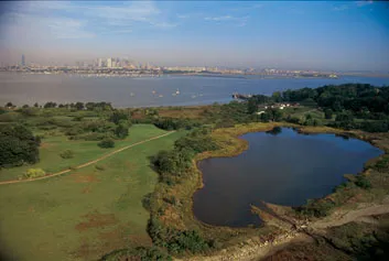
For those who make the effort to reach them, Boston’s harbor islands offer scenic beauty and history. Yet they lie virtually unnoticed at the doorstep of the nation’s seventh-largest metropolitan area.
To transform the neglected offshore wilderness into a center- stage attraction, the federal government created one of the nation’s most unusual national parks in 1996. The 1,600 acres of land making up the Boston Harbor Islands National Park Area encompasses some 30 islands and several peninsulas, all within a 12-mile radius of downtown. They range from 248-acre World’s End peninsula, whose carriage paths were laid out by Frederick Law Olmsted, to tiny outcrops like ButtonIsland, accessible only by boat. The National Park Service, engaged in an innovative approach to stewardship, manages the park in partnership with the city of Boston, state agencies and a pair of private nonprofit groups.
More than 100,000 ferry passengers visit annually, a figure that hasn’t budged from the days when it was just a state park. Guidebooks to Boston barely mention the park’s existence. One reason is its lack of amenities: the islands share a single snack bar and just one rest room with running water (both on George’s Island). Park superintendent George Price thinks the numbers will climb after the park’s first full-fledged visitor’s center opens on SpectacleIsland, possibly next summer. “It’s one island you can see from a lot of Boston neighborhoods,” he says. Price hopes that new attractions, from outdoor concerts to food concessions, will eventually draw half a million visitors each year.
The new park doesn’t teem with endangered species or boast pristine wilderness enclaves. Its attractions are tied to a dramatic history at the margins of society, as the island names suggest: Hangman, Bumpkin, Ragged, Shag Rocks, The Graves.
“For centuries, the harbor islands have been the place where Boston put what it didn’t want to see or deal with, from prisoners to the mentally ill to horse-rendering facilities,” says former congressman Gerry Studds, who championed the creation of the park in the mid-1990s. Since before the Boston Tea Party, everything from bare-knuckled boxing to prostitution flourished here largely out of sight of both proper and not-so-proper Bostonians. “Ironically, in a city that from its beginnings has made its livelihood from the sea,” says Studds, “most people today are unaware that they have a harbor full of islands.”
Fifty years ago, SpectacleIsland, closest to the inner harbor, was a city dump oozing toxic waste into the surrounding waters and smoldering with underground fires from burning trash. FortWarren, a sprawling mid-19th-century redoubt on George’s Island, was eyed as a radioactive-waste depot. Thanks to a public outcry, and a 13-year campaign led by local historian Edward Rowe Snow, the islands became a state park in 1970. Though nominally protected, they continued to languish into the 1990s, short of funds, attention and respect.
Part of the problem was pollution; until ten years ago, Boston and 43 other towns were pouring raw sewage into the harbor. Today, after massive clean-up efforts, beaches have reopened, clammers are digging again and harbor seals and even porpoises are back. Not long ago a juvenile humpback whale was spotted frolicking a few hundred yards off DeerIsland, site of Boston’s gleaming new 150-acre, $3.8 billion waste-treatment facility.
If DeerIsland houses a high-tech complex, ThompsonIsland, with its oak and birch forests and salt marshes, is a beckoning retreat. In private hands almost continuously since 1626, when Scotsman David Thompson built a trading post that was likely Boston’s first permanent structure, the island is now owned by the Thompson Island Outward Bound Education Center, a foundation that operates a school for boys on it and hosts Outward Bound courses for all ages. The island is open for public tours on Saturdays.
Thompson has been home to institutions of learning since 1833, when a school for indigent boys was founded “for the reformation of boys who . . . are in danger of becoming vicious or useless members of society.” The reform-school taint is gone, but the emphasis on urban youth remains. Willauer is the island’s academically challenging school for 50 adolescent boys, most of whom ride the ferry back and forth every day to its hilltop clearing campus.
Some of the Willauer boys had never visited a national park before—or even ridden in a boat. “The cool thing about this island is there’s so many birds,” says eighth grader Anthony Estremera, 14, inspecting the birdhouses he and his classmates placed in a meadow the day before. Now he shouts, “That’s my box! There’s a bird in it!” Not just any bird, it turns out, but an Eastern bluebird, its numbers slowly recovering from Maine to Mexico. “I can’t believe a bird is already living there.” At home in Dorchester, his inner-city Boston neighborhood, threatened species are hardly an everyday sight.
At extreme low tide, a gravel spit connects Thompson to the mainland at Quincy. The depth of BostonHarbor is rarely more than 50 feet; many areas are shallower than the deep end of a swimming pool. Not long ago (geologically speaking) most of it was dry land. Many of the islands and much of the Massachusetts coast are mounds of glacial till, or drumlins, deposited by ice age glaciers during the past 100,000 years. As recently as 6,000 years ago, the islands were hills set amid grassy and forested lowlands. As glaciers worldwide melted over the next thousand years, sea levels rose dramatically. The lowlands flooded, leaving one of the world’s few drowned drumlin fields.
In the rich estuaries around the harbor, Indians caught fish and gathered shellfish. In the uplands, they hunted deer and grew corn, beans and squash. Archaeologists have turned up everything from drill bits and stone weights, used to anchor fishing nets, to beads made of bone, cunningly hammered and wrapped in copper loops. In the 1600s, however, English settlers displaced the native inhabitants by treaty and by force. After a bitter conflict known as King Philip’s War broke out between colonists and Indians in the 1670s, settlers turned on all Native Americans, including peaceful Christianized Indians.
“They were rounded up under chain and musket, deported to DeerIsland with nothing but blankets, and left there to die,” says Mildred McCowan, 61, a national park adviser who traces her lineage to internment survivors. As many as 3,000 Indians may have succumbed to starvation, exposure and disease. “It was a death camp,” McCowan says. Memorials are planned to commemorate these Native Americans, as well as the more than 700 Irish immigrants who died of smallpox and yellow fever when the island was a quarantine station in the mid-1800s.
Indeed, much of the harbor islands’ past bears a grim undercurrent. For centuries, their shores have been graveyards for foundering ships and drowned sailors. Hostilities have shaped the islands’ history since the Revolution, as evidenced by the remains of many old forts. FortAndrews, on Peddock’s Island, was built in 1900, after the Spanish-American War, to guard the port of Boston. Today it lies in ruins.
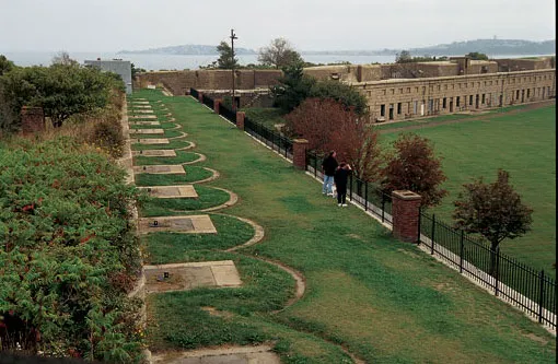
FortWarren, which dominates George’s Island and is reachable by ferry departing from Boston’s LongWharf, is the national park’s crown jewel. In the 1830s, when former West Point superintendent Sylvanus Thayer designed the bastion, it was considered state of the art. Today, with its ten-foot-thick stone walls, hand-cut granite spiral staircases and ghostly Corridor of Dungeons, it has the air of a medieval relic.
In a moist-walled granite room that once housed Confederate prisoners, volunteer tour guide Charlie Boyer, 78, a whitehaired former deputy sheriff with a heavy Boston accent, recounts the legend of the Lady in Black, the wife of a Southern prisoner. As the story goes, she stole ashore here with a gun in 1862 and was hanged as a spy at what is now the picnic grounds. “She’s been seen here 28 times since,” Boyer says solemnly.
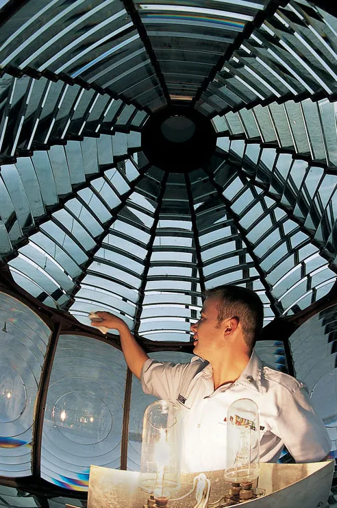
Two miles to the east, the harbor’s most recognizable landmark, Boston Light, rises on the four-acre rock known as Little Brewster. In operation since 1716, the light is the oldest and the last fully manned Coast Guard lighthouse in the country. After only a year on the job, the first light keeper and his two daughters drowned in 1718, rowing to land in a gale. An enterprising young Boston resident, Benjamin Franklin, quickly wrote a poem about the tragedy and peddled it around town, although, he would confess in his autobiography, the verse was “wretched stuff.” During the War of 1812, a keeper and his wife had a firsthand view of the battle of the American warship Chesapeakeand the British frigate Shannon, but they were beyond earshot of the American commander, Capt. James Lawrence, who implored his men: “Don’t give up the ship!” (or words to that effect).
Sharing light-keeping duties today are Coast Guard petty officers Pedro Gonzalez, age 28, Ben O’Brien, 25, and Carlos august 2003 Smithsonian Colón, 27, who enjoy satellite TV, an Internet connection, and Sam and Cyrus, the two lighthouse dogs. Colón, a native of Puerto Rico, appreciates even the winter nights here. “When there’s a storm and you see the light rotating through the snow, it’s beautiful.” The park runs boat trips to the light four days a week in summer, weather permitting, at $30 a head.
Twelve months a year, anyone who doesn’t mind getting soaked to the skin and is willing to grip an oar can get to the islands courtesy of the HullLifesavingMuseum, located in the coastal town of Hull. Early one Saturday morning, a team of six rowers sets out in a 32-foot gig, hauling on splintered wooden oars. This was a treacherous place, says the museum’s Ed McCabe, 54, “if you were sailing a square-rigger into BostonHarbor.” He is describing Brewster Spit, a gravel shoal extending west from the island of Great Brewster for nearly a mile. At high tide, it’s invisible. Between tides, it looks like a foamy rupture in the harbor.
After an hour’s rowing, McCabe and crew fetch up on CalfIsland. Here actress Julia Arthur, known as the Sarah Bernhardt of America, summered during the 1890s. All that’s left of the ballroom in her mansion is a mosaic, made of beach stones, over the fireplace. Vandalism, even more than the elements, is the culprit: boaters have come ashore here for generations.
For now, Calf and at least a dozen other islands, including tiny 11-acre Rainsford, remain visit-at-your-own-risk destinations. Rainsford was a quarantine station for 18th-century immigrants; it housed a smallpox hospital in the 19th and a reform school in the 20th. “I’ve heard my great-uncle Jack was one of the bad boys out here between 1900 and 1910,” says Ellen Berkland, Boston’s city archaeologist, on hand with archaeologist Stefan Claesson and historian Elizabeth Carella for a fact-finding dig. “People are amazed how much of the past resides here,” says Carella.
Some of the unmarked graves of Rainsford’s cemetery, overgrown with lilacs and lilies gone wild, date to the early 1700s. Beyond the cemetery lie the ruins of the smallpox hospital, once a stately granite edifice. Abit farther on, a smooth slate outcrop jutting above a cove contains scores of names and dates from the early 1800s, some hastily scratched into the surface, others bordered and serifed as elegantly as script incised on a headstone.
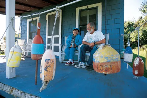
Only a short distance away, on Peddock’s Island, a 4,100- year-old skeleton—the oldest human remains found in New England—was unearthed in the late 1960s by a woman digging in her garden. That Peddock’s has a residential community at all is one of the park’s peculiarities. Once a fishing village of Azorean immigrants, the settlement is now a dwindling summer colony. Lawns and flower gardens are well tended, but most of the 32 cottages are spartan. It’s undoubtedly the only Bostonarea neighborhood with functioning outhouses.
Claire Hale, 68, has summered here since she was a child. “In 1939, my father and mother bought a cottage for ten dollars,” she says, seated in a rocker on her front porch next to a car battery she uses to power her TV. She and her husband, Bill, pump their own well water and read by the light of kerosene lamps.
The Hales have life tenure; after they die, the park will probably take over their neat two-story cottage. “We’re trying to turn one of the cottages into a museum,” she says. “This island has real history, and people need to know about it.”
A short walk from the Hales’ cottage lies Prince’s Head, a sliver of promontory apparently never inhabited. In the 1940s, an armament works on nearby NutIsland used Prince’s Head for target practice, but pounding waves have done more damage than artillery shells. The tiny ridge is shrinking fast. “It’s going to be gone in our lifetimes, easily,” says Peter Rosen, a coastal geologist. In fact, he adds, all the harbor islands are eroding.
So if you’re considering a visit, don’t dally. “In a thousand years, there will be no harbor islands,” Rosen says. Then he corrects himself. “In a thousand years, Beacon Hill, Bunker Hill, the other hills of Boston—those will be the new harbor islands.”