Picture of the Week—Ancient Altinum
/https://tf-cmsv2-smithsonianmag-media.s3.amazonaws.com/filer/20110520102248altinumimage.jpg)
Before Venice, there was Altinum. During its heydey in the first century A.D., Altinum was a great Roman coastal city, home to as many as 20,000 people, where traders would come to do business from across the Mediterranean. But in the fifth to seventh centuries, the people left Altinum, driven by barbarian invasions to the islands that would eventually become Venice. Stones and bricks from Altinum would be used in building Venice, but Altinum would eventually become overgrown. Some parts became submerged beneath the Lagoon of Venice and others are now covered with farm fields.
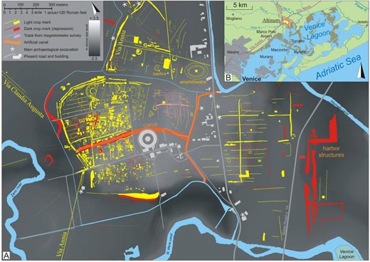
A drought in 2007 presented a unique opportunity to learn more about the site without having to dig. A group of Italian scientists took the near-infrared aerial photograph above (their study appears in the July 31 issue of Science). Because the landscape was so dry, the scientists could "see" what was buried beneath the crops reflected in the health of the plants. Stones, bricks and compacted soil appear in lighter blue, and depressed features like pits and canals show up in the darker red. With the image, the researchers built a map of the city (below). With this map, they were able to confirm that the city had been partially surrounded by water, just as the ancient Greek geographer Strabo had described in the first century B.C.
Images copyright Science/AAAS. Check out the entire collection of Pictures of the Week on our Facebook fan page.
/https://tf-cmsv2-smithsonianmag-media.s3.amazonaws.com/accounts/headshot/Sarah-Zielinski-240.jpg)

/https://tf-cmsv2-smithsonianmag-media.s3.amazonaws.com/accounts/headshot/Sarah-Zielinski-240.jpg)