The Mad Dash to Figure Out the Fate of Peatlands
As the planet’s peat swamps come under threat, the destiny of their stored carbon remains a mystery
/https://tf-cmsv2-smithsonianmag-media.s3.amazonaws.com/accounts/headshot/Michelle-Donahue.jpg)
/https://tf-cmsv2-smithsonianmag-media.s3.amazonaws.com/filer/e7/5b/e75b8b0e-392f-4f00-b7df-f9a7c81724b7/oil_palm_harvest.jpg)
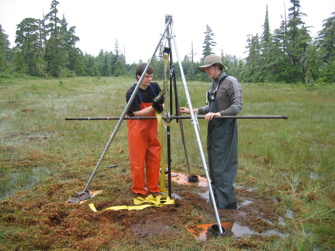
With every step he took, Jon Nichols’ boots squelched on the ground beneath him. He recorded his surroundings on a grainy cellphone video, and despite the damp, gray day, Alaska’s Chugach Mountains still provided a stunning backdrop to the tall spruces and low-growing scruff at his feet. He and two colleagues wound their way along the edges of Corser Bog, a damp patch of earth 10 miles due east of Cordova, Alaska, a lonely dot on the map not far from where the Exxon-Valdez oil tanker ran aground in 1989.
“On we trudge,” Nichols said, “through the muskeg meander.”
Muskeg is another name for the peat bogs he studies, and Nichols was slogging through the muck that day in 2010 in pursuit of core samples to learn how the 12,000-year-old bog formed. As a paleoecologist and peat researcher with Columbia University’s Lamont-Doherty Earth Observatory, Nichols still works to understand how peat originated and how it might form—or decay—in the future.
Second only to the oceans in the amount of atmospheric carbon they store, peat bogs are integral to the Earth’s carbon cycle. Most peat started forming after the last ice age, roughly 12,000 years ago, and for millennia, they’ve been important carbon reservoirs. Now, though, with a warming planet and new weather patterns, the future of peat bogs has been called into question, including how fast they might start releasing all their stored carbon in the form of carbon dioxide.
About three percent of the planet's terrestrial surface is given over to peatlands, according to current estimates. Yet, despite the importance of peat in the Earth's carbon cycle, scientists are still filling in basic details about these habitats, including where they are, how deep they go and how much carbon they hold.
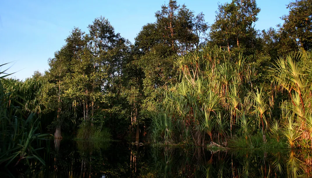
The largest tracts of peat exist in cold, perpetually damp places like Alaska, northern Europe and Siberia. But substantial deposits have also been found in southern Africa, Argentina, Brazil and Southeast Asia. Until the early 20th century, scientists thought that the tropics were too warm—and fallen plant material consumed too quickly by insects and microbes—to harbor peatlands.
Scientists keep finding them, though. Researchers discovered a peat swamp the size of England in the Congo River basin in 2014. And another 2014 study described a 13,500 square mile peatland on one of the Amazon river's tributaries in Peru that holds an estimated 3.4 billion tons of carbon.
Peat bogs, another term for peatlands, are wet, highly acidic and nearly devoid of oxygen. These conditions mean decomposition slows to a crawl. Plant, animal and human remains that fall into peatlands can lay perfectly preserved for hundreds, if not thousands, of years. The carbon contained in these once-living organisms is trapped, slowly buried and sequestered away from the atmosphere over millennia.
But what would happen if these carbon reserves were obliterated? It's an urgent puzzle scientists must now confront even though they're just beginning to answer questions about peat's abundance and distribution.
“They’re key areas for carbon storage,” says Marcel Silvius, a climate-smart land-use specialist with Wetlands International. “If we treat them badly, drain them and dig them up, they become major carbon chimneys.”
Ticking Time Bombs?
In Alaska, as well as across most of the northern latitudes, melting permafrost and shifting rainfall patterns threaten peat bogs. But in the tropics, a different kind of rapidly evolving—and unintended—experiment is already underway.
If all the carbon in the world’s peatlands were to suddenly vaporize, roughly 550 to 650 billion tons of carbon dioxide would pour back into the atmosphere—about twice the volume that’s been added since the start of the Industrial Revolution. Given that peatlands contain between 15 to 30 percent of the world’s carbon stores, their potential for suddenly warming the globe can hardly be understated.
“Because of their constant drawdown of carbon dioxide, [peatlands] are actually cooling the climate,” says René Dommain, a tropical peat expert with the Smithsonian National Museum of Natural History. If peatlands stopped storing carbon dioxide, there's no telling what the long-term environmental impacts would be.
The total, simultaneous destruction of the world’s peatlands is unlikely. But the 14 percent of the world’s peat carbon stock—about 71 billion tons of carbon—stored in the tropical peatlands of Southeast Asia do stand poised on a precipice.
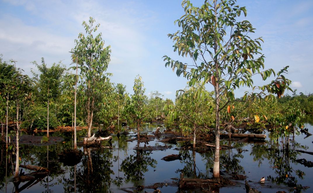
In Malaysia and Indonesia, peat deposits exist beneath thickly wooded lowland forests that have steadily been cleared and drained for the last several decades for agriculture. As trees are removed and peatlands dry out, the deposits start to release carbon in a couple of different ways.
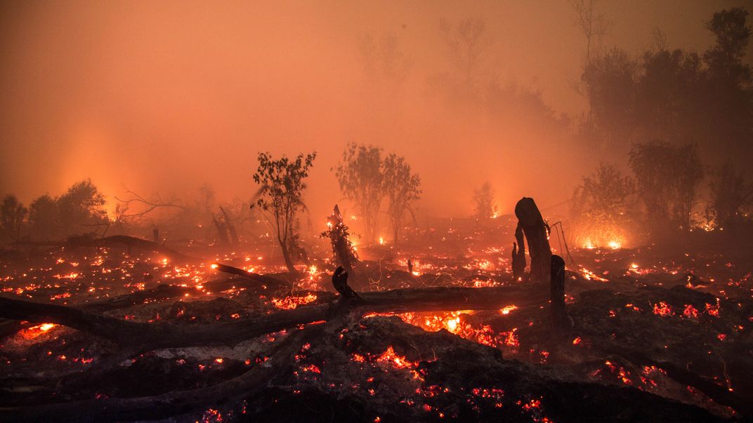
When peat is exposed to air, it begins to decompose, which releases carbon dioxide into the atmosphere. Peat can also wash away along the man-made channels that drain the water, carrying its carbon stores far downstream. Dry peat readily ignites too, often burning uncontrollably or smoldering deep within a deposit's layers like a coal seam fire. These recurring fires pump ash and other particulates into the air, creating public health concerns like respiratory issues and spurring evacuations across the areas where they occur.
As of 2010, 20 percent of the peat swamp forests on the Malaysian peninsula and the islands of Sumatra and Borneo had been cleared for African oil palm plantations or to grow acacia (which is used to produce pulp for paper and other wood products.) Outside of Papua New Guinea, which holds 12 to 14 million acres of pristine peat forest, only 12 million acres of peat swamp forest remain in the Indonesian archipelago.
At the current rate of destruction, the remaining forests outside of Brunei, where the forests are well preserved, will be completely eradicated by 2030, says Dommain.
Under ideal conditions, he says, intact tropical peatlands can store up to a ton of carbon dioxide per acre per year. But because of destructive agricultural practices and new fluctuations in weather patterns, Southeast Asia's peatlands lose about 22 to 31 tons of carbon dioxide per acre each year. That’s more than 20 times what these areas soak up annually.
Over the last two decades, carbon dioxide emissions from drained and degraded peat swamp forests in Malaysia and Indonesia more than doubled, going from 240 million tons in 1990 to 570 million tons in 2010, Dommain says. He plans to publish this analysis in a book later this year.
Pinpointing Hidden Caches
Much of the uncertainty in peat research stems from the fact that scientists don't know the full extent of the planet’s peat reserves. Peatlands are relatively small, widely scattered and hard to find. So for most of the early 20th century, much of what was known about peat reserves around the world came from the written observations of naturalist-explorers who trekked through remote areas describing new landscapes and discovering unknown species.
Since then, new satellite images and analyses, data on standing surface water, re-examination of old maps and more scientific expeditions have filled in a lot of the gaps in our knowledge of where peatlands exist. But there's still a lot left to learn.
Based on a patchwork of data cobbled together from a lot of different sources, scientists think they have good estimates of how much peat is out there, says Columbia’s Nichols. But a lot of our knowledge about the location of peatlands is based on extrapolation, he explains, and only a limited amount of those estimates have been verified by ground-based assessments.
“How much peat there is is a big question we’re still trying to get a handle on,” Nichols says.
Part of the problem is geography. Peat stores tend to be impossibly remote, hostile places. Alaska's Corser Bog, for example, is accessible only by plane or boat. In northern latitudes, humans simply haven't ventured in any numbers into the areas where peat forms. And in the tropics, although there are plenty of people, they’ve historically avoided peat swamps. These areas are nutrient-poor and unfit for agriculture.
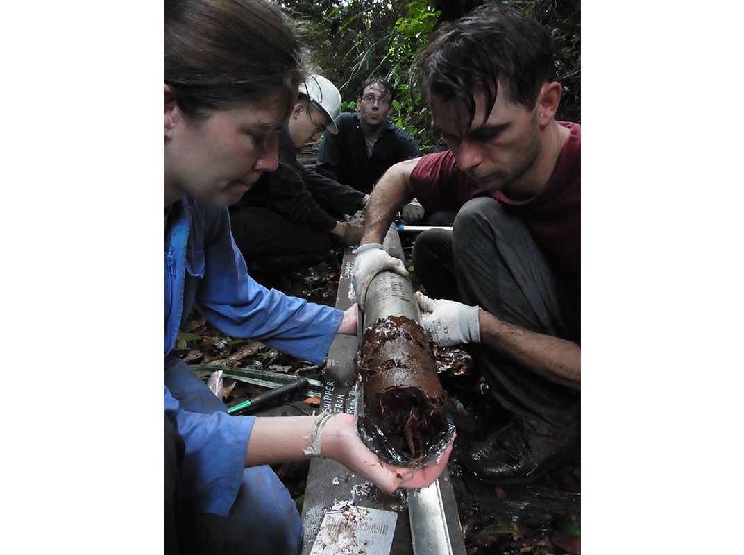
Another issue is that although the surface boundaries of a peatland tend to be well defined, often its depth is not. Satellites and ground-penetrating radar can only see so far down—some bogs in Ireland and Germany are known to be 50 feet deep, far beyond the capacity of roving satellites to measure. So taking cores remains the single best way to determine the depth of a peat bog.
For scientists who study peatlands, that’s not as simple as it seems. They must haul all their equipment for taking samples and measurements from a dry, distant bivouac every day. But once the researchers get on site, they can’t stand still for too long otherwise they start to sink.
“If you take a peat core and dry it, 90 percent of the sample consists of water,” says Dommain. “Walking on a peatland is as close as you’ll get to Jesus, because you’re essentially walking on water.”

Sketching New Views
In the field, the process of determining the physical extent of the peat swamps’ carbon reserves is a slow and often frustrating process. In tropical peat forests—where layers include entire trees, roots and other woody material—even the specialized serrated devices used to extract core samples for study sometimes fail to penetrate very far. On a good day, researchers might be able to extract a single useable sample.
Measuring the rate of gas exchange, or flux, between the peat swamps and the atmosphere is another technique scientists use to study how these areas behave.
Alex Cobb, a research scientist with the Singapore-MIT Alliance for Research and Technology (SMART), uses a variety of techniques to measure the carbon flux from both disturbed and pristine peat swamps on the island of Borneo. From several scaffold towers—one of which rises 213 feet above the forest floor to clear the soaring Shorea albida tree canopy—instruments measure wind speed, temperature and the rate of exchange of carbon dioxide, methane and nitrous oxide between the atmosphere and the ecosystem below. Cobb and his colleagues hope that their monitoring will give them a better understanding of how changes in the water system affect peat forests and how carbon cycling changes accordingly.
“One thing that is challenging is that a lot of carbon is transported [out of the peat bogs] in the groundwater,” Cobb explains. Organic matter in the water turns the liquid the color of strong tea, which is where blackwater rivers come from, he says. "That [water] can account for 10 to 20 percent of the total carbon flux coming out of a degraded peatland.”
A full understanding of the extent of peat carbon stores and how swamps behave remains out of reach. So the ability to predict their behavior, as well as how their contributions to the global carbon cycle might fit into a larger climate model, remains an elusive goal.
Predicting the Future of Peat
As the climate warms, peatlands could go one of two ways if left to their own devices. Expanding plant ranges mean peat accumulation could increase, preserving these areas as carbon sinks. Or, warming causes precipitation fluctuations that cause peatlands to degrade into carbon sources. Not every peatland will respond to warming in the same way, so researchers need computer models to help look at all the possibilities.
Modeling allows scientists to approximate peatland functions in areas where no field measurements have ever been taken. Accurately simulating peatland behavior would allow researchers to estimate carbon and greenhouse gas fluxes without going to the gargantuan effort of visiting each and every peat deposit in the field.
But researchers need data to build accurate models, and the data collected so far isn’t nearly comprehensive enough to use in large-scale simulations. “Data without models are chaos, but models without data are fantasy,” says Steve Frolking, a biogeochemist with the University of New Hampshire who develops computer models for how peat reserves react to natural and human disruptions.
Climate models look at small chunks of area at a time; a high-resolution model’s grid cells are about 62 square miles in size. But this is still too large an area to accurately study peatland behavior.
Another issue is that each peat bog has distinctive water flow characteristics that are highly dependent on localized factors like topography and vegetation. Like soggy little butterflies, each peat swamp is special, and creating a computer model that represents their behavior from a smattering of ground observations leads to huge discrepancies when applied on a global scale.
“Where they are or how they interact each other isn’t part of the detail in these models,” Frolking says. “And for peat, that has a big impact on its hydrology. When you operate at a scale of 100 kilometers and you’re trying to model the water table to within a few centimeters, it becomes really, really hard.”
The third problem is time. Peatlands develop over millennia, while most climate models operate on the order of centuries, says Thomas Kleinen, a global carbon cycle modeler at the Max Planck Institute for Meteorology. This makes inferring the conditions for how a peatland will develop in the future very difficult.
To really be able to integrate peatlands into global carbon and climate models, more comprehensive maps are necessary, as well as more data on the kinds of plants within each peatland, where and how water accumulates, and the depth of the deposits.
Satellite data is useful, as are maps made with data collected by unmanned aerial vehicles, but each has its limitations. Satellites can't penetrate very far beyond thick jungle vegetation or into the ground. And while small countries like Brunei have mapped out all of their peat swamp forests with LiDAR—an aircraft-mounted laser system that can make detailed topographic or vegetation maps, among other things—sprawling cash-strapped nations like Indonesia are unlikely to follow suit.
Turning Back the Tide
As scientists scramble to gather more data and piece together global climate models that include accurate representations of peatland, efforts are underway to curtail the rate of destruction of Southeast Asia's peat.
Indonesia’s Peatland Restoration Agency, assembled in early 2016, aims to restore 4.9 million acres of degraded peatland over the next five years by regulating its usage. The agency will catalog the canals that have already been dug through peatlands, mediate forest usage rights and raise awareness in local residents about the benefits of preserving peat swamps. The Norwegian government and the United States Agency for International Development (USAID) have committed a total of $114 million towards Indonesia's efforts.
Indonesian president Joko Widodo also issued a decree late last year banning the clearing of any new peatlands, even though local restrictions had already been in place. Silvius, of Wetlands International, is skeptical the ban will work, especially since Indonesia has set a goal of doubling its palm oil output by 2020. Though they’re an agricultural area of last resort, peat swamp forests are some of the only remaining land available for farming.
And with widespread poverty in the area, Smithsonian’s Dommain adds that expecting the region to forgo the lucrative profits from palm oil is akin to asking Saudi Arabia to stop pumping oil.
“Human actions are governed by short-term profits and not by what is happening in 10, 50 or even 100 years,” Dommain observes. “It’s hard to see that there will be a massive change in this economic focus.”
However, as the low-slung peatlands that hug the Malaysian and Indonesian coastlines are drained to make way for plantations, they'll eventually sink below sea level. This could permanently flood them, rendering the land unsuitable for any agriculture.
There are ways of preserving these habitats while also utilizing them to grow crops, however. Oranges, rattan, tea tree and sago palm are examples of about 200 crops that can be cultivated within a peat swamp. Some companies are trying to develop a variety of illipe nut, from the swamp-loving Shorea stenoptera, with improved yields. Used as a substitute for cocoa butter in chocolate or in skin and hair creams, illipe may one day aid in schemes to “rewet” drained and degraded peat swamps.
‘The Indonesian government now sees that a drained peatland land-use scheme is asking for trouble,” Silvius says. “They’ll have to voluntarily phase it out, or it will be phased out by nature when everything is lost.”
/https://tf-cmsv2-smithsonianmag-media.s3.amazonaws.com/accounts/headshot/Michelle-Donahue.jpg)