A Decades-Long Quest to Drill Into Earth’s Mantle May Soon Hit Pay Dirt
Geologists have had to contend with bad luck, budget cuts and the race to the moon in their efforts to drill deep into our planet
/https://tf-cmsv2-smithsonianmag-media.s3.amazonaws.com/filer/d2/19/d219d56c-ac5d-40f1-b93c-62a5e659a3f7/broken_drill_bit.jpg)
Early in the spring of 1961, a group of geologists started drilling a hole into the seafloor off the Pacific coast of Baja California. The expedition, the first if its kind, was the initial phase of a project intended to punch through Earth's crust and reach the underlying mantle. Little did they know that their efforts would soon be overshadowed when John F. Kennedy launched the race to the moon in May of that year.
By the end of 1972, after expending billions of dollars and via the collective effort of thousands of scientists and engineers, six Apollo missions landed on Earth's orbital companion and brought home more than 841 pounds of moon rocks and soil.
Meanwhile, the earthbound geologists who dreamt of getting a glimpse of Earth's inner workings were left empty-handed with the remnants of various programs thanks to budget cuts.
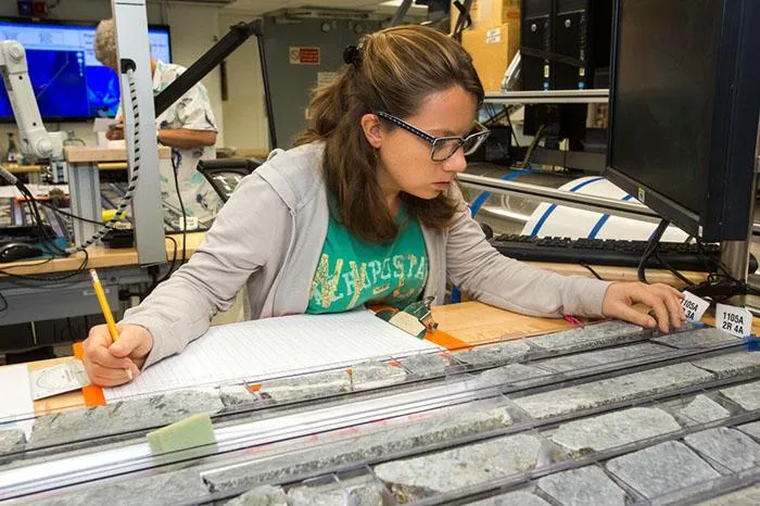
Since the 1960s, researchers have attempted to drill into Earth's mantle but have not yet met with success. Some efforts failed due to technical problems; others have fallen prey to various sorts of bad luck—including, as discovered after the fact, picking inopportune spots to drill. Nevertheless, those efforts have shown that the technology and expertise to drill to the mantle exists. And now the first phase of the most recent attempt to reach this important part of our planet is boring through a thin section of ocean crust in the southwestern Indian Ocean.
Don't worry: When the drillers eventually pierce the mantle, hot molten rock won’t surge up the hole and spill onto the seafloor in a volcanic eruption. Although mantle rocks do flow, they do so at a speed akin to the growth rate of a fingernail, says Holly Given, a geophysicist at Scripps Institution of Oceanography in San Diego.
The mantle is the largest part of this planet we call home, yet scientists know relatively little about it through direct analysis. The thin veneer of crust we live on makes up about one percent of Earth’s volume. The inner and outer core—solid and liquid masses that are largely made of iron, nickel and other dense elements—occupies only 15 percent of the planet's volume. The mantle, which lies between the outer core and the crust, makes up an estimated 68 percent of the planet’s mass and a whopping 85 percent of its volume.
Think of the mantle as a planet-sized lava lamp where material picks up heat at the core-mantle boundary, becomes less dense and rises in buoyant plumes to the lower edge of Earth’s crust, and then flows along that ceiling until it cools and sinks back toward the core. Circulation in the mantle is exceptionally languid: According to one estimate, a round-trip from crust to core and back again might take as long as 2 billion years.
Obtaining a pristine chunk of the mantle is important because it would help planetary scientists better ascertain the raw materials from which Earth accreted when our solar system was young. “It would be ground-truth for what the world is made of,” says Given. Its composition would also provide clues about how Earth initially formed and how it evolved into the multi-layered orb we inhabit today, she says.
Scientists can infer a lot about the mantle, even without a sample. The speeds and paths of earthquake-generated seismic waves passing through the planet provide insight about the density, viscosity and overall characteristics of the mantle, as well as how those properties vary from place to place. So does the rate at which Earth’s crust springs upward after being weighed down by massive ice sheets that have recently (in geological terms) melted.
Measurements of our planet’s magnetic and gravitational fields impart even more information, narrowing down the types of minerals that may be found in the deep, says Walter Munk, a physical oceanographer at Scripps. The scientist, now 98, was part of a small group of researchers that first dreamed up the idea of drilling into the mantle in 1957. But these indirect methods can tell a scientist only so much, he notes. “There’s no substitute for having a chunk of what you want to analyze in your hands.”
Researchers do have samples of the mantle in hand, but they’re not pristine. Some of them are chunks of rock carried to the Earth’s surface by erupting volcanoes. Others were heaved upward by crumpling collisions between tectonic plates. Yet others have risen to the seafloor along slow-spreading mid-ocean ridges, say geologists Henry Dick and Chris MacLeod. Dick, of the Woods Hole Oceanographic Institution in Massachusetts, and MacLeod, of Cardiff University in Wales, are co-leaders of the deep-drilling expedition just now wrapping up in the southwestern Indian Ocean.
All of the current mantle samples have been altered by the processes that brought them to Earth’s surface, exposed to the atmosphere or submerged in seawater for extended periods of time—possibly all of the above. Those mantle samples exposed to air and water have probably lost some of their more easily dissolved original chemical elements.
Hence the great desire to obtain an unsullied chunk of mantle, says Dick. Once available, scientists could analyze a sample’s overall chemical composition as well as its mineralogy, assess the density of the rock and determine how easily it conducts heat and seismic waves. The results could be compared to the values inferred from indirect measurements, validating or disputing those techniques.
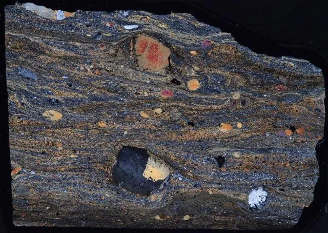
Drilling all the way to the mantle would also give geologists a look at what they call the Mohorovičić discontinuity, or Moho, for short. Above this mysterious zone, named for the Croatian seismologist who discovered it in 1909, seismic waves travel at around 4.3 miles per second, a rate consistent with those waves traveling through basalt, or cooled lava. Below the Moho, the waves rip along at around 5 miles per second, similar to the rate they travel through a silica-poor type of igneous rock called peridotite. The Moho typically lies between 3 to 6 miles below the ocean floor and anywhere between 12 to 56 miles beneath the continents.
This zone has long been considered the crust-mantle boundary, where material gradually cools and sticks to the overlying crust. But some lab studies suggest it’s possible that the Moho represents the zone where water seeping down from the overlying crust reacts with mantle peridotites to create a type of mineral called serpentine. This possibility is exciting, Dick and MacLeod suggest. The geochemical reactions that generate serpentine also produce hydrogen, which can then react with seawater to produce methane, a source of energy for some types of bacteria. Or, the researchers note, the Moho could be something else entirely unknown to science.
The key to unlocking the secrets of the mantle is to find the right location at which to drill. Mantle material rises to the ocean floor at mid-ocean ridges, where tectonic plates slowly push apart. But those samples just won't do. Working through a few miles of crust below the ocean floor changes the material considerably, rendering the mantle sample unrepresentative of what's deep within Earth. And drilling deeper at one of these ridges is also problematic, says Dick. “At an ocean ridge or its immediate flanks, the crust is too hot to drill more than about one or two kilometers.”
So he and his colleagues are drilling at a spot in the southwestern Indian Ocean called Atlantis Bank, which lies about 808 miles southeast of Madagascar. Many factors make this locale an excellent place for the expedition to drill, says Dick.
For one, this Denver-sized patch of seafloor sits atop ocean crust that’s about 11 million years old, making it cool enough to drill into. For another, the top of the bank is a 9.7-square-mile plateau that's within 2,300 feet of the ocean surface. That makes tapping the ocean bottom there, as opposed to the 3.7-mile deep seafloor nearby, a no-brainer. Strong ocean currents in the area have kept sediments from piling up on the seafloor, keeping the crust there largely exposed. It's also relatively thin—a previous seismic survey of the area found that the crust there is only 1.6 miles thick.
Moreover, the ocean crust beneath Atlantis Bank formed at a section of mid-ocean ridge where the upper layers of nascent crust spread in one direction from the rift, while the lower layers moved in the other. Scientists aren't yet sure how or why this happened. But, due to this so-called asymmetrical spreading, which probably occurs at a substantial fraction of the world’s mid-ocean ridges, Atlantis Bank isn’t cloaked with brittle layers of upper crust that can shatter and fall into a hole as it’s being drilled, says Dick. Such debris can damage the drill bit or cause it to seize up, as well as make it difficult to flush smaller bits of rock and mud from the hole.
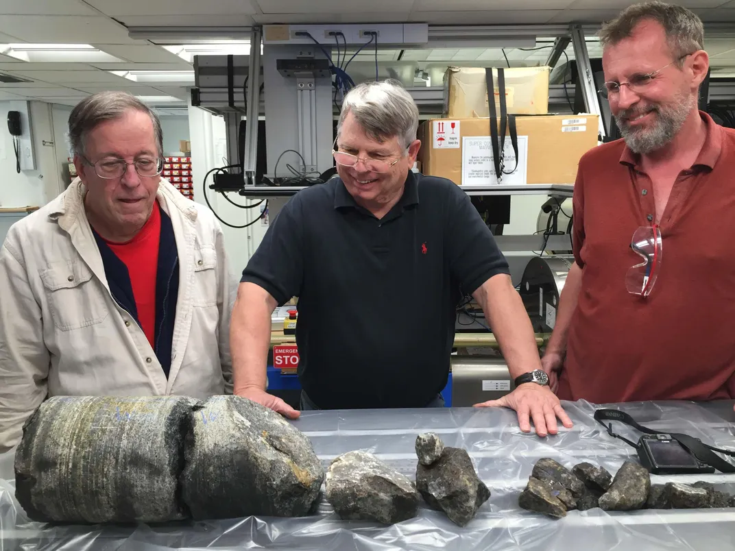
Despite the benefits of drilling at Atlantis Bank, the expedition has suffered setbacks common to many ocean drilling projects. Issues with loading the ship delayed the team's departure from Colombo, Sri Lanka by a day. Once on site the team broke a drill bit, but before they could fish the pieces out of their hole, they had to pack up and take a sick crewmember north toward Mauritius to meet a shore-based helicopter for a medical evacuation. The ship, named the JOIDES Resolution, returned after nearly a week away and then had to spend a couple of days using a strong magnet to try and recover the pieces of their broken drill bit.
They never found those missing pieces. But during a last-ditch effort using a strong vacuum to try and slurp them up, the expedition brought back what may be the largest-diameter chunk of ocean crust ever recovered. The cylinder of dark, coarse-grained rock, called gabbro, is 7 inches across—three times the normal size—and 20 inches long.
The team’s target depth for this expedition was 4,265 feet into the crust, barely halfway to the mantle. Unfortunately, as of January 22, drilling had only reached a depth of 2,330 feet beneath the seafloor.
By the time this article is published, drilling operations will be wrapping up at Atlantis Bank—for this leg of the project. A second, already-approved leg of the mission would hopefully complete the task and tap into the mantle. But that could be anywhere from two to five years from now. Competition for ship time from other teams who wish to drill elsewhere in the world is fierce, says Dick.
The science team won't come away from the first phase of this project empty-handed though, says MacLeod. Recovering samples from throughout Earth's crust is also important. “We have no idea what the bulk composition of the ocean crust is at any place on the globe,” says Dick. Lower crust rocks previously recovered from other deep-drilling sites have been nothing like what researchers expected, he says.
The Atlantis Bank project would provide a look at the chemical composition of the lower crust. And a full profile through the entire layer would help scientists understand how magmas are chemically and physically transformed there—including how mantle rocks crystallize and become attached to the lower surface of the crust.
Once researchers eventually get their mantle sample, other teams can piggyback on the project with experiments of their own, says MacLeod. “Future expeditions may be dropping instruments down the hole for years to come.” For example, seismologists can send sensors down into the miles-deep hole and then directly measure the velocities of seismic waves pulsing through Earth’s crust, rather than infer them via laboratory tests on small samples of rock. Researchers can also lower a string of temperature sensors into the hole to measure heat flow from our planet’s interior.
Undoubtedly, the samples of ocean crust and mantle eventually retrieved from Atlantis Bank—as well as data gathered from the hole left behind—will keep geologists and geophysicists busy for decades to come. But patience is a virtue, and biding their time is what Dick, MacLeod and their geophysical brethren have been doing for decades.
Editor's Note: This article has been updated to correct the attribution of a seismic survey of Atlantis Bank.