Chronicling the Ice
Long before global warming became a cause célà¨bre, Lonnie Thompson was extracting climate secrets from ancient glaciers
/https://tf-cmsv2-smithsonianmag-media.s3.amazonaws.com/filer/ice-mountain.jpg)
Even from the top of a 16,000-foot pass, Tibet's Naimona'nyi looks formidable, and the closer we get to it, the larger it looms, until, finally, its ice-glazed face disappears behind the steep, rock-strewn ridge we have yet to climb. At 25,242 feet, Naimona'nyi is the highest mountain in southwestern Tibet and the 34th highest in the world.
Below us runs a glacier-fed river turned milky by pulverized rock. The fall equinox has passed, and shrubs and grasses are turning crimson and gold. "Look at all the colors," Lonnie Thompson exclaims, delighted that winter is finally on the way. The onset of bitter cold might seem an odd thing to welcome, but, he says cheerfully, "for the ice it's good."
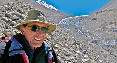
Thompson, one of the world's foremost glaciologists, is the leading authority on high-altitude glaciers of the tropics and near tropics, and he is as renowned in scientific circles for his physical courage as for the pathbreaking publications that stream from his lab. "An absolute hero," says Gavin Schmidt, a climate modeler at NASA Goddard.
This is Thompson's 51st major ice-coring expedition. All told, he has spent more than three and a half years at elevations above 18,000 feet. He has endured frostbite and altitude sickness. He rode a Mongolian pony for three days through driving snow and rain on a 1986 expedition to China's Qilian Shan mountains. During a 1993 expedition to Huascarán, the highest mountain in Peru, he crawled across a yawning crevasse on a rickety wooden ladder; camped at 19,800 feet, he was trapped inside a tent as hurricane-force winds carried it toward a precipice. He averted a fall only by stabbing an ice ax through the tent floor.
Ice is like a time capsule that preserves the abrupt shifts in climate that have changed the course of human history. From the Quelccaya ice cap—a cap is larger than a glacier—in southern Peru, Thompson and his colleagues pieced together the droughts and floods that unhinged pre-Incan civilizations. In layers of ice cored from the Dasuopu glacier high in the Himalayas, they identified the dusty fingerprints of monsoon failures that have punished the Indian subcontinent with recurrent famine since A.D. 1440. Now Thompson, who is based at Ohio State University, is using high-altitude ice samples to come to grips with global warming.
"What really stands out," he says, "is how unusual the last 50 years have been compared to at least the last 2,000 and perhaps the last 5,000 years." Rising temperatures are rapidly reducing the ice that permanently caps high mountains around the world. Well before the end of this century, much, and in some areas most of it, will be gone. The loss is a harbinger of even larger, potentially catastrophic, consequences.
Thompson, I'm relieved to learn, does not intend to climb to the top of Naimona'nyi, which was not successfully summited until 1985. But the plan that he has devised with Yao Tandong, director of the Chinese Academy of Sciences' Institute for Tibetan Plateau Research and Thompson's longtime collaborator, is in some ways even more daunting. From our present elevation, about 16,000 feet, they aim to hike another 4,000 feet to the head of a massive ice field in the shadow of Naimona'nyi's highest peak. They will remain there for as long as it takes to drill down to bedrock and extract two or three continuous cores of ice, each hundreds of feet long.
We wait days for Yao's team to assemble a sufficient number of yaks. We breakfast, Chinese-style, on steamed bread and pickled vegetables and sort through gear to pass the time. Thompson is clearly eager to get under way. Finally, a jangle of bells announces the arrival of a small herd of yaks, bringing the number of pack animals to about 18. The yak herders load our stuff onto the backs of these curious bovines, excellent climbers with horns like buffaloes and tails like horses.
Then Thompson and his five-member team are off, with Vladimir Mikhalenko, an ice driller from the Russian Academy of Sciences' Institute of Geography, leading the way. Following close behind are chief driller Victor Zagorodnov, glaciologist Mary Davis, graduate student Natalie Kehrwald and geochemist Ping-Nan Lin, all from Ohio State University (OSU). Thompson waves cheerily. "It'll be a walk in the park," he promises.
Half an hour later, I head out with my husband, Thomas Nash, a physicist and photographer; we trail a second group of hikers led by Yao, which will meet up with Thompson's group later in the day. The sharp incline is unrelenting, and I find that I am soon reduced to a rhythm of ten steps followed by a pause in which I suck in an equal number of breaths. In this tortured fashion, I eventually reach 18,400 feet, at which point the scenery explodes.
Far below I can see Lake Manasarovar, described by Swedish explorer Sven Hedin a century ago as "an enormous turquoise embedded between two of the finest and most famous mountain giants of the world," Kailash and Naimona'nyi. This stunning tableau, about 10 miles from Nepal and 20 miles from India, is among the world's most sacred landscapes. According to Hindu and Buddhist belief, this is the center of the universe, and four great rivers are said to flow through subterranean passages. This is figuratively true: four of Asia's most important waterways—the Indus, the Sutlej, the Brahmaputra and the Ganges—are fed by the snow and ice fields of this mountainous region.
As we set up our tent for the night, I feel pressed in upon by walls of gray, unstable rubble, the legacy of some long-ago era when the ice here was advancing rather than retreating. We awake to see the sun starting its slow pan across our deep, dark valley. It will be at least another hour before the glacier-fed stream below throws off its frozen quilting. Pulling on layers of fleece, Thomas and I join the others for breakfast. Between sips of steaming tea, I study Thompson.
Now 58, he seems little changed from the man I first met a decade ago, though his brown hair has grayed and his asthma, which was diagnosed some 15 years ago, sounds a little worse. Of medium height and build, he's not physically imposing. But he possesses nearly superhuman determination and drive. The second child of three, Thompson spent his formative years on a small farm in Gassaway, West Virginia. Neither of his parents went beyond the eighth grade, though his mother later earned her high-school equivalency. The family struggled financially, even before Thompson's father, an electrician, died when Lonnie was in high school. At one point the young man held four jobs to bring in needed income. In 1966 he won a scholarship to West Virginia's Marshall University, where he majored in geology. There he met Ellen Mosely, a petite physics major who went on to get a PhD in geography; she is Thompson's scientific partner, and they've been married for nearly four decades.
Though it has taken many years, honors and prizes are flowing Thompson's way. This summer, he will be awarded the National Medal of Science by President Bush. But Thompson's lifestyle remains simple. He and Mosely-Thompson still live in the unpretentious white-frame house they bought a quarter century ago in Columbus, Ohio; their daughter, Regina, an FBI agent, and her husband live nearby. For exercise, the Thompsons walk their small dogs, Russ and Kino, in a little park down the street.
Initially, Thompson says, he wanted to become a coal geologist, combining his interest in earth sciences with a desire to make a good living. Glaciology did not attract him at all. "I can remember studying glaciers [at Marshall] and thinking to myself, what a waste! Glaciers take up only a very small percentage of the surface of the earth; they're in really remote areas where people could not care less about what happens, so why in the world would anyone take the time to study them?" After a brief stint in the National Guard, Thompson enrolled in 1972 as a graduate student at OSU and, to defray expenses, hired on as a research assistant at the university's Institute of Polar Studies. He soon found himself staring at the first deep ice core ever retrieved from Antarctica. It was a revelation.
For those who can decipher its arcane script, ice has fascinating stories to tell. Fluctuations in various isotopes, or atomic forms, of oxygen document swings between warm and cold epochs; fluctuations in nitrate levels mark how plants respond to the expansion and contraction of ice. Ice contains bubbles of air from ancient atmospheres and layers of ash from long-ago volcanic eruptions. It contains layers of windblown dust that yield information about broad shifts of precipitation, rising during dry epochs and falling during wet. And ice records shifts of precipitation in the form of thicker and thinner annual layers.
For a long time, glaciologists gave little thought to the high-elevation ice of the lower latitudes. (At about 30 degrees of latitude, Naimona'nyi falls within the near tropics.) The scientific action, it was all but universally assumed, lay in the dramatic expansions and contractions of the great ice sheets in Antarctica and Greenland. Besides, most scientists assumed that ice anywhere close to the Equator would have melted and refrozen many times, erasing any history written in its layers.
Two years before getting his PhD, Thompson accompanied Ohio State geologist John Mercer on an exploratory expedition to Peru's Quelccaya ice cap. Mercer had the idea that it might tell him whether major advances of ice in the Northern and Southern hemispheres occurred at the same time. It was a problem that also interested Thompson, who was then comparing dust layers in ice from Antarctica and Greenland.
Which is why, in the summer of 1974, Thompson had his first encounter with the dazzling expanse of white that would change his life forever. Some 18,700 feet high, the huge Quelccaya ice cap extended over 22 square miles. But what enthralled him was its dramatic western face. It looked remarkably like a 180-foot-high wedding cake, with layers of pellucid ice alternating with layers darkened by dust. Had Quelccaya ever melted, Thompson realized, those sharply delineated layers would have collapsed into homogenized slush.
It was the start of an epic struggle to study the ice cap, one that many predicted Thompson would lose. "Quelccaya is too high for humans, and the technology [to drill it] does not exist," Denmark's Willi Dansgaard, one of the titans of glaciology, famously observed. Indeed, Thompson's first big expedition to Quelccaya, in 1979, ended ignominiously when the Peruvian pilot commissioned to airlift the heavy drilling equipment grew nervous about high winds and backed off. Before Thompson returned to the ice cap, he applied to Ohio State's MBA program. If he came back empty-handed again, he had decided, he would quit glaciology and apply his talents elsewhere. "And probably," he says today, "I would have made a lot more money."
But Thompson and colleagues returned from Quelccaya triumphant, in possession of a 1,500-year-long climate record. Clearly preserved in the ice were dramatic swings from wet to dry that coincided with variations in sea-surface temperatures characteristic of the El Niño climate cycle. Preserved, too, were longer-term swings, from rainy spells to droughts lasting decades and even centuries, and in which archaeologists found eerie parallels to the rise and fall of the great pre-Incan civilization of Tiwanaku that flourished along the shores of Lake Titicaca more than a thousand years ago. Thompson then knew that his ice cores could capture climate—and human—history.
With an average elevation of around 15,000 feet, the Tibetan Plateau, which Naimona'nyi helps define, is the world's highest and largest plateau, encompassing an area one-third the size of the continental United States. Colossal mountains, including 29,035-foot Chomolungma, which is what the Tibetans call Mount Everest, stand guard over the plateau. This area holds the largest amount of ice in the world outside the polar regions, one reason it is often referred to as the Third Pole.
In geologic terms, the Tibetan Plateau is fairly recent. The uplift that created it began about 55 million years ago, when the Indian subcontinent crashed into Eurasia. The battle between these two giant slabs of earth's crust continues to this day, pushing the Himalayas skyward by nearly a half inch per year. As the plateau was slowly uplifted, it reached into progressively thinner layers of the atmosphere, each one less capable of screening out ultraviolet radiation in summer and trapping infrared heat in winter.
At some point, probably between 15 million and 22 million years ago, the temperature swing from summer to winter became so extreme that it powered the Asian monsoon, a giant oscillating breeze that drives the yearly rain cycle across a vast swath of Asia, the most populous region on earth. In summer, the Tibetan Plateau heats up, and like a huge hot-air balloon, air across the plateau rises, creating a zone of low pressure that sucks in moist air from the Bay of Bengal and the South China and Arabian seas, bringing rain to much of Asia. In winter, cold air descends from the Tibetan Plateau and pushes dry continental air seaward.
The Asian monsoon created the modern-day river basins whose fertile flood plains sustain about half the world's population. Many scientists believe the monsoon also helped cool the planet. Ever so slowly, the rains removed carbon dioxide, the heat-trapping gas most responsible for global warming, from the atmosphere. When the gas is dissolved in rainwater, it turns into an acid, which then reacts with rock to form more stable carbon compounds. In this fashion, says Boston University paleoclimatologist Maureen Raymo, the Asian monsoon set the stage for the succession of ice ages that started about three million years ago.
Now it is becoming clear that such natural mechanisms for sequestering atmospheric carbon dioxide are being overwhelmed by the burning of fossil fuels—coal, oil and natural gas. There is more carbon dioxide in the atmosphere today than at any time during at least the past 650,000 years, based on analyses of the chemical composition of air bubbles entrapped in Antarctic ice over that time. By the end of this century, carbon dioxide levels could easily double, and many scientists expect global warming to disrupt regional weather patterns—including the Asian monsoon.
There is no question that big changes are already afoot in the Tibetan Plateau. In 2004, Chinese glaciologists published a survey of their country's 46,298 ice fields, the majority of which lie in Tibet. Compared with the 1960s, the area covered by glaciers shrank by more than 5 percent, and their volume by more than 7 percent, or more than 90 cubic miles. That much ice holds enough water to nearly fill Lake Erie. Moreover, the rate of ice loss is speeding up. At present, Yao tells me, the glaciers near Naimona'nyi are drawing back by eight million square feet per year, five times their rate of retraction in the 1970s.
The loss of high-mountain ice in the Himalayas could have terrible consequences for people living downstream. Glaciers function as natural water towers. It's the ice melt in spring and fall that sends water coursing down streams and rivers before the summer monsoon arrives and after it leaves. At present, too much ice is melting too fast, raising the risk of catastrophic flooding; the long-term concern is that soon there will be too little ice during those times when the monsoon fails, leading to drought and famine.
Worldwide, a massive loss of ice, a long-predicted consequence of global warming, is now in progress, from Alaska to Patagonia, from the Rockies to the Alps. Even more disturbing, the great ice sheets that cover West Antarctica and Greenland are showing signs of instability. The mile-deep Greenland ice sheet, Thompson notes, contains enough water to raise sea level by something like 20 feet, and while neither he nor anyone else expects all that ice to disappear suddenly, it's clear that its accelerating loss will contribute to rising oceans.
Speaking out in the early 1990s, Thompson was one of the first scientists to call the public's attention to glaciers and ice fields as barometers of climate change. He has continued to do so in the years since, reinforcing his message with hard data and before-and-after photographs of disappearing ice fields. Today he has a lot of company. As temperatures push ever higher over the next century, the latest United Nations report warns, the loss of ice can be expected to continue, reconfiguring coastlines and ecosystems on a global scale.
Thompson is starting the arduous climb to the drilling camp, located high on an ice-filled corridor between two glaciers. He moves steadily but slowly, drawing his breath in ragged gasps. Every now and then he pauses to bend at the waist, as if taking a bow. It's a trick, he says, for easing the burden that high altitude places on the heart.
He stops at the top of a tower of rocks deposited by a past advance of ice. Directly below is the glacier he plans to climb. "It'll be a walk in the park," Thompson says, panting. Shortly, he moves off, clambering across the ice-mauled debris that limns the glacier's course. "That's what you said last time," I yell after him.
My husband and I decide to head back to Lhasa.
Thompson's team would spend two weeks on the glacier and pull out three cores, one more than 500 feet long (contained in about 140 tubes), representing thousands of years of the glacier's and the atmosphere's history. Then, because their permits had expired, they returned to Lhasa, entrusting their Chinese colleagues with getting the ice off the glacier. It was not an easy task. The first truck hired to haul the cores the 900 miles back to Lhasa never showed up. Porters and yak herders threatened to quit. A two-day snowstorm struck. A second truck choked on the thin air; to keep it running, its drivers had to inject oxygen into the engine from a bottle fetched from Lhasa.
About two months after leaving Tibet, I step into the cavernous freezer at OSU's Byrd Polar Research Center. The temperature stands at minus 30 degrees Fahrenheit. Here, stashed on steel shelves, are thousands of shiny aluminum tubes that hold Thompson's collection of ice cores. Organized by expedition, the tubes measure a meter in length; their caps bear an identifying set of letters and numbers.
My companion, graduate student Natalie Kehrwald, is making a first pass through the Naimona'nyi cores, and even though she's dressed in a wool hat and down jacket, she doesn't linger long in the freezer. Pulling out the tube she wants, she dashes from the freezer to a small anteroom that, mercifully, is some 50 degrees warmer. There she pulls out a cylinder of ice and places it on a light table. This section of the core contains subtly alternating bands of clear and cloudy ice. The transparent bands mark intervals of high precipitation, while the more opaque bands signify drier, dustier times. The pattern is strangely beautiful.
Kehrwald examines other lengths of ice. One, from a depth of about 365 feet, is filled with fine air bubbles, which often form under extremely cold conditions. Another, from an even greater depth, contains ice so clear it looks like glass. But it's the ice from closer to the surface that causes the most excitement, for some of it contains intriguing dark flecks that may be fragments of insects or plants—remains that can provide solid rungs in the ladder of time.
Thompson's Andean ice, for example, contains ash from known volcanic eruptions, like Huaynaputina's in southern Peru in a.d. 1600. It also incorporates organic detritus that can be radioactively dated. In 1998, Thompson found the remnants of a 6,000-year-old insect in the ice he wrested from a dormant Bolivian volcano. In 2004 and 2005, he recovered 5,200-year-old marshland plants from the Quelccaya ice cap's shrinking edges. Insects and plants near the top of an ice cap or glacier are not so important, since the upper layers bear stripes that reveal the years like tree rings. But establishing dates becomes critical deep in the core, where the weight of overlying ice squeezes annual layers of snow so close together they seem to merge. Just a smattering of independently derived dates from organic material would help nail the Tibetan timelines to the wall.
As Thompson looks at his cores across a long fetch of space and time, he sees what appears to be a wavelike sweep of ice growth proceeding south to north across the Equator. This pattern, Thompson says, bears a striking correspondence to a 21,500-year astronomical cycle. Known as the precessional cycle, it derives from the fact that the earth, like a child's top, wobbles as it spins, altering the time of year in which the Northern and Southern hemispheres come closest to the sun. That, in turn, affects precipitation patterns, including the strength of monsoons.
The precessional pattern is still at work, says Thompson, but its influence is becoming harder to detect. "To me this is what makes our world today seem so different from the past," he muses. "If nature alone were in charge, then glaciers should be growing in the lower latitudes of one hemisphere and retreating in the lower latitudes of another. But that's not what's happening." As he sees it, the fact that glaciers and ice fields are dwindling virtually everywhere constitutes the clearest sign yet that rising concentrations of greenhouse gases are profoundly damaging the natural system.
A couple of months before heading off for Naimona'nyi, Thompson says, he revisited Peru's Quelccaya, where the ice is now receding at an alarming rate. Qori Kalis, the outlet glacier he's regularly measured for the past 28 years, has thinned so much that he expects it will have vanished by the time he returns this year. As for Mount Kilimanjaro, the highest peak in Africa, he says, "its ice fields are now just spikes. And once you lose the ice, you lose the history, you lose the record." Fortunately, Thompson got to that iconic mountain just in time; seven years ago he mounted an expedition that pulled out an 11,700-year record of the climate swings in East Africa, including a drought 4,000 years ago that coincided with the collapse of Egypt's fabled Old Kingdom. He keeps a list in his head of 13 more high-elevation ice fields that he'd like to drill before it's too late, including the rapidly shrinking Carstensz glacier on 16,023-foot Mount Jaya, New Guinea's highest peak. He admits he probably can't get to them all.
Perhaps not surprisingly for a native West Virginian who once considered a career in coal geology, Thompson often draws an analogy between glaciers and the proverbial canary in the coal mine. Like the bird, glaciers are warning us of the buildup of dangerous gases. But there is one important difference. "In the past, when the canaries stopped singing and died, the miners knew to get out of the mine. Our problem is, we live in the mine."
J. Madeleine Nash is the author of El Niño: Unlocking the Secrets of the Master Weather-Maker. Thomas Nash is a physicist and photographer. They live in San Francisco.