75 Years of the Blue Ridge Parkway
Winding its way through Appalachia, the scenic road is the result of workers and politicians who blazed the trail in the 1930s
/https://tf-cmsv2-smithsonianmag-media.s3.amazonaws.com/accounts/headshot/jim-morrison-240.jpg)
/https://tf-cmsv2-smithsonianmag-media.s3.amazonaws.com/filer/Blue-Ridge-Parkway-road-autumn-631.jpg)
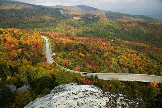
The sign marking the commencement of construction for the Blue Ridge Parkway is an unassuming gray roadside plaque, a few hundred yards from the North Carolina-Virginia border near Cumberland Knob. The low profile seems appropriate here. The parkway’s pleasures are subtle, harking back to a time when traveling was about the journey, not just the destination.
Around every bend, it seems, awaits another enticing vista, whether it’s a hawk’s-eye view of a river valley, a peaceful pasture crowded with cows, or a tree-covered peak. About 16 million people visited last year, making it the National Park Service’s most popular attraction (by comparison, Yosemite and Yellowstone national parks each attracted over 3 million people in 2009). “The Scenic,” as locals called it in the early days, celebrates its 75th anniversary this year.
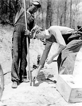
On September 11, 1935, about 100 workers started clearing and grading land on Pack Murphy’s farm, beginning the parkway’s initial 12.5-mile-stretch from the Virginia- North Carolina border south to Cumberland Knob. It was the first of 45 segments of the parkway, which traces 469 undulating miles from the northern entrance at Rockfish Gap, Virginia, where it connects to Skyline Drive and Shenandoah National Park, to Cherokee, North Carolina, and the eastern entrance to Great Smoky Mountains National Park.
The country’s ultimate crooked road tops mountain crests, dips into river valleys and meanders through farmlands and national forests. It crosses four major rivers, more than 100 gaps and six mountain ranges, dropping to 649 feet above sea level near the James River in southwest Virginia and climbing to 6,053 feet near Mount Pisgah, in North Carolina so there’s a wide range of ecosystems.
Planners envisioned the parkway as a new kind of road. “It is the first use of the parkway idea, purely and wholeheartedly for the purposes of tourist recreation distinguished from the purposes of regional travel,” wrote Stanley W. Abbott, the landscape architect whose vision guided the parkway’s design and central themes.
“Like the movie cameraman who shoots his subject from many angles to heighten the drama of his film, so the shifting position of the roadway unfolds a more interesting picture to the traveler,” Abbott wrote in 1939 after much of the route had been set. “The sweeping view over the low country often holds the center of the stage, but seems to exit gracefully enough when the Parkway leaves the ridge for the more gentle slopes and the deeper forests.”
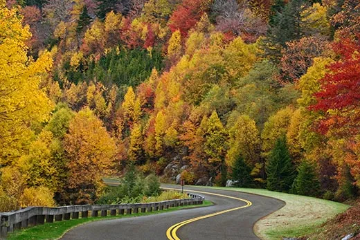
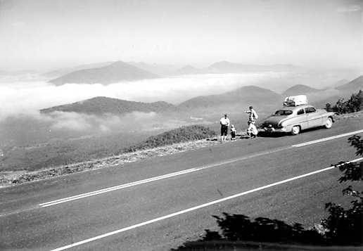
Along the two-lane road, there is not a single billboard, stop sign or traffic light. Utilities are buried. Signs are few. Only the mile markers are a constant. Entrances to the parkway appear regularly, but they are unobtrusive with no hint of civilization in sight. The parkway succeeds in fulfilling Abbott’s desire to eliminate the “parasitic and unsightly border development of the hot-dog stand, the gasoline shack, and the billboard” so that the natural scenery prevails. Cruising along at the speed limit of 45 miles per hour is like taking a step back in time.
Abbott, who earned his degree from Cornell University and had worked on the Westchester and Bronx River parkways, referred to the parkway as a “managed museum of the American countryside” and he sought to purchase right of ways that would preserve the vistas. He wanted to create a series of “parks within parks,” places to hike, camp, fish and picnic. So at intervals the ribbon of highway, endless skyway, widens to include recreational areas, what Abbott called “beads on a string, the rare gems in the necklace.”
Over the years, the park service has added or restored cultural attractions like the Blue Ridge Music Center at the parkway’s midpoint, which features concerts in an outdoor amphitheater; or Mabry Mill, a century-old gristmill; and Johnson Farm, a restored 1930s living history attraction. The many small towns along the route, like Floyd, Virginia, and Asheville, North Carolina, have seized upon their arts and crafts and musical heritage to become cultural destinations.
“What continues to catch the imagination of the American public and why they come to the parkway is the diversity,” says Dan Brown, who retired from the park service in 2005 after five years as the parkway’s superintendent. “The parkway traverses some of the most outstanding natural areas to be found in the eastern United States and it also travels through some very special cultural lands. The American public has always been intrigued by the southern Appalachian culture. The music and the crafts of the region are second to none.”
A scenic drive along the spine of the Blue Ridge had been proposed as early as 1906. In 1933, President Franklin Roosevelt visited Shenandoah National Park and was impressed by Skyline Drive, then under construction. Senator Harry Flood Byrd of Virginia suggested a mountain road extending to Great Smoky Mountains National Park, and Roosevelt expressed interest and Byrd secured backing from elected officials in North Carolina and Virginia. On November 24, 1933, Secretary of the Interior Harold Ickes announced approval of the parkway and $4 million was allocated to begin work.
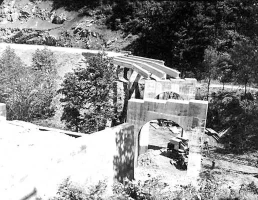
Abbott and his contemporaries were admirers of Frederick Law Olmsted, the designer of Central Park. Just like Central Park, the parkway would appear to be natural, but that appearance would be the result of human imposition. Politics would play a part as well, as individual landowners, towns and states fought over the route (North Carolina won the biggest battle over Tennessee to host the southern portion of the parkway).The first 50-mile section near Roanoke opened in April 1939. About two-thirds of the road was completed by 1942, when the war halted construction. All but the section with the Linn Cove Viaduct, in North Carolina, was completed by 1967.
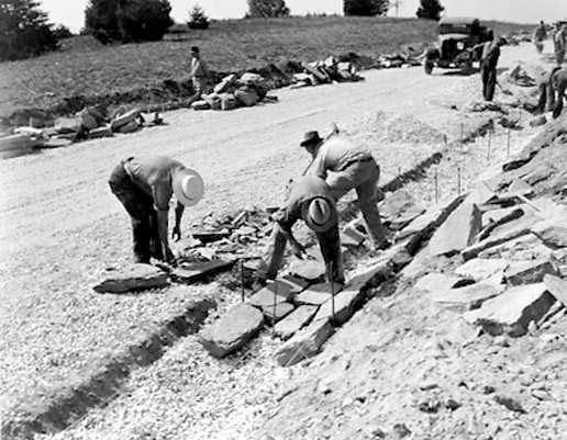
Little of the land was pristine. It had been timbered, farmed and commercialized. So thousands of trees and tons of dirt were moved. Much of the early labor was done by hand. The Public Works Administration’s first contract paid men 30 cents an hour for a six-day week.
“I can’t imagine a more creative job than locating that Blue Ridge Parkway, because you worked with a ten-league canvas and a brush of a comet’s tail. Moss and lichens collected on the shake roof of a Mabry Mill measured against the huge panoramas that look out forever,” Abbott said in an interview years later.
Anne Whisnant, a longtime parkway traveler and author of Super-Scenic Motorway: A Blue Ridge Parkway History, notes that the designers’ desires often met with political reality. “The fact remains they were pushing this through a populated landscape,” she notes, taking land by using eminent domain. The designers wanted a 800-to-1,000-foot right of way, but in Virginia, in particular, they couldn’t get it because the legal mechanisms were not robust enough. To Whisnant, that means the parkway through Virginia is a less satisfying experience, more interrupted by access roads and with more views encroached by development.
Abbott pioneered “scenic easements” that allowed the park service to acquire all development rights without having to pay for the land, in essence buying the view at a considerable savings.
As the park ages and homes along its narrow corridor become more popular, it faces increasing pressure from encroachment of those view sheds. “Most of the parkway landscape, the things people love about it, is borrowed, “ Whisnant says. “There is a big job working closely with those who own the landscape in trying to create some kind of joint sense of benefit so we all work to protect it.”
Looking back, Whisnant says the parkway’s history is comforting when she thinks of the road’s future. “A lot of the problems facing the parkway have been endemic and central since its first day,” she says. “What each generation has to do is take up the challenges, think about them and make decisions. Do we value this or not? If we do, how do we act so it’s preserved? It’s the same thing we’ve done for 75 years.”
/https://tf-cmsv2-smithsonianmag-media.s3.amazonaws.com/accounts/headshot/jim-morrison-240.jpg)